TopoQuest Logo
Do you find TopoQuest useful?
Help keep TopoQuest running and adding new maps/features by donating!
Bitcoin:  19c7KJd3qBynnjoSw5npx9KScwjBe4ifkT
Litecoin:  LXs6TkuXGGXo1vDsWCkWVdjQX94eUKd6ui
Home View Maps Find Maps Find Places Resources & Links


Charlton, Mississippi Topographic Map

USGS Map Title: Charlton, MS
USGS Map MRC: 32090E2
DRG (GeoTIFF) Download: o32090e2.tif


Neighboring USGS Topographic Map Quads:


  Bentonia, MS  
32090F3
 

  Berryville, MS  
32090F2
 

  Way, MS  
32090F1
 

  Flora, MS  
32090E3
 

  Charlton, MS  
32090E2
 

  Canton, MS  
32090E1
 

  Pocahontas, MS  
32090D3
 

  Ridgeland, MS  
32090D2
 

  Madison, MS  
32090D1


Map MRC Location:

N33°
W91°
N33°
W90°
H8 H7 H6 H5 H4 H3 H2 H1
G8 G7 G6 G5 G4 G3 G2 G1
F8 F7 F6 F5 F4 F3 F2 F1
E8 E7 E6 E5 E4 E3 E2 E1
D8 D7 D6 D5 D4 D3 D2 D1
C8 C7 C6 C5 C4 C3 C2 C1
B8 B7 B6 B5 B4 B3 B2 B1
A8 A7 A6 A5 A4 A3 A2 A1
N32°
W91°
N32°
W90°

Charlton, MS USGS 1:24K Topographic Map Preview:
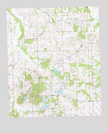
Charlton, MS USGS Topographic Map
Click on map above to begin viewing in our Map Viewer.

This topographic map contains these locations and features:
Feature Name Type Latitude Longitude GNIS ID View Map
AndersonPopulated PlaceN32.5593°W90.2451°690998View Map
Anderson CemeteryCemeteryN32.5604°W90.2459°666255View Map
AnnandalePopulated PlaceN32.5149°W90.1884°666274View Map
Arbondale SchoolSchoolN32.5382°W90.1376°691126View Map
C L Hardaman Lake DamDamN32.6085°W90.2384°681532View Map
Cedar Hill LakeLakeN32.5222°W90.2284°668210View Map
Cedar Hill Lake DamDamN32.5185°W90.2301°681460View Map
Chapel of the Cross CemeteryCemeteryN32.5218°W90.1904°2042951View Map
CharltonPopulated PlaceN32.5818°W90.1284°668350View Map
Cloud 9 AirportAirportN32.6044°W90.1937°2770531View Map
Damascus Baptist CemeteryCemeteryN32.5582°W90.2438°2042954View Map
Damascus ChurchChurchN32.5579°W90.2443°690994View Map
G E Morgan Lake DamDamN32.5385°W90.2384°681477View Map
Goodloe CemeteryCemeteryN32.5238°W90.1947°2042965View Map
Harrell-Livingston-Runnels CemeteryCemeteryN32.5513°W90.2177°2043029View Map
Hatten CemeteryCemeteryN32.5512°W90.2178°2042975View Map
Hopping Lake DamDamN32.5418°W90.1701°681482View Map
Horn Private CemeteryCemeteryN32.5316°W90.1296°2042981View Map
J W Hartfield Lake DamDamN32.5151°W90.1868°681456View Map
Jackson CemeteryCemeteryN32.5500°W90.2496°671771View Map
Kendall Quinn Lake DamDamN32.5651°W90.1484°681509View Map
Lake Ta-hoLakeN32.6108°W90.1577°678525View Map
LivingstonPopulated PlaceN32.5529°W90.2162°672734View Map
Lowe CemeteryCemeteryN32.5643°W90.2026°2042994View Map
MannsdalePopulated PlaceN32.5235°W90.1918°673113View Map
McMahon-Ridley CemeteryCemeteryN32.5204°W90.1333°2042998View Map
Mount Pleasant CemeteryCemeteryN32.5207°W90.1323°674212View Map
Mount Pleasant Missionary Baptist ChurchChurchN32.5160°W90.1398°674229View Map
O J Andy Lake DamDamN32.5068°W90.1251°681451View Map
Persimmon-Burnt Corn Watershed Five DamDamN32.5518°W90.1868°681498View Map
R W Stribling Lake DamDamN32.5001°W90.2001°681444View Map
RichtonPopulated PlaceN32.5790°W90.1495°692176View Map
StokesPopulated PlaceN32.5951°W90.2040°678304View Map
Stone Plantation (historical)LocaleN32.5835°W90.1334°707554View Map
Stribling LakeReservoirN32.5291°W90.1810°678352View Map
Stribling Lake DamDamN32.5301°W90.1818°681468View Map
Supervisor District 4CivilN32.5759°W90.2061°711975View Map
Tate Lake DamDamN32.6118°W90.2401°681534View Map
Tyler Chapel CemeteryCemeteryN32.5804°W90.1492°2043056View Map

Note: Coordinates in the location and feature list above are referenced to NAD83 datum.


Copyright (C) 2008-2024 Ryan Niemi / Sunset Dynamics ... All Rights Reserved