TopoQuest Logo
Do you find TopoQuest useful?
Help keep TopoQuest running and adding new maps/features by donating!
Bitcoin:  19c7KJd3qBynnjoSw5npx9KScwjBe4ifkT
Litecoin:  LXs6TkuXGGXo1vDsWCkWVdjQX94eUKd6ui
Home View Maps Find Maps Find Places Resources & Links


Carters Station, Nevada Topographic Map

USGS Map Title: Carters Station, NV
USGS Map MRC: 38119G6
DRG (GeoTIFF) Download: o38119g6.tif


Neighboring USGS Topographic Map Quads:


  Minden, NV  
38119H7
 

  Gardnerville, NV  
38119H6
 

  Mount Siegel, NV  
38119H5
 

  Woodfords, CA  
38119G7
 

  Carters Station, NV  
38119G6
 

  Double Spring, NV  
38119G5
 

  Markleeville, CA  
38119F7
 

  Heenan Lake, CA  
38119F6
 

  Topaz Lake, NV  
38119F5


Map MRC Location:

N39°
W120°
N39°
W119°
H8 H7 H6 H5 H4 H3 H2 H1
G8 G7 G6 G5 G4 G3 G2 G1
F8 F7 F6 F5 F4 F3 F2 F1
E8 E7 E6 E5 E4 E3 E2 E1
D8 D7 D6 D5 D4 D3 D2 D1
C8 C7 C6 C5 C4 C3 C2 C1
B8 B7 B6 B5 B4 B3 B2 B1
A8 A7 A6 A5 A4 A3 A2 A1
N38°
W120°
N38°
W119°

Carters Station, NV USGS 1:24K Topographic Map Preview:
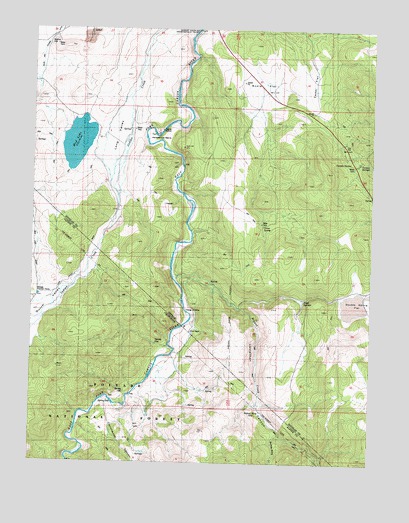
Carters Station, NV USGS Topographic Map
Click on map above to begin viewing in our Map Viewer.

This topographic map contains these locations and features:
Feature Name Type Latitude Longitude GNIS ID View Map
Barney RileyLocaleN38.7649°W119.6663°256545View Map
Barney Riley CreekStreamN38.7580°W119.6582°256546View Map
Bodie FlatFlatN38.8591°W119.6660°858971View Map
Bryant CreekStreamN38.8035°W119.6996°257554View Map
Carter Springs Census Designated PlaceCensusN38.8619°W119.6411°2583913View Map
Carters SpringsSpringN38.8370°W119.6302°859164View Map
Carters StationLocaleN38.8360°W119.6327°859165View Map
Cedar FlatFlatN38.8591°W119.6477°859191View Map
China SpringSpringN38.8184°W119.6663°859239View Map
China Spring Youth CampLocaleN38.8221°W119.6607°863028View Map
Cottonwood CanyonValleyN38.7682°W119.7216°258756View Map
Doud SpringsSpringN38.7971°W119.6511°859546View Map
Dutch ValleyValleyN38.7999°W119.7385°266665View Map
Falke and Tillman DitchCanalN38.8677°W119.7477°859689View Map
Horse Shoe Bend Dam SiteLocaleN38.8538°W119.6980°847919View Map
Horseshoe BendBendN38.8435°W119.7032°860046View Map
Hot SpringsSpringN38.7702°W119.7166°1662372View Map
Indian Valley RanchLocaleN38.8438°W119.7263°847958View Map
Leviathan CanyonValleyN38.8035°W119.6996°262422View Map
Leviathan CanyonValleyN38.8027°W119.6966°860329View Map
Long ValleyValleyN38.8613°W119.7124°860413View Map
Mud LakeLakeN38.8421°W119.7346°860672View Map
Nevada Tungsten MillLocaleN38.8369°W119.6316°855564View Map
Pinyon Dam SiteLocaleN38.8127°W119.6955°847920View Map
River RanchLocaleN38.7877°W119.6916°861124View Map
Stoddard and Jewel Jacobsen High SchoolSchoolN38.8184°W119.6662°2076259View Map
Uhalde Springmeyer Stock BridgeBridgeN38.8274°W119.6952°847864View Map
Washoe CemeteryCemeteryN38.8699°W119.7454°861903View Map
Youngs CrossingLocaleN38.7935°W119.6938°862124View Map

Note: Coordinates in the location and feature list above are referenced to NAD83 datum.


Copyright (C) 2008-2024 Ryan Niemi / Sunset Dynamics ... All Rights Reserved