TopoQuest Logo
Do you find TopoQuest useful?
Help keep TopoQuest running and adding new maps/features by donating!
Bitcoin:  19c7KJd3qBynnjoSw5npx9KScwjBe4ifkT
Litecoin:  LXs6TkuXGGXo1vDsWCkWVdjQX94eUKd6ui
Home View Maps Find Maps Find Places Resources & Links


Cebollita Peak, New Mexico Topographic Map

USGS Map Title: Cebollita Peak, NM
USGS Map MRC: 34107F7
DRG (GeoTIFF) Download: o34107f7.tif


Neighboring USGS Topographic Map Quads:


  North Pasture, NM  
34107G8
 

  Laguna Honda, NM  
34107G7
 

  Blue Mesa, NM  
34107G6
 

  Sand Canyon, NM  
34107F8
 

  Cebollita Peak, NM  
34107F7
 

  Mecate Meadow, NM  
34107F6
 

  Bonine Canyon, NM  
34107E8
 

  Wild Horse Canyon, NM  
34107E7
 

  Wiley Mesa, NM  
34107E6


Map MRC Location:

N35°
W108°
N35°
W107°
H8 H7 H6 H5 H4 H3 H2 H1
G8 G7 G6 G5 G4 G3 G2 G1
F8 F7 F6 F5 F4 F3 F2 F1
E8 E7 E6 E5 E4 E3 E2 E1
D8 D7 D6 D5 D4 D3 D2 D1
C8 C7 C6 C5 C4 C3 C2 C1
B8 B7 B6 B5 B4 B3 B2 B1
A8 A7 A6 A5 A4 A3 A2 A1
N34°
W108°
N34°
W107°

Cebollita Peak, NM USGS 1:24K Topographic Map Preview:
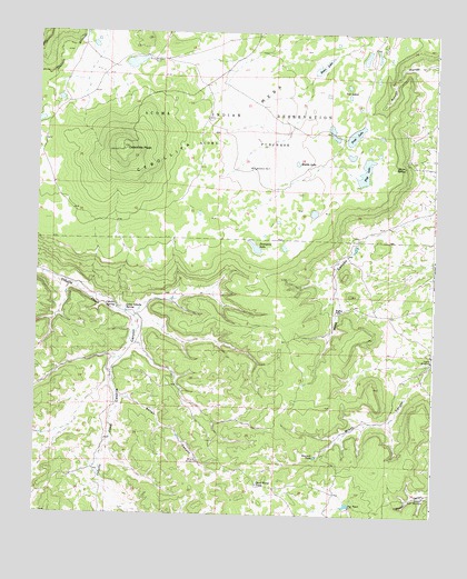
Cebollita Peak, NM USGS Topographic Map
Click on map above to begin viewing in our Map Viewer.

This topographic map contains these locations and features:
Feature Name Type Latitude Longitude GNIS ID View Map
Baker CanyonValleyN34.6548°W107.8473°885999View Map
Cebolla SpringSpringN34.6792°W107.8501°887310View Map
Cebollita MesaSummitN34.7195°W107.8473°897333View Map
Cebollita PeakSummitN34.7278°W107.8506°898273View Map
Dead Horse TankReservoirN34.6330°W107.8050°888238View Map
Flag LakeLakeN34.7144°W107.7723°889068View Map
Gibson WindmillLocaleN34.6301°W107.7528°889403View Map
Gibson WML Water WellWellN34.6301°W107.7526°918494View Map
Hughes Pl Water WellWellN34.6778°W107.7784°918731View Map
Hughes PlaceLocaleN34.6781°W107.7809°898663View Map
Jug TankReservoirN34.6278°W107.7769°890596View Map
Little Cebolla SpringSpringN34.6786°W107.8469°891120View Map
Major SpringSpringN34.7156°W107.7601°891549View Map
Middle LakeLakeN34.7163°W107.7937°891955View Map
Owsley Water WellWellN34.6653°W107.7512°919793View Map
Owsley WindmillLocaleN34.6653°W107.7509°892987View Map
Porcupine LakeLakeN34.6945°W107.8065°893414View Map
Rodeo LakeLakeN34.7413°W107.7864°894118View Map
Sawmill TankReservoirN34.6402°W107.7869°894620View Map
Trap LakeLakeN34.7237°W107.7758°895801View Map
Tub LakesLakeN34.7365°W107.7779°895871View Map
Wildcat WindmillLocaleN34.6387°W107.8237°896605View Map
Windmill Number 3LocaleN34.7425°W107.8392°898205View Map
Windmill Number 7LocaleN34.7148°W107.8067°898218View Map

Note: Coordinates in the location and feature list above are referenced to NAD83 datum.


Copyright (C) 2008-2024 Ryan Niemi / Sunset Dynamics ... All Rights Reserved