TopoQuest Logo
Do you find TopoQuest useful?
Help keep TopoQuest running and adding new maps/features by donating!
Bitcoin:  19c7KJd3qBynnjoSw5npx9KScwjBe4ifkT
Litecoin:  LXs6TkuXGGXo1vDsWCkWVdjQX94eUKd6ui
Home View Maps Find Maps Find Places Resources & Links


Cross Hill, South Carolina Topographic Map

USGS Map Title: Cross Hill, SC
USGS Map MRC: 34081C8
DRG (GeoTIFF) Download: o34081c8.tif


Neighboring USGS Topographic Map Quads:


  Laurens South, SC  
34082D1
 

  Clinton, SC  
34081D8
 

  Joanna, SC  
34081D7
 

  Waterloo, SC  
34082C1
 

  Cross Hill, SC  
34081C8
 

  Bush River, SC  
34081C7
 

  Ninety Six, SC  
34082B1
 

  Dyson, SC  
34081B8
 

  Chappells, SC  
34081B7


Map MRC Location:

N35°
W82°
N35°
W81°
H8 H7 H6 H5 H4 H3 H2 H1
G8 G7 G6 G5 G4 G3 G2 G1
F8 F7 F6 F5 F4 F3 F2 F1
E8 E7 E6 E5 E4 E3 E2 E1
D8 D7 D6 D5 D4 D3 D2 D1
C8 C7 C6 C5 C4 C3 C2 C1
B8 B7 B6 B5 B4 B3 B2 B1
A8 A7 A6 A5 A4 A3 A2 A1
N34°
W82°
N34°
W81°

Cross Hill, SC USGS 1:24K Topographic Map Preview:
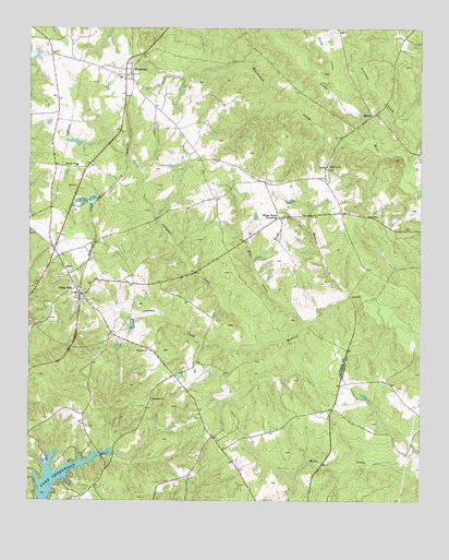
Cross Hill, SC USGS Topographic Map
Click on map above to begin viewing in our Map Viewer.

This topographic map contains these locations and features:
Feature Name Type Latitude Longitude GNIS ID View Map
Beaverdam CreekStreamN34.3449°W81.8890°1220442View Map
Bethabara CemeteryCemeteryN34.2765°W81.9615°1234747View Map
Bethabara ChurchChurchN34.2771°W81.9607°1246756View Map
Black GatePopulated PlaceN34.2507°W81.9860°1234757View Map
Black Mill (historical)LocaleN34.3549°W81.9004°1234758View Map
Campbell CreekStreamN34.2918°W81.9257°1221276View Map
Coggins School (historical)SchoolN34.2640°W81.9376°1234786View Map
Cross HillPopulated PlaceN34.3048°W81.9829°1247433View Map
Cross Hill Baptist ChurchChurchN34.3204°W81.9996°1234793View Map
Cross Hill CemeteryCemeteryN34.3198°W81.9996°1234794View Map
Cross Hill Community Fire Department Cross Hill Station 1BuildingN34.3098°W81.9865°2578285View Map
Cross Hill DivisionCivilN34.3230°W81.9924°1938243View Map
Cross Hill Police DepartmentBuildingN34.3098°W81.9865°2734252View Map
First Baptist ChurchChurchN34.3065°W81.9843°1234811View Map
GreenwoodPopulated PlaceN34.2585°W81.9751°1234836View Map
Head Springs Associate Reformed Pres Church (historical)ChurchN34.3362°W81.9290°1234839View Map
Head Springs CemeteryCemeteryN34.3365°W81.9293°1234840View Map
Hollingsworth Pond Dam D-2995DamN34.2968°W81.9665°1240218View Map
Hollingworths PondReservoirN34.2969°W81.9670°1240219View Map
Laurens County Emergency Medical Services Station 4BuildingN34.3093°W81.9865°2739644View Map
Laurens County Fire Department Cross Hill Station 2BuildingN34.2696°W81.9826°2578449View Map
Laurens County Fire Department MountvilleBuildingN34.3638°W81.9706°2578263View Map
Liberty Springs Presbyterian ChurchChurchN34.3087°W81.9904°1234878View Map
Midway SchoolSchoolN34.3387°W81.9848°1246649View Map
Mill CreekStreamN34.2976°W81.9123°1224536View Map
MiltonPopulated PlaceN34.3524°W81.8898°1246685View Map
Mount Pleasant Church (historical)ChurchN34.3021°W81.9240°1234904View Map
Mount Presbyterian ChurchChurchN34.3615°W81.9696°1234910View Map
MountvillePopulated PlaceN34.3629°W81.9676°1249752View Map
Mountville Baptist ChurchChurchN34.3629°W81.9651°1234909View Map
Mountville Census Designated PlaceCensusN34.3664°W81.9759°2403315View Map
North Campbell CreekStreamN34.2921°W81.9257°1225071View Map
North CreekStreamN34.3604°W81.9054°1225075View Map
Piedmont ChurchChurchN34.3387°W81.9048°1225409View Map
Piedmont School (historical)SchoolN34.3385°W81.9051°1234932View Map
Simmons CreekStreamN34.3376°W81.8801°1226631View Map
Spring Grove (historical)Populated PlaceN34.2668°W81.9409°1234976View Map
Thomason AirfieldAirportN34.3660°W81.9941°1251941View Map
Town of Cross HillCivilN34.3043°W81.9835°2406339View Map
Watkins CreekStreamN34.3051°W81.8976°1227437View Map
White Plains CrossroadPopulated PlaceN34.3251°W81.9201°1227999View Map
Zion Hill ChurchChurchN34.2896°W81.9659°1251561View Map

Note: Coordinates in the location and feature list above are referenced to NAD83 datum.


Copyright (C) 2008-2024 Ryan Niemi / Sunset Dynamics ... All Rights Reserved