TopoQuest Logo
Do you find TopoQuest useful?
Help keep TopoQuest running and adding new maps/features by donating!
Bitcoin:  19c7KJd3qBynnjoSw5npx9KScwjBe4ifkT
Litecoin:  LXs6TkuXGGXo1vDsWCkWVdjQX94eUKd6ui
Home View Maps Find Maps Find Places Resources & Links


Crystal Falls, Michigan Topographic Map

USGS Map Title: Crystal Falls, MI
USGS Map MRC: 46088A3
DRG (GeoTIFF) Download: o46088a3.tif


Neighboring USGS Topographic Map Quads:


  Amasa, MI  
46088B4
 

  Kelso Junction, MI  
46088B3
 

  Kiernan, MI  
46088B2
 

  Fortune Lakes, MI  
46088A4
 

  Crystal Falls, MI  
46088A3
 

  Lake Mary, MI  
46088A2
 

  Naults, MI  
45088H4
 

  Florence West, WI  
45088H3
 

  Florence East, WI  
45088H2


Map MRC Location:

N47°
W89°
N47°
W88°
H8 H7 H6 H5 H4 H3 H2 H1
G8 G7 G6 G5 G4 G3 G2 G1
F8 F7 F6 F5 F4 F3 F2 F1
E8 E7 E6 E5 E4 E3 E2 E1
D8 D7 D6 D5 D4 D3 D2 D1
C8 C7 C6 C5 C4 C3 C2 C1
B8 B7 B6 B5 B4 B3 B2 B1
A8 A7 A6 A5 A4 A3 A2 A1
N46°
W89°
N46°
W88°

Crystal Falls, MI USGS 1:24K Topographic Map Preview:
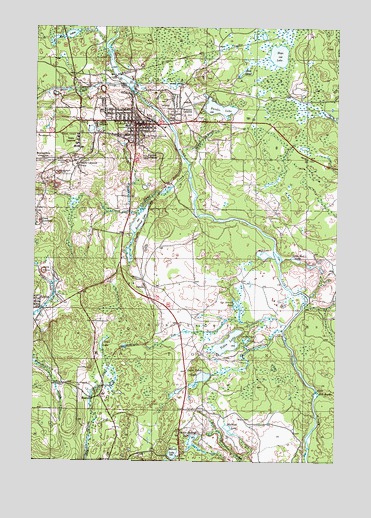
Crystal Falls, MI USGS Topographic Map
Click on map above to begin viewing in our Map Viewer.

This topographic map contains these locations and features:
Feature Name Type Latitude Longitude GNIS ID View Map
Alpha - Mastodon Township Volunteer Fire Department Station 1 HeadquartersBuildingN46.0534°W88.3373°2626919View Map
Alpha Station (historical)LocaleN46.0436°W88.3717°2129506View Map
Beaver LakeLakeN46.0025°W88.3168°620937View Map
Blaney CreekStreamN46.0858°W88.3104°621572View Map
Book MineMineN46.0547°W88.3704°621721View Map
Briar Hill CreekStreamN46.1080°W88.3362°621947View Map
Camp Buckskins CreekStreamN46.0455°W88.2626°2791365View Map
Christ United Methodist ChurchChurchN46.0956°W88.3336°2129476View Map
City of Crystal FallsCivilN46.0968°W88.3265°1626146View Map
Clinch Post Office (historical)Post OfficeN46.0861°W88.3583°2129458View Map
County SheriffBuildingN46.0968°W88.3353°2129527View Map
Crystal FallsPopulated PlaceN46.0980°W88.3340°624170View Map
Crystal Falls Family Health CenterHospitalN46.0969°W88.3542°2129466View Map
Crystal Falls Fire DepartmentBuildingN46.0964°W88.3327°2129469View Map
Crystal Falls LibraryBuildingN46.0967°W88.3303°2129471View Map
Crystal Falls Police DepartmentBuildingN46.0966°W88.3324°2129468View Map
Crystal Falls Post OfficePost OfficeN46.0953°W88.3339°2129473View Map
Crystal Falls Station (historical)LocaleN46.0986°W88.3322°2129475View Map
Crystal Manor Nursing HomeHospitalN46.0969°W88.3331°2129470View Map
Crystal View Golf CourseLocaleN46.1042°W88.3217°2129530View Map
Dunn CreekStreamN46.0836°W88.3115°625001View Map
Dunn LocationPopulated PlaceN46.0680°W88.3749°625007View Map
Dunn Post Office (historical)Post OfficeN46.0681°W88.3747°2129457View Map
Dunn Station (historical)LocaleN46.0681°W88.3744°2129456View Map
Evergreen Memorial CemeteryCemeteryN46.1000°W88.3117°2129519View Map
Faith Baptist ChurchChurchN46.0950°W88.3336°2129477View Map
Falls ClinicHospitalN46.0947°W88.3328°2129467View Map
Finn LakeLakeN46.0340°W88.3463°625967View Map
Forest Park High SchoolSchoolN46.0964°W88.3375°2129483View Map
Greater Iron County Emergency Medical Services Station 2BuildingN46.0977°W88.3593°2661942View Map
Guardian Angels ChurchChurchN46.0983°W88.3336°2129479View Map
Harbour House MuseumBuildingN46.0978°W88.3325°2129472View Map
Hope LakeLakeN46.1171°W88.2747°628569View Map
Iron County AirportAirportN46.0089°W88.2777°1623850View Map
Iron County Community HospitalHospitalN46.0969°W88.3542°2129465View Map
Iron County CourthouseBuildingN46.0967°W88.3356°2129528View Map
Iron County Historical MarkerParkN46.0967°W88.3356°2129529View Map
Iron County Medical Care FacilityHospitalN46.0939°W88.3742°2129464View Map
Kennedy LakeLakeN46.0341°W88.2946°1614906View Map
Kimball LocationPopulated PlaceN46.0880°W88.3296°1617659View Map
Lakeview Bible ChurchChurchN46.0617°W88.3394°2129478View Map
Leather Leaf LakeLakeN46.0350°W88.2869°630245View Map
Lincoln ParkParkN46.0978°W88.3186°2129474View Map
Little Bull RapidsRapidsN46.0202°W88.2579°630583View Map
Little Mud LakeLakeN46.0586°W88.2668°630700View Map
Little Tobin LakeLakeN46.0243°W88.3047°630793View Map
Lower Paint DamDamN46.0210°W88.2580°2574528View Map
Mallard LakeLakeN46.0095°W88.2941°631353View Map
MastodonPopulated PlaceN46.0183°W88.3487°1617706View Map
Mastodon Mine Post Office (historical)Post OfficeN46.0311°W88.3681°2129439View Map
Michigan Department of Natural Resources Crystal Falls Field OfficeBuildingN46.0983°W88.3598°2626858View Map
Monongahela LocationPopulated PlaceN46.0869°W88.3715°1617727View Map
Monongahela MineMineN46.0827°W88.3651°632571View Map
Mud LakeLakeN46.0594°W88.2799°633032View Map
Mud LakeLakeN46.1119°W88.2896°633036View Map
Mud LakesLakeN46.1228°W88.3607°633084View Map
Odgers LocationPopulated PlaceN46.0975°W88.3490°633944View Map
Paint River Hills CampgroundLocaleN46.1033°W88.3328°2129482View Map
PanolaPopulated PlaceN46.0494°W88.3287°1617768View Map
Panola Station (historical)LocaleN46.0494°W88.3286°2129427View Map
Railroad LakeLakeN46.0700°W88.3301°635596View Map
Runkle LakeLakeN46.1017°W88.2989°636374View Map
Runkle Lake ParkParkN46.1031°W88.3069°2129489View Map
Saint Mark's Episcopal ChurchChurchN46.0978°W88.3381°2129480View Map
Seven Springs LakeLakeN46.0064°W88.3087°637594View Map
Shafer LocationPopulated PlaceN46.0850°W88.3574°1617848View Map
Shafer MineMineN46.0863°W88.3624°637634View Map
Tim Bowers CreekStreamN46.0394°W88.2707°1614864View Map
Tim Bowers PondLakeN46.0453°W88.2912°1614865View Map
Tobin LocationPopulated PlaceN46.0925°W88.3562°1614907View Map
Township of MastodonCivilN46.0165°W88.2846°1626708View Map
United Lutheran ChurchChurchN46.0967°W88.3342°2129481View Map
Waterworks CreekStreamN46.0725°W88.3360°1615864View Map
Western LocationPopulated PlaceN46.1013°W88.3143°1616206View Map

Note: Coordinates in the location and feature list above are referenced to NAD83 datum.


Copyright (C) 2008-2024 Ryan Niemi / Sunset Dynamics ... All Rights Reserved