TopoQuest Logo
Do you find TopoQuest useful?
Help keep TopoQuest running and adding new maps/features by donating!
Bitcoin:  19c7KJd3qBynnjoSw5npx9KScwjBe4ifkT
Litecoin:  LXs6TkuXGGXo1vDsWCkWVdjQX94eUKd6ui
Home View Maps Find Maps Find Places Resources & Links


Denton, North Carolina Topographic Map

USGS Map Title: Denton, NC
USGS Map MRC: 35080F1
DRG (GeoTIFF) Download: o35080f1.tif


Neighboring USGS Topographic Map Quads:


  Lexington East, NC  
35080G2
 

  Fair Grove, NC  
35080G1
 

  Glenola, NC  
35079G8
 

  Grist Mountain, NC  
35080F2
 

  Denton, NC  
35080F1
 

  Farmer, NC  
35079F8
 

  High Rock, NC  
35080E2
 

  Handy, NC  
35080E1
 

  Eleazer, NC  
35079E8


Map MRC Location:

N36°
W81°
N36°
W80°
H8 H7 H6 H5 H4 H3 H2 H1
G8 G7 G6 G5 G4 G3 G2 G1
F8 F7 F6 F5 F4 F3 F2 F1
E8 E7 E6 E5 E4 E3 E2 E1
D8 D7 D6 D5 D4 D3 D2 D1
C8 C7 C6 C5 C4 C3 C2 C1
B8 B7 B6 B5 B4 B3 B2 B1
A8 A7 A6 A5 A4 A3 A2 A1
N35°
W81°
N35°
W80°

Denton, NC USGS 1:24K Topographic Map Preview:
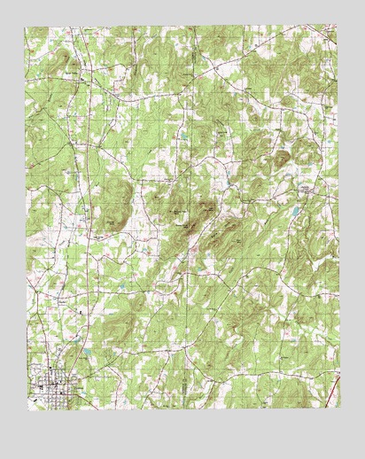
Denton, NC USGS Topographic Map
Click on map above to begin viewing in our Map Viewer.

This topographic map contains these locations and features:
Feature Name Type Latitude Longitude GNIS ID View Map
Bell MountainSummitN35.6796°W80.0412°1004182View Map
Canaan Methodist ChurchChurchN35.6690°W80.0625°1004178View Map
Cedar Springs CemeteryCemeteryN35.6804°W80.0959°1004175View Map
CidPopulated PlaceN35.7118°W80.1062°1002030View Map
Cid Methodist ChurchChurchN35.7121°W80.1042°1954548View Map
Community ChurchChurchN35.7479°W80.1003°1004168View Map
Crouse MountainSummitN35.6860°W80.0881°1004176View Map
Davidson County Emergency Medical Services Base 4BuildingN35.6307°W80.1191°2720415View Map
DentonPopulated PlaceN35.6335°W80.1159°1019952View Map
Denton Elementary SchoolSchoolN35.6326°W80.1192°1002039View Map
Denton Fire Department Station 39BuildingN35.6321°W80.1150°2638224View Map
Denton High SchoolSchoolN35.6326°W80.1192°1002040View Map
Denton Police DepartmentBuildingN35.6321°W80.1149°2769675View Map
Denton Post OfficePost OfficeN35.6337°W80.1142°2773808View Map
Fairview United Methodist ChurchChurchN35.6871°W80.1003°1004174View Map
Free Grace ChurchChurchN35.7287°W80.0373°1004169View Map
Free Wesleyan ChurchChurchN35.6574°W80.0489°1004186View Map
High Rock ChurchChurchN35.7229°W80.0048°1004172View Map
Jackson CreekPopulated PlaceN35.6957°W80.0123°1024057View Map
Jackson Creek ChurchChurchN35.7143°W80.0478°1004166View Map
Lick MountainSummitN35.6899°W80.0523°1004180View Map
Mount Ebal ChurchChurchN35.6260°W80.0681°1004187View Map
Mount Tabor ChurchChurchN35.6954°W80.0123°1004184View Map
New Jerusalem ChurchChurchN35.7318°W80.0995°1004167View Map
Old Fashion ChurchChurchN35.6412°W80.0237°1004188View Map
Pierce ChurchChurchN35.7146°W80.0095°1004171View Map
Pierces ChapelChurchN35.7271°W80.0887°1004514View Map
Piney Grove ChurchChurchN35.6924°W80.0345°1004183View Map
Pleasant Grove ChurchChurchN35.7340°W80.0564°1004165View Map
Prickly Pear MountainSummitN35.6899°W80.0664°1022081View Map
Salem ChurchChurchN35.6268°W80.0306°1004189View Map
Schoonbeck LakeReservoirN35.6885°W80.0031°999250View Map
Schoonbeck Lake DamDamN35.6885°W80.0031°999249View Map
Silver ValleyPopulated PlaceN35.7326°W80.1031°1024304View Map
Silver Valley Church of GodChurchN35.7385°W80.1023°1954550View Map
Silver Valley Elementary SchoolSchoolN35.7326°W80.1017°1023474View Map
Silver Valley Holiness ChurchChurchN35.7243°W80.1067°1954551View Map
Silver Valley Volunteer Fire Department Station 91BuildingN35.7256°W80.0995°2638181View Map
SnyderPopulated PlaceN35.6604°W80.1123°1002108View Map
Sols MountainSummitN35.6849°W80.0425°1004181View Map
South Fork Jackson CreekStreamN35.6932°W80.0150°1024722View Map
Steep Rock MountainSummitN35.6849°W80.0584°1004179View Map
Tabernacle ChurchChurchN35.7479°W80.0045°1004170View Map
Tabernacle Fire DepartmentBuildingN35.7492°W80.0091°2638587View Map
Toms Creek ChurchChurchN35.6421°W80.1000°1004185View Map
Town of DentonCivilN35.6368°W80.1108°2406375View Map
Township of EmmonsCivilN35.6909°W80.1093°1026621View Map
Walters Grove Baptist ChurchChurchN35.6990°W80.0670°1004177View Map
West Branch Lick CreekStreamN35.6801°W80.1075°1004173View Map

Note: Coordinates in the location and feature list above are referenced to NAD83 datum.


Copyright (C) 2008-2025 Ryan Niemi / Sunset Dynamics ... All Rights Reserved