TopoQuest Logo
Do you find TopoQuest useful?
Help keep TopoQuest running and adding new maps/features by donating!
Bitcoin:  19c7KJd3qBynnjoSw5npx9KScwjBe4ifkT
Litecoin:  LXs6TkuXGGXo1vDsWCkWVdjQX94eUKd6ui
Home View Maps Find Maps Find Places Resources & Links


High Rock, North Carolina Topographic Map

USGS Map Title: High Rock, NC
USGS Map MRC: 35080E2
DRG (GeoTIFF) Download: o35080e2.tif


Neighboring USGS Topographic Map Quads:


  Southmont, NC  
35080F3
 

  Grist Mountain, NC  
35080F2
 

  Denton, NC  
35080F1
 

  Gold Hill, NC  
35080E3
 

  High Rock, NC  
35080E2
 

  Handy, NC  
35080E1
 

  Richfield, NC  
35080D3
 

  New London, NC  
35080D2
 

  Badin, NC  
35080D1


Map MRC Location:

N36°
W81°
N36°
W80°
H8 H7 H6 H5 H4 H3 H2 H1
G8 G7 G6 G5 G4 G3 G2 G1
F8 F7 F6 F5 F4 F3 F2 F1
E8 E7 E6 E5 E4 E3 E2 E1
D8 D7 D6 D5 D4 D3 D2 D1
C8 C7 C6 C5 C4 C3 C2 C1
B8 B7 B6 B5 B4 B3 B2 B1
A8 A7 A6 A5 A4 A3 A2 A1
N35°
W81°
N35°
W80°

High Rock, NC USGS 1:24K Topographic Map Preview:
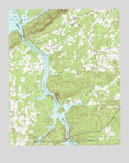
High Rock, NC USGS Topographic Map
Click on map above to begin viewing in our Map Viewer.

This topographic map contains these locations and features:
Feature Name Type Latitude Longitude GNIS ID View Map
Alleghany ChurchChurchN35.5357°W80.1251°1023791View Map
Antioch ChurchChurchN35.5082°W80.2212°1008748View Map
Bald MountainSummitN35.5463°W80.1962°1023802View Map
Bringle FerryLocaleN35.5963°W80.2331°1009611View Map
Cabin CreekStreamN35.5657°W80.2053°1023869View Map
Cedar CreekStreamN35.5888°W80.2231°1008627View Map
Chandler Grove ChurchChurchN35.5010°W80.1376°1010166View Map
Clear Springs ChurchChurchN35.5851°W80.1506°1018008View Map
Ellis CreekStreamN35.5263°W80.1889°1023961View Map
First Health of the Carolinas Emergency Medical Services Base 7BuildingN35.5010°W80.1323°2720457View Map
Flat CreekStreamN35.5468°W80.2103°1023975View Map
Flat Creek ChurchChurchN35.5563°W80.2201°1011258View Map
Flat Swamp CreekStreamN35.6154°W80.2248°1023977View Map
Healing SpringsPopulated PlaceN35.6162°W80.1781°1027407View Map
Healing Springs Fire Department Station 48BuildingN35.6163°W80.1773°2638198View Map
High RockPopulated PlaceN35.5968°W80.2212°1024036View Map
High Rock Baptist ChurchChurchN35.6001°W80.2195°1956190View Map
High Rock LakeReservoirN35.6007°W80.2351°1023730View Map
High Rock Lake DamDamN35.6007°W80.2351°1017244View Map
High Rock MountainSummitN35.6146°W80.2092°1023727View Map
Jackson HillPopulated PlaceN35.5726°W80.1501°1020921View Map
Lick CreekStreamN35.5824°W80.2064°1024086View Map
Lick Creek Baptist ChurchChurchN35.5860°W80.1914°1012847View Map
Luthers ChurchChurchN35.5160°W80.2473°1013263View Map
Millerton (historical)Populated PlaceN35.5251°W80.2456°1017391View Map
Morgan FordPopulated PlaceN35.5860°W80.2245°1021530View Map
NewsomPopulated PlaceN35.5360°W80.1876°1013951View Map
Newsom CemeteryCemeteryN35.5465°W80.1639°1018009View Map
Pleasant Grove ChurchChurchN35.5699°W80.1314°1014515View Map
PooletownPopulated PlaceN35.5907°W80.2428°1024233View Map
Pooletown Volunteer Fire Department Station 69BuildingN35.5876°W80.2440°2639677View Map
Riles CreekStreamN35.5271°W80.1967°1024263View Map
Stokes Ferry (historical)Populated PlaceN35.5074°W80.1826°1017413View Map
Stokes Ferry BridgeBridgeN35.5060°W80.1837°1015855View Map
Taylor Grove ChurchChurchN35.5143°W80.1426°1016053View Map
Township of AlleghanyCivilN35.5309°W80.1262°1026616View Map
Township of Jackson HillCivilN35.5798°W80.1253°1026624View Map
Tuckertown ReservoirReservoirN35.5168°W80.2014°1024366View Map

Note: Coordinates in the location and feature list above are referenced to NAD83 datum.


Copyright (C) 2008-2025 Ryan Niemi / Sunset Dynamics ... All Rights Reserved