TopoQuest Logo
Do you find TopoQuest useful?
Help keep TopoQuest running and adding new maps/features by donating!
Bitcoin:  19c7KJd3qBynnjoSw5npx9KScwjBe4ifkT
Litecoin:  LXs6TkuXGGXo1vDsWCkWVdjQX94eUKd6ui
Home View Maps Find Maps Find Places Resources & Links


Grist Mountain, North Carolina Topographic Map

USGS Map Title: Grist Mountain, NC
USGS Map MRC: 35080F2
DRG (GeoTIFF) Download: o35080f2.tif


Neighboring USGS Topographic Map Quads:


  Lexington West, NC  
35080G3
 

  Lexington East, NC  
35080G2
 

  Fair Grove, NC  
35080G1
 

  Southmont, NC  
35080F3
 

  Grist Mountain, NC  
35080F2
 

  Denton, NC  
35080F1
 

  Gold Hill, NC  
35080E3
 

  High Rock, NC  
35080E2
 

  Handy, NC  
35080E1


Map MRC Location:

N36°
W81°
N36°
W80°
H8 H7 H6 H5 H4 H3 H2 H1
G8 G7 G6 G5 G4 G3 G2 G1
F8 F7 F6 F5 F4 F3 F2 F1
E8 E7 E6 E5 E4 E3 E2 E1
D8 D7 D6 D5 D4 D3 D2 D1
C8 C7 C6 C5 C4 C3 C2 C1
B8 B7 B6 B5 B4 B3 B2 B1
A8 A7 A6 A5 A4 A3 A2 A1
N35°
W81°
N35°
W80°

Grist Mountain, NC USGS 1:24K Topographic Map Preview:
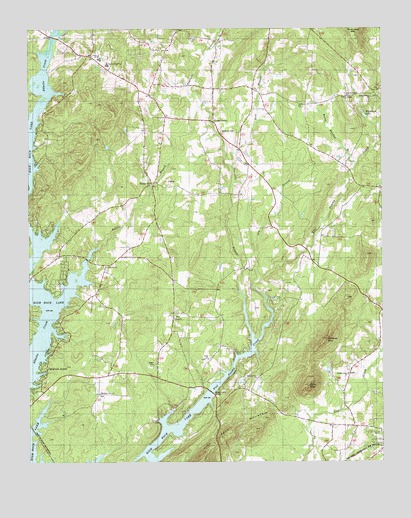
Grist Mountain, NC USGS Topographic Map
Click on map above to begin viewing in our Map Viewer.

This topographic map contains these locations and features:
Feature Name Type Latitude Longitude GNIS ID View Map
Bending BrookPopulated PlaceN35.6985°W80.2414°1023735View Map
Bethany United Methodist ChurchChurchN35.7246°W80.2009°1023725View Map
Boss BranchStreamN35.7140°W80.1773°1023845View Map
Brown Loflin BridgeBridgeN35.6454°W80.1862°1024725View Map
Buddle BranchStreamN35.6868°W80.2251°1023726View Map
Cedar GrovePopulated PlaceN35.7235°W80.1850°1023897View Map
Cedar Grove Baptist ChurchChurchN35.7196°W80.1814°1954547View Map
Central Davidson High SchoolSchoolN35.7401°W80.2231°1023736View Map
Central Davidson Junior High SchoolSchoolN35.7424°W80.2259°1023737View Map
Dry BranchStreamN35.6765°W80.1695°1023952View Map
Faith ChurchChurchN35.6549°W80.1867°1024724View Map
Floyd Baptist ChurchChurchN35.6665°W80.1984°1023728View Map
Fourmile BranchStreamN35.6607°W80.1709°1023729View Map
Grist MountainSummitN35.6471°W80.1506°1024014View Map
Grubbs Grove ChurchChurchN35.6504°W80.1370°1024729View Map
High Rock Mountain ShoresPopulated PlaceN35.6326°W80.1934°1023738View Map
Holloways Baptist ChurchChurchN35.6812°W80.2223°1023731View Map
Mountain View Baptist ChurchChurchN35.6449°W80.2251°1024171View Map
New Jerusalem United Church of ChristChurchN35.7301°W80.1370°1023732View Map
Oakwood AcresPopulated PlaceN35.6596°W80.2353°1024442View Map
Owens CemeteryCemeteryN35.6535°W80.2056°1024723View Map
Poplar CollegeLocaleN35.6921°W80.1453°1023733View Map
Rocky Meadow (historical)Populated PlaceN35.7285°W80.1475°1023739View Map
Rocky Meadow BranchStreamN35.7112°W80.1337°1024275View Map
Silver HillPopulated PlaceN35.7071°W80.2073°1024302View Map
Silver Valley Baptist ChurchChurchN35.7301°W80.1281°1024727View Map
Silver Valley Volunteer Fire Department Station 92BuildingN35.7157°W80.1481°2638704View Map
Snider MillLocaleN35.6699°W80.1448°1023740View Map
Summerville Baptist ChurchChurchN35.6493°W80.1695°1023734View Map
Township of Healing SpringCivilN35.6288°W80.1914°1026623View Map
Township of Silver HillCivilN35.7298°W80.2074°1026628View Map
Wildcat MountainSummitN35.6601°W80.1470°1024407View Map
Willomore LakeReservoirN35.7251°W80.1306°1024728View Map
Workman CemeteryCemeteryN35.7201°W80.1814°1024726View Map

Note: Coordinates in the location and feature list above are referenced to NAD83 datum.


Copyright (C) 2008-2025 Ryan Niemi / Sunset Dynamics ... All Rights Reserved