TopoQuest Logo
Do you find TopoQuest useful?
Help keep TopoQuest running and adding new maps/features by donating!
Bitcoin:  19c7KJd3qBynnjoSw5npx9KScwjBe4ifkT
Litecoin:  LXs6TkuXGGXo1vDsWCkWVdjQX94eUKd6ui
Home View Maps Find Maps Find Places Resources & Links


Donalsonville NE, Georgia Topographic Map

USGS Map Title: Donalsonville NE, GA
USGS Map MRC: 31084B7
DRG (GeoTIFF) Download: o31084b7.tif


Neighboring USGS Topographic Map Quads:


  Blakely South, GA  
31084C8
 

  Hentown, GA  
31084C7
 

  Damascus, GA  
31084C6
 

  Lucile, GA  
31084B8
 

  Donalsonville NE, GA  
31084B7
 

  Colquitt, GA  
31084B6
 

  Donalsonville West, GA  
31084A8
 

  Donalsonville East, GA  
31084A7
 

  Boykin, GA  
31084A6


Map MRC Location:

N32°
W85°
N32°
W84°
H8 H7 H6 H5 H4 H3 H2 H1
G8 G7 G6 G5 G4 G3 G2 G1
F8 F7 F6 F5 F4 F3 F2 F1
E8 E7 E6 E5 E4 E3 E2 E1
D8 D7 D6 D5 D4 D3 D2 D1
C8 C7 C6 C5 C4 C3 C2 C1
B8 B7 B6 B5 B4 B3 B2 B1
A8 A7 A6 A5 A4 A3 A2 A1
N31°
W85°
N31°
W84°

Donalsonville NE, GA USGS 1:24K Topographic Map Preview:
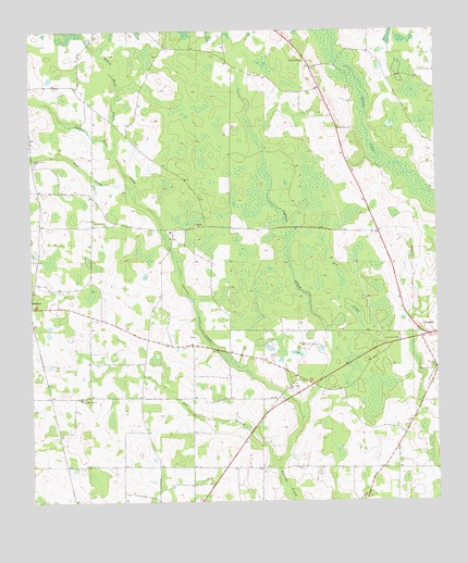
Donalsonville NE, GA USGS Topographic Map
Click on map above to begin viewing in our Map Viewer.

This topographic map contains these locations and features:
Feature Name Type Latitude Longitude GNIS ID View Map
Bush PondSwampN31.1896°W84.7577°335149View Map
Cratic CemeteryCemeteryN31.2400°W84.7660°335154View Map
Cypress CreekStreamN31.1466°W84.7921°313234View Map
Dozier (historical)Populated PlaceN31.2346°W84.7852°335155View Map
Dry CreekStreamN31.1605°W84.7769°313657View Map
Flat CreekStreamN31.2046°W84.8421°314175View Map
Flat Creek CemeteryCemeteryN31.2149°W84.8730°335320View Map
Flat Creek ChurchChurchN31.2160°W84.8733°355821View Map
Floydtown (historical)Populated PlaceN31.1338°W84.7671°335321View Map
Joe Shingler (historical)Populated PlaceN31.1974°W84.8308°335158View Map
Kaney Head CreekStreamN31.2171°W84.8485°316321View Map
Kaney Head School (historical)SchoolN31.2277°W84.8516°335166View Map
Mayhaw DivisionCivilN31.1460°W84.8232°1936397View Map
Middleton PondSwampN31.1896°W84.7705°335171View Map
Miller County Wildlife Management AreaParkN31.2021°W84.7971°335176View Map
New Salem CemeteryCemeteryN31.1546°W84.7952°335328View Map
New Salem ChurchChurchN31.1549°W84.7958°319529View Map
Newberry School (historical)SchoolN31.1524°W84.8119°335178View Map
Oak Grove Free Will Baptist ChurchChurchN31.2241°W84.7796°319765View Map
Piney PondSwampN31.1321°W84.8569°335180View Map
Pleasant Hill CemeteryCemeteryN31.1605°W84.7510°335331View Map
Porto Rico School (historical)SchoolN31.1980°W84.8602°335181View Map
Roberts CemeteryCemeteryN31.2421°W84.7902°321674View Map
Shiloh ChurchChurchN31.1982°W84.8238°322859View Map
South Mount Zion ChurchChurchN31.1524°W84.8596°323262View Map
Sow BranchStreamN31.1341°W84.7988°323321View Map
Susian Ford CreekStreamN31.2046°W84.8421°323785View Map

Note: Coordinates in the location and feature list above are referenced to NAD83 datum.


Copyright (C) 2008-2024 Ryan Niemi / Sunset Dynamics ... All Rights Reserved