TopoQuest Logo
Do you find TopoQuest useful?
Help keep TopoQuest running and adding new maps/features by donating!
Bitcoin:  19c7KJd3qBynnjoSw5npx9KScwjBe4ifkT
Litecoin:  LXs6TkuXGGXo1vDsWCkWVdjQX94eUKd6ui
Home View Maps Find Maps Find Places Resources & Links


Hentown, Georgia Topographic Map

USGS Map Title: Hentown, GA
USGS Map MRC: 31084C7
DRG (GeoTIFF) Download: o31084c7.tif


Neighboring USGS Topographic Map Quads:


  Blakely North, GA  
31084D8
 

  Bancroft, GA  
31084D7
 

  Arlington, GA  
31084D6
 

  Blakely South, GA  
31084C8
 

  Hentown, GA  
31084C7
 

  Damascus, GA  
31084C6
 

  Lucile, GA  
31084B8
 

  Donalsonville NE, GA  
31084B7
 

  Colquitt, GA  
31084B6


Map MRC Location:

N32°
W85°
N32°
W84°
H8 H7 H6 H5 H4 H3 H2 H1
G8 G7 G6 G5 G4 G3 G2 G1
F8 F7 F6 F5 F4 F3 F2 F1
E8 E7 E6 E5 E4 E3 E2 E1
D8 D7 D6 D5 D4 D3 D2 D1
C8 C7 C6 C5 C4 C3 C2 C1
B8 B7 B6 B5 B4 B3 B2 B1
A8 A7 A6 A5 A4 A3 A2 A1
N31°
W85°
N31°
W84°

Hentown, GA USGS 1:24K Topographic Map Preview:
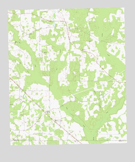
Hentown, GA USGS Topographic Map
Click on map above to begin viewing in our Map Viewer.

This topographic map contains these locations and features:
Feature Name Type Latitude Longitude GNIS ID View Map
Blue CreekStreamN31.3141°W84.8444°311545View Map
Bright Star ChurchChurchN31.3343°W84.8371°311800View Map
Bush CemeteryCemeteryN31.2949°W84.8609°312078View Map
CubaPopulated PlaceN31.2924°W84.8641°331493View Map
Cuba ChurchChurchN31.3013°W84.8635°355398View Map
Dry CreekStreamN31.2568°W84.7855°313663View Map
Dubose CemeteryCemeteryN31.2610°W84.8108°313695View Map
Dubose Methodist Church (historical)ChurchN31.2607°W84.8108°344880View Map
Early County Fire Department Cuba StationBuildingN31.2880°W84.8458°2604174View Map
Five BridgeBridgeN31.3446°W84.7752°344893View Map
George CemeteryCemeteryN31.2727°W84.8210°314557View Map
Glendale School (historical)SchoolN31.2938°W84.8052°344896View Map
HentownPopulated PlaceN31.2799°W84.8369°315334View Map
Hentown Church of ChristChurchN31.2727°W84.8433°344901View Map
Houston CemeteryCemeteryN31.2527°W84.8041°315740View Map
Liberty Hill CemeteryCemeteryN31.3600°W84.8204°344914View Map
Liberty Hill School (historical)SchoolN31.3635°W84.8135°344915View Map
Lime BranchStreamN31.3032°W84.8269°316865View Map
Macedonia ChurchChurchN31.2777°W84.8602°317526View Map
Maddox LakeReservoirN31.2985°W84.8566°342014View Map
Maddox Lake DamDamN31.2985°W84.8566°342013View Map
Mount Airy ChurchChurchN31.3452°W84.8674°318545View Map
New HopePopulated PlaceN31.2710°W84.8263°344925View Map
New Hope ChurchChurchN31.2716°W84.8266°319369View Map
New Hope School (historical)SchoolN31.2607°W84.8108°344926View Map
Oak Grove School (historical)SchoolN31.3074°W84.7688°344929View Map
Saint Johns ChurchChurchN31.3524°W84.8521°322111View Map
Saint Johns School (historical)SchoolN31.3527°W84.8521°344934View Map
Saint Marys ChurchChurchN31.2946°W84.7783°322194View Map
Spring BranchStreamN31.2771°W84.7749°323359View Map
Wamble CreekStreamN31.3099°W84.8435°324832View Map
WDKZ-FM (Blakely)TowerN31.3343°W84.8391°352638View Map
White Pond ChurchChurchN31.3368°W84.7960°325189View Map
Willis Grove ChurchChurchN31.3446°W84.7883°325395View Map

Note: Coordinates in the location and feature list above are referenced to NAD83 datum.


Copyright (C) 2008-2025 Ryan Niemi / Sunset Dynamics ... All Rights Reserved