TopoQuest Logo
Do you find TopoQuest useful?
Help keep TopoQuest running and adding new maps/features by donating!
Bitcoin:  19c7KJd3qBynnjoSw5npx9KScwjBe4ifkT
Litecoin:  LXs6TkuXGGXo1vDsWCkWVdjQX94eUKd6ui
Home View Maps Find Maps Find Places Resources & Links


Escalante, Utah Topographic Map

USGS Map Title: Escalante, UT
USGS Map MRC: 37111G5
DRG (GeoTIFF) Download: o37111g5.tif


Neighboring USGS Topographic Map Quads:


  Posy Lake, UT  
37111H6
 

  Roger Peak, UT  
37111H5
 

  Boulder Town, UT  
37111H4
 

  Wide Hollow Reservoir, UT  
37111G6
 

  Escalante, UT  
37111G5
 

  Calf Creek, UT  
37111G4
 

  Canaan Creek, UT  
37111F6
 

  Dave Canyon, UT  
37111F5
 

  Tenmile Flat, UT  
37111F4


Map MRC Location:

N38°
W112°
N38°
W111°
H8 H7 H6 H5 H4 H3 H2 H1
G8 G7 G6 G5 G4 G3 G2 G1
F8 F7 F6 F5 F4 F3 F2 F1
E8 E7 E6 E5 E4 E3 E2 E1
D8 D7 D6 D5 D4 D3 D2 D1
C8 C7 C6 C5 C4 C3 C2 C1
B8 B7 B6 B5 B4 B3 B2 B1
A8 A7 A6 A5 A4 A3 A2 A1
N37°
W112°
N37°
W111°

Escalante, UT USGS 1:24K Topographic Map Preview:
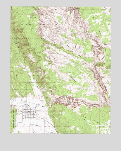
Escalante, UT USGS Topographic Map
Click on map above to begin viewing in our Map Viewer.

This topographic map contains these locations and features:
Feature Name Type Latitude Longitude GNIS ID View Map
Antone FlatFlatN37.8047°W111.5457°1438257View Map
Big FlatFlatN37.7628°W111.5199°1438668View Map
Boulder Mail TrailTrailN37.8175°W111.5488°1451195View Map
City of EscalanteCivilN37.7649°W111.6001°2410452View Map
Death HollowValleyN37.7811°W111.5054°1440327View Map
EscalantePopulated PlaceN37.7703°W111.6021°1440956View Map
Escalante CemeteryCemeteryN37.7653°W111.5832°1448385View Map
Escalante District Ranger StationLocaleN37.7711°W111.6071°1451241View Map
Escalante Elementary SchoolSchoolN37.7703°W111.5938°1448387View Map
Escalante High SchoolSchoolN37.7658°W111.5864°1448386View Map
Escalante Police DepartmentBuildingN37.7711°W111.6026°2730368View Map
Escalante Post OfficePost OfficeN37.7707°W111.6049°2769056View Map
Escalante Volunteer Fire DepartmentBuildingN37.7713°W111.6004°2627392View Map
First Baptist ChurchChurchN37.7703°W111.6005°1450591View Map
Garfield County AmbulanceBuildingN37.7716°W111.6016°2768449View Map
Hole-in-the-Rock RoadTrailN37.7511°W111.5660°1448482View Map
Mamie CreekStreamN37.7811°W111.5054°1443111View Map
Mogui Motel CampgroundLocaleN37.7708°W111.6093°1448688View Map
Phipps-Death Hollow Outstanding Natural AreaAreaN37.8167°W111.5088°1448829View Map
Pine CreekStreamN37.7775°W111.5749°1444370View Map
Potato ValleyBasinN37.7694°W111.6007°1448869View Map
Slickrock SaddleGapN37.8375°W111.5099°1445676View Map
Slickrock Saddle BenchBenchN37.8475°W111.5127°1445677View Map
Sulphur SpringSpringN37.8734°W111.5455°1446224View Map
The Church of Jesus Christ of Latter Day SaintsChurchN37.7689°W111.6007°1450745View Map
United States Forest Service Fire Station - Escalante OfficeBuildingN37.7724°W111.6148°2768498View Map

Note: Coordinates in the location and feature list above are referenced to NAD83 datum.


Copyright (C) 2008-2025 Ryan Niemi / Sunset Dynamics ... All Rights Reserved