TopoQuest Logo
Do you find TopoQuest useful?
Help keep TopoQuest running and adding new maps/features by donating!
Bitcoin:  19c7KJd3qBynnjoSw5npx9KScwjBe4ifkT
Litecoin:  LXs6TkuXGGXo1vDsWCkWVdjQX94eUKd6ui
Home View Maps Find Maps Find Places Resources & Links


Falls City, Oregon Topographic Map

USGS Map Title: Falls City, OR
USGS Map MRC: 44123G4
DRG (GeoTIFF) Download: o44123g4.tif


Neighboring USGS Topographic Map Quads:


  Laurel Mountain, OR  
44123H5
 

  Socialist Valley, OR  
44123H4
 

  Dallas, OR  
44123H3
 

  Fanno Ridge, OR  
44123G5
 

  Falls City, OR  
44123G4
 

  Airlie North, OR  
44123G3
 

  Summit, OR  
44123F5
 

  Kings Valley, OR  
44123F4
 

  Airlie South, OR  
44123F3


Map MRC Location:

N45°
W124°
N45°
W123°
H8 H7 H6 H5 H4 H3 H2 H1
G8 G7 G6 G5 G4 G3 G2 G1
F8 F7 F6 F5 F4 F3 F2 F1
E8 E7 E6 E5 E4 E3 E2 E1
D8 D7 D6 D5 D4 D3 D2 D1
C8 C7 C6 C5 C4 C3 C2 C1
B8 B7 B6 B5 B4 B3 B2 B1
A8 A7 A6 A5 A4 A3 A2 A1
N44°
W124°
N44°
W123°

Falls City, OR USGS 1:24K Topographic Map Preview:
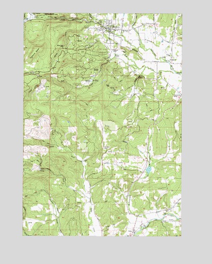
Falls City, OR USGS Topographic Map
Click on map above to begin viewing in our Map Viewer.

This topographic map contains these locations and features:
Feature Name Type Latitude Longitude GNIS ID View Map
Berry CreekStreamN44.8698°W123.4493°1162842View Map
Berry Creek FallsFallsN44.8565°W123.4701°1117554View Map
Black RockPopulated PlaceN44.8710°W123.4962°1637898View Map
Black Rock Post Office (historical)Post OfficeN44.8710°W123.4962°1164924View Map
Boughey CreekStreamN44.8521°W123.4287°1117965View Map
Bridge ParkParkN44.8669°W123.4342°2070838View Map
BridgeportPopulated PlaceN44.8485°W123.3865°1162851View Map
BumanLocaleN44.8554°W123.3929°1166746View Map
Burns CornerLocaleN44.8298°W123.3762°1162865View Map
Camp 2 (historical)LocaleN44.8723°W123.4876°1166357View Map
Camp KilowanLocaleN44.8371°W123.4462°1118521View Map
Camp TapawingoLocaleN44.8737°W123.4926°1118534View Map
Carey (historical)Populated PlaceN44.8610°W123.4109°1163515View Map
City of Falls CityCivilN44.8648°W123.4375°2410482View Map
Dutch CreekStreamN44.8698°W123.4493°1162955View Map
Dutch Creek (historical)LocaleN44.8698°W123.4490°1166359View Map
Everz CreekStreamN44.8665°W123.4373°1161044View Map
Falls CityPopulated PlaceN44.8662°W123.4359°1162976View Map
Falls City CemeteryCemeteryN44.8679°W123.4179°1163513View Map
Falls City City HallBuildingN44.8654°W123.4341°2661425View Map
Falls City Community Building and Municipal CourthouseBuildingN44.8664°W123.4338°2661426View Map
Falls City Elementary SchoolSchoolN44.8677°W123.4323°2486945View Map
Falls City Fire DepartmentBuildingN44.8664°W123.4339°2576493View Map
Falls City High SchoolSchoolN44.8655°W123.4298°2486965View Map
Falls City Odd Fellows CemeteryCemeteryN44.8651°W123.4187°1135197View Map
Falls City Post OfficePost OfficeN44.8654°W123.4374°1165241View Map
Falls City Public WorksBuildingN44.8654°W123.4341°2661483View Map
Falls City ReservoirReservoirN44.8367°W123.4478°1120613View Map
Falls City Wastewater Treatment PlantLocaleN44.8646°W123.4290°2660659View Map
Falls City Water Treatment PlantLocaleN44.8361°W123.4529°2660817View Map
Fir Grove SchoolLocaleN44.7990°W123.4384°1120729View Map
Fran Wilson Riverside ParkParkN44.8656°W123.4347°1163228View Map
Frink ReservoirReservoirN44.8668°W123.4001°1163514View Map
George Kitchen Upper ParkParkN44.8703°W123.4397°2070839View Map
Gerlinger County ParkParkN44.8721°W123.4690°1121110View Map
Glaze CreekStreamN44.8332°W123.4623°1130405View Map
Grant CreekStreamN44.8448°W123.4051°1163020View Map
Hubbard CemeteryCemeteryN44.8532°W123.4203°1122092View Map
Jahn ReservoirReservoirN44.8101°W123.4382°1130406View Map
Link (historical)LocaleN44.7587°W123.3904°1123112View Map
Link CreekStreamN44.7598°W123.3918°1134424View Map
Maddux Reservoir (historical)ReservoirN44.7730°W123.4174°1161045View Map
McTimmonds CreekStreamN44.7587°W123.4009°1124024View Map
McTimmonds ValleyValleyN44.7818°W123.4101°1163138View Map
Michael Harding ParkParkN44.8675°W123.4389°2070840View Map
Montgomery CemeteryCemeteryN44.7684°W123.3773°1163157View Map
Morgan ReservoirReservoirN44.7905°W123.4339°1163516View Map
Mount SykesSummitN44.8496°W123.4959°1127844View Map
North Fork Pedee CreekStreamN44.7712°W123.4479°1124795View Map
North Fork Teal CreekStreamN44.8382°W123.4843°1124812View Map
Oakhurst School (historical)SchoolN44.8546°W123.4312°1124922View Map
PedeePopulated PlaceN44.7535°W123.4140°1163198View Map
Pedee Post Office (historical)Post OfficeN44.7535°W123.4140°1165774View Map
Polk County Fire District 1 Station 70 PedeeBuildingN44.7536°W123.4142°2576747View Map
Rattling SpringsSpringN44.8437°W123.4462°1125847View Map
Sams CreekStreamN44.8732°W123.4923°1149016View Map
South Fork Pedee CreekStreamN44.7710°W123.4482°1127309View Map
South Fork Teal CreekStreamN44.8382°W123.4843°1127327View Map
Southwest Polk County Rural Fire Protection District Station 120BuildingN44.8663°W123.4337°2577076View Map
Steen ReservoirReservoirN44.8735°W123.4223°1163512View Map
Tater HillSummitN44.8343°W123.4337°1136816View Map
Teal CreekStreamN44.8418°W123.3812°1163299View Map
Teal SpringSpringN44.8387°W123.4484°1130404View Map
Wagner Community LibraryBuildingN44.8652°W123.4287°2661427View Map
Waymire CreekStreamN44.8562°W123.4093°1163335View Map
Wye (historical)LocaleN44.8721°W123.4904°1166369View Map

Note: Coordinates in the location and feature list above are referenced to NAD83 datum.


Copyright (C) 2008-2025 Ryan Niemi / Sunset Dynamics ... All Rights Reserved