TopoQuest Logo
Do you find TopoQuest useful?
Help keep TopoQuest running and adding new maps/features by donating!
Bitcoin:  19c7KJd3qBynnjoSw5npx9KScwjBe4ifkT
Litecoin:  LXs6TkuXGGXo1vDsWCkWVdjQX94eUKd6ui
Home View Maps Find Maps Find Places Resources & Links


Fosston East, Minnesota Topographic Map

USGS Map Title: Fosston East, MN
USGS Map MRC: 47095E6
DRG (GeoTIFF) Download: o47095e6.tif


Neighboring USGS Topographic Map Quads:


  McIntosh NE, MN  
47095F7
 

  Olga, MN  
47095F6
 

  Gonvick, MN  
47095F5
 

  Fosston West, MN  
47095E7
 

  Fosston East, MN  
47095E6
 

  Fosston SE, MN  
47095E5
 

  Mahnomen NE, MN  
47095D7
 

  Ebro NW, MN  
47095D6
 

  Ebro, MN  
47095D5


Map MRC Location:

N48°
W96°
N48°
W95°
H8 H7 H6 H5 H4 H3 H2 H1
G8 G7 G6 G5 G4 G3 G2 G1
F8 F7 F6 F5 F4 F3 F2 F1
E8 E7 E6 E5 E4 E3 E2 E1
D8 D7 D6 D5 D4 D3 D2 D1
C8 C7 C6 C5 C4 C3 C2 C1
B8 B7 B6 B5 B4 B3 B2 B1
A8 A7 A6 A5 A4 A3 A2 A1
N47°
W96°
N47°
W95°

Fosston East, MN USGS 1:24K Topographic Map Preview:
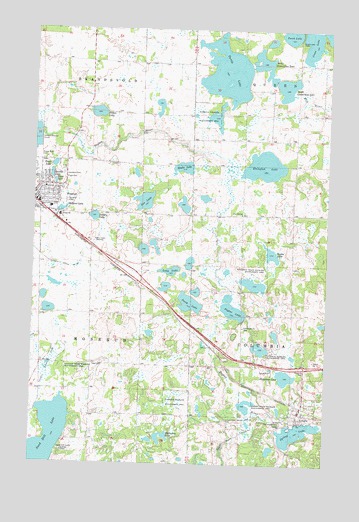
Fosston East, MN USGS Topographic Map
Click on map above to begin viewing in our Map Viewer.

This topographic map contains these locations and features:
Feature Name Type Latitude Longitude GNIS ID View Map
Bethel Assembly ChurchChurchN47.5692°W95.7358°2081450View Map
Calvary Free Lutheran ChurchChurchN47.5767°W95.7408°2081451View Map
City of LengbyCivilN47.5153°W95.6346°2395676View Map
Countryside Mobile Home ParkPopulated PlaceN47.5717°W95.7458°2081442View Map
County Ditch Number EightythreeCanalN47.5294°W95.7417°642345View Map
Cross Lake CemeteryCemeteryN47.6217°W95.6382°642489View Map
Dakota ClinicHospitalN47.5711°W95.7386°2081430View Map
East Polk Heritage CenterBuildingN47.5717°W95.7411°2081428View Map
Essentia Health AmbulanceBuildingN47.5715°W95.7394°2721250View Map
Essentia Health Fosston Clinic and HospitalHospitalN47.5713°W95.7397°2081447View Map
First English Lutheran ChurchChurchN47.5789°W95.7469°2081452View Map
First LakeLakeN47.5808°W95.7415°643655View Map
Fosston High SchoolSchoolN47.5750°W95.7475°2081448View Map
Fosston Law Enforcement CenterBuildingN47.5747°W95.7494°2081439View Map
Fosston LibraryBuildingN47.5794°W95.7456°2081441View Map
Fosston United Methodist ChurchChurchN47.5753°W95.7469°2081455View Map
Fridhem Lutheran ChurchChurchN47.5158°W95.6356°2081835View Map
Halvorson LakeLakeN47.5253°W95.6421°644594View Map
Haslie LakeLakeN47.5852°W95.6865°644711View Map
Hope Lutheran ChurchChurchN47.5792°W95.7456°2081456View Map
Horseshoe LakeLakeN47.5086°W95.6943°645240View Map
Hovland State Wildlife Management AreaParkN47.5258°W95.7409°645256View Map
Immanuel CemeteryCemeteryN47.5122°W95.6439°645360View Map
Johnson Rest HomeHospitalN47.5756°W95.7450°2081446View Map
Kingo CemeteryCemeteryN47.5822°W95.7374°646161View Map
Kingo Lutheran ChurchChurchN47.5775°W95.7497°2081457View Map
KKCQ-AM (Fosston)TowerN47.5622°W95.7253°662920View Map
KKCQ-FM (Fosston)TowerN47.5622°W95.7253°663048View Map
Landstad CemeteryCemeteryN47.5828°W95.7374°646470View Map
Lee LakeLakeN47.5754°W95.7033°646572View Map
LengbyLocaleN47.5178°W95.6361°2081831View Map
LengbyPopulated PlaceN47.5158°W95.6359°646595View Map
Lengby Lutheran ParishChurchN47.5158°W95.6356°2081834View Map
Lengby Post OfficePost OfficeN47.5146°W95.6360°2081832View Map
Lengby Rest AreaLocaleN47.5281°W95.6361°2081854View Map
Lengby State Wildlife Management AreaParkN47.5166°W95.6581°646596View Map
Long LakeLakeN47.5555°W95.6917°647103View Map
Magelssen Elementary SchoolSchoolN47.5736°W95.7425°2081449View Map
Melland LakeLakeN47.5730°W95.7379°647752View Map
Melland ParkParkN47.5717°W95.7411°2081427View Map
Midway Care CenterHospitalN47.5764°W95.7433°2081445View Map
Myhre LakeLakeN47.5603°W95.6487°648411View Map
North Connection LakeLakeN47.6159°W95.6541°648631View Map
Perch LakeLakeN47.5462°W95.6835°649294View Map
Pine Hill SchoolSchoolN47.5719°W95.6620°649462View Map
Polk County Waterfowl Production AreaParkN47.5770°W95.6530°2765456View Map
Poplar LakeLakeN47.5447°W95.6651°649649View Map
Poplar Lake CemeteryCemeteryN47.5478°W95.6600°2081326View Map
Poplar Lake ChurchChurchN47.5394°W95.6603°649650View Map
Poplar River CemeteryCemeteryN47.5875°W95.7470°649652View Map
Rosehill CemeteryCemeteryN47.5752°W95.7361°650283View Map
Sagaiigan State Wildlife Management AreaParkN47.5538°W95.6559°650469View Map
Saint Mary's ChurchChurchN47.5792°W95.7411°2081454View Map
Saint Paul Evangelical Lutheran ChurchChurchN47.5158°W95.6356°2081833View Map
Saint Pauls CemeteryCemeteryN47.5147°W95.6405°2081327View Map
Sand Hill CampLocaleN47.5041°W95.7378°651142View Map
Sand Hill ChapelChurchN47.5036°W95.7367°651143View Map
Sand Hill LakeReservoirN47.5150°W95.7470°1776291View Map
Sand Hill LakeLakeN47.5074°W95.7424°651145View Map
Sand Hill Lake DamDamN47.5150°W95.7470°1776290View Map
Second LakeLakeN47.5832°W95.7430°651823View Map
Solbery LakeLakeN47.5708°W95.7247°652233View Map
South Connection LakeLakeN47.6090°W95.6438°652286View Map
Spring LakeLakeN47.5093°W95.6373°652471View Map
Sugar Bush CreekStreamN47.5147°W95.6581°652766View Map
Third LakeLakeN47.5858°W95.7418°653136View Map
Township of RosebudCivilN47.5417°W95.7466°665460View Map
Turtle LakeLakeN47.6129°W95.6691°653382View Map
Volden LakeLakeN47.6009°W95.7235°653681View Map
Whitefish LakeLakeN47.5856°W95.6530°654102View Map

Note: Coordinates in the location and feature list above are referenced to NAD83 datum.


Copyright (C) 2008-2025 Ryan Niemi / Sunset Dynamics ... All Rights Reserved