TopoQuest Logo
Do you find TopoQuest useful?
Help keep TopoQuest running and adding new maps/features by donating!
Bitcoin:  19c7KJd3qBynnjoSw5npx9KScwjBe4ifkT
Litecoin:  LXs6TkuXGGXo1vDsWCkWVdjQX94eUKd6ui
Home View Maps Find Maps Find Places Resources & Links


Olga, Minnesota Topographic Map

USGS Map Title: Olga, MN
USGS Map MRC: 47095F6
DRG (GeoTIFF) Download: o47095f6.tif


Neighboring USGS Topographic Map Quads:


  McIntosh NE, MN  
47095F7
 

  Olga, MN  
47095F6
 

  Gonvick, MN  
47095F5
 

  Fosston West, MN  
47095E7
 

  Fosston East, MN  
47095E6
 

  Fosston SE, MN  
47095E5


Map MRC Location:

N48°
W96°
N48°
W95°
H8 H7 H6 H5 H4 H3 H2 H1
G8 G7 G6 G5 G4 G3 G2 G1
F8 F7 F6 F5 F4 F3 F2 F1
E8 E7 E6 E5 E4 E3 E2 E1
D8 D7 D6 D5 D4 D3 D2 D1
C8 C7 C6 C5 C4 C3 C2 C1
B8 B7 B6 B5 B4 B3 B2 B1
A8 A7 A6 A5 A4 A3 A2 A1
N47°
W96°
N47°
W95°

Olga, MN USGS 1:24K Topographic Map Preview:
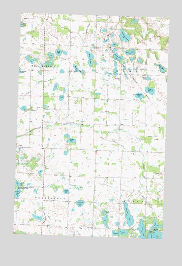
Olga, MN USGS Topographic Map
Click on map above to begin viewing in our Map Viewer.

This topographic map contains these locations and features:
Feature Name Type Latitude Longitude GNIS ID View Map
Agnes LakeLakeN47.7433°W95.7496°639230View Map
Bolme LakeLakeN47.6795°W95.7051°640354View Map
Brandsvold State Wildlife Management AreaParkN47.6511°W95.7486°640438View Map
Brandvold CemeteryCapeN47.6306°W95.7253°2081332View Map
Breed LakeLakeN47.6533°W95.7487°640451View Map
Camp LakeLakeN47.7154°W95.6416°640825View Map
Chapek LakeLakeN47.6277°W95.6607°641107View Map
County Ditch Number EightyfourCanalN47.6336°W95.7164°642346View Map
County Ditch Number FiftynineCanalN47.7066°W95.7384°642209View Map
County Ditch Number One Hundred ThirteenCanalN47.6794°W95.6711°641617View Map
County Ditch Number TwentythreeCanalN47.6536°W95.6917°641840View Map
Cross LakeLakeN47.6266°W95.6269°642485View Map
Disrud LakeLakeN47.6961°W95.7453°642824View Map
Froen ChurchChurchN47.6300°W95.6850°643969View Map
Froen Lutheran CemeteryCemeteryN47.6297°W95.6845°2081333View Map
Hamre LakeLakeN47.7192°W95.7013°644614View Map
Hedlund LakeLakeN47.7055°W95.6485°644829View Map
Johnson LakeLakeN47.7085°W95.6397°645708View Map
Lark LakeLakeN47.7212°W95.6305°646494View Map
Mamre CemeteryCemeteryN47.6964°W95.7293°647426View Map
Moe LakeLakeN47.7299°W95.6577°648009View Map
Oakland SchoolSchoolN47.6955°W95.7395°648876View Map
OlgaPopulated PlaceN47.6872°W95.6636°654858View Map
Olga Post Office (historical)Post OfficeN47.6872°W95.6633°2081363View Map
Olson LakeLakeN47.6499°W95.7068°648957View Map
Overby LakeLakeN47.6476°W95.7487°649090View Map
Perch LakeLakeN47.7259°W95.6658°649296View Map
Perch LakeLakeN47.6268°W95.6423°649297View Map
Queen CemeteryCemeteryN47.6594°W95.6406°649771View Map
Rikansrud LakeLakeN47.6386°W95.6745°650078View Map
Salem CemeteryCemeteryN47.7144°W95.6652°2081325View Map
Salem ChurchChurchN47.7144°W95.6653°651107View Map
Sawmill LakeLakeN47.6378°W95.6543°651253View Map
Schneider LakeLakeN47.7387°W95.6625°651302View Map
Sorby LakeLakeN47.7283°W95.7175°652258View Map
Tilberg County ParkParkN47.6288°W95.6334°653200View Map
Township of BrandsvoldCivilN47.6312°W95.7467°663654View Map
Township of EdenCivilN47.7174°W95.6435°664043View Map
Trinity Lutheran ChurchChurchN47.6478°W95.6333°2081469View Map
Vigoren LakeLakeN47.6434°W95.6950°653654View Map
Wold LakeLakeN47.7255°W95.6908°654300View Map
Zion CemeteryCemeteryN47.6889°W95.6961°2081324View Map
Zion ChurchChurchN47.6891°W95.6964°654487View Map

Note: Coordinates in the location and feature list above are referenced to NAD83 datum.


Copyright (C) 2008-2025 Ryan Niemi / Sunset Dynamics ... All Rights Reserved