TopoQuest Logo
Do you find TopoQuest useful?
Help keep TopoQuest running and adding new maps/features by donating!
Bitcoin:  19c7KJd3qBynnjoSw5npx9KScwjBe4ifkT
Litecoin:  LXs6TkuXGGXo1vDsWCkWVdjQX94eUKd6ui
Home View Maps Find Maps Find Places Resources & Links


Canary, Texas Topographic Map

USGS Map Title: Canary, TX
USGS Map MRC: 30096H2
DRG (GeoTIFF) Download: o30096h2.tif


Neighboring USGS Topographic Map Quads:


  Camp Creek Lake, TX  
31096A3
 

  Hilltop Lakes, TX  
31096A2
 

  Normangee, TX  
31096A1
 

  Edge, TX  
30096H3
 

  Canary, TX  
30096H2
 

  North Zulch, TX  
30096H1
 

  Kurten, TX  
30096G3
 

  Clear Lake, TX  
30096G2
 

  Iola, TX  
30096G1


Map MRC Location:

N31°
W97°
N31°
W96°
H8 H7 H6 H5 H4 H3 H2 H1
G8 G7 G6 G5 G4 G3 G2 G1
F8 F7 F6 F5 F4 F3 F2 F1
E8 E7 E6 E5 E4 E3 E2 E1
D8 D7 D6 D5 D4 D3 D2 D1
C8 C7 C6 C5 C4 C3 C2 C1
B8 B7 B6 B5 B4 B3 B2 B1
A8 A7 A6 A5 A4 A3 A2 A1
N30°
W97°
N30°
W96°

Canary, TX USGS 1:24K Topographic Map Preview:
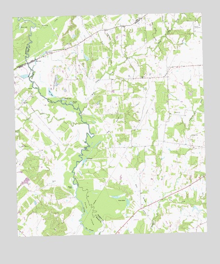
Canary, TX USGS Topographic Map
Click on map above to begin viewing in our Map Viewer.

This topographic map contains these locations and features:
Feature Name Type Latitude Longitude GNIS ID View Map
Big SloughGutN30.8777°W96.2044°1352136View Map
Bundy CrossingPopulated PlaceN30.9244°W96.2044°1379476View Map
Burns CemeteryCemeteryN30.9841°W96.2152°1353356View Map
CanaryPopulated PlaceN30.9935°W96.1783°1379499View Map
Caney IslandIslandN30.8874°W96.2036°1353746View Map
Carr LakeLakeN30.9563°W96.2261°1353856View Map
Carryall CreekStreamN30.9896°W96.1472°1353882View Map
Cottonwood CreekStreamN30.9674°W96.1891°1373236View Map
Davis LakeLakeN30.9942°W96.2455°1355708View Map
Donahoe LakeLakeN30.9505°W96.2127°1356152View Map
Dry CreekStreamN30.8938°W96.1527°1356320View Map
Duck LakeLakeN30.9174°W96.2050°1356395View Map
Keefer CemeteryCemeteryN30.9435°W96.1447°1360507View Map
Little Cedar CreekStreamN30.9385°W96.2033°1361310View Map
Long HollowValleyN30.9248°W96.1998°1361736View Map
Manning ChurchChurchN30.9516°W96.2444°1362140View Map
McDonald CreekStreamN30.9352°W96.2477°1362424View Map
Middle LakeLakeN30.9526°W96.2179°1362733View Map
Mud LakeLakeN30.9747°W96.2356°1363408View Map
Nash CemeteryCemeteryN30.9305°W96.1336°1363593View Map
Pasture LakeReservoirN30.9068°W96.2439°1857947View Map
Pasture Lake DamDamN30.9085°W96.2419°1857946View Map
Plainview CemeteryCemeteryN30.9641°W96.1669°1365376View Map
Red Bank CreekStreamN30.9821°W96.1547°1366104View Map
Running CreekStreamN30.9946°W96.2352°1375853View Map
San Antonio LakeLakeN30.9789°W96.2300°1367484View Map
Sand BranchStreamN30.8838°W96.1602°1367555View Map
Stillwagon LakeReservoirN30.8895°W96.1326°1860627View Map
Stillwagon Lake DamDamN30.8902°W96.1336°1860626View Map
Sweet LakeLakeN30.8916°W96.1773°1369471View Map
Wager LakeReservoirN30.9762°W96.2022°1860625View Map
Wager Lake DamDamN30.9752°W96.2002°1860624View Map
Weaver LakeReservoirN30.9662°W96.2430°1862838View Map
Weaver Lake DamDamN30.9669°W96.2402°1862837View Map
West Caney CreekStreamN30.9446°W96.2075°1371089View Map
Wilson LakeLakeN30.9024°W96.2132°1371721View Map

Note: Coordinates in the location and feature list above are referenced to NAD83 datum.


Copyright (C) 2008-2025 Ryan Niemi / Sunset Dynamics ... All Rights Reserved