TopoQuest Logo
Do you find TopoQuest useful?
Help keep TopoQuest running and adding new maps/features by donating!
Bitcoin:  19c7KJd3qBynnjoSw5npx9KScwjBe4ifkT
Litecoin:  LXs6TkuXGGXo1vDsWCkWVdjQX94eUKd6ui
Home View Maps Find Maps Find Places Resources & Links


North Zulch, Texas Topographic Map

USGS Map Title: North Zulch, TX
USGS Map MRC: 30096H1
DRG (GeoTIFF) Download: o30096h1.tif


Neighboring USGS Topographic Map Quads:


  Hilltop Lakes, TX  
31096A2
 

  Normangee, TX  
31096A1
 

  Leona SW, TX  
31095A8
 

  Canary, TX  
30096H2
 

  North Zulch, TX  
30096H1
 

  Madisonville, TX  
30095H8
 

  Clear Lake, TX  
30096G2
 

  Iola, TX  
30096G1
 

  Bedias, TX  
30095G8


Map MRC Location:

N31°
W97°
N31°
W96°
H8 H7 H6 H5 H4 H3 H2 H1
G8 G7 G6 G5 G4 G3 G2 G1
F8 F7 F6 F5 F4 F3 F2 F1
E8 E7 E6 E5 E4 E3 E2 E1
D8 D7 D6 D5 D4 D3 D2 D1
C8 C7 C6 C5 C4 C3 C2 C1
B8 B7 B6 B5 B4 B3 B2 B1
A8 A7 A6 A5 A4 A3 A2 A1
N30°
W97°
N30°
W96°

North Zulch, TX USGS 1:24K Topographic Map Preview:
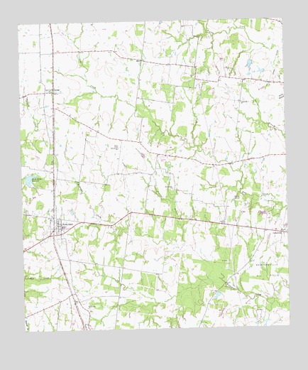
North Zulch, TX USGS Topographic Map
Click on map above to begin viewing in our Map Viewer.

This topographic map contains these locations and features:
Feature Name Type Latitude Longitude GNIS ID View Map
Chapel Hill ChurchChurchN30.9669°W96.0208°1354298View Map
CottonwoodPopulated PlaceN30.9132°W96.0030°1379601View Map
Foards BranchStreamN30.9091°W96.0494°1357523View Map
GeorgePopulated PlaceN30.9719°W96.1091°1379831View Map
LFD Ranch LakeReservoirN30.8769°W96.0569°1864282View Map
LFD Ranch Lake DamDamN30.8769°W96.0569°1864281View Map
MeccaPopulated PlaceN30.9841°W96.0669°1380171View Map
North ZulchPopulated PlaceN30.9177°W96.1083°1364203View Map
North Zulch DivisionCivilN30.9391°W96.0897°1939053View Map
North Zulch Post OfficePost OfficeN30.9164°W96.1048°2731795View Map
North Zulch ReservoirReservoirN30.9363°W96.1222°1364204View Map
North Zulch Reservoir DamDamN30.9352°W96.1236°1860628View Map
North Zulch Volunteer Fire DepartmentBuildingN30.9165°W96.1094°2552472View Map
Oxford CemeteryCemeteryN30.9174°W96.0294°1364656View Map
Rock Prairie ChurchChurchN30.9321°W96.0538°1366691View Map
Sand Prairie ChurchChurchN30.9721°W96.1116°1367637View Map
Santa Alina Ranch LakeReservoirN30.9818°W96.0162°1864277View Map
Santa Alina Ranch Lake DamDamN30.9819°W96.0152°1864276View Map
Texas No Name Number 14 DamDamN30.9785°W96.0102°1864278View Map
Texas Noname Number 2 DamDamN30.8902°W96.0336°1860630View Map
Willow Hole ChurchChurchN30.8838°W96.0952°1371655View Map

Note: Coordinates in the location and feature list above are referenced to NAD83 datum.


Copyright (C) 2008-2025 Ryan Niemi / Sunset Dynamics ... All Rights Reserved