TopoQuest Logo
Do you find TopoQuest useful?
Help keep TopoQuest running and adding new maps/features by donating!
Bitcoin:  19c7KJd3qBynnjoSw5npx9KScwjBe4ifkT
Litecoin:  LXs6TkuXGGXo1vDsWCkWVdjQX94eUKd6ui
Home View Maps Find Maps Find Places Resources & Links


Normangee, Texas Topographic Map

USGS Map Title: Normangee, TX
USGS Map MRC: 31096A1
DRG (GeoTIFF) Download: o31096a1.tif


Neighboring USGS Topographic Map Quads:


  Margie, TX  
31096B2
 

  Spring Seat, TX  
31096B1
 

  Leona, TX  
31095B8
 

  Hilltop Lakes, TX  
31096A2
 

  Normangee, TX  
31096A1
 

  Leona SW, TX  
31095A8
 

  Canary, TX  
30096H2
 

  North Zulch, TX  
30096H1
 

  Madisonville, TX  
30095H8


Map MRC Location:

N32°
W97°
N32°
W96°
H8 H7 H6 H5 H4 H3 H2 H1
G8 G7 G6 G5 G4 G3 G2 G1
F8 F7 F6 F5 F4 F3 F2 F1
E8 E7 E6 E5 E4 E3 E2 E1
D8 D7 D6 D5 D4 D3 D2 D1
C8 C7 C6 C5 C4 C3 C2 C1
B8 B7 B6 B5 B4 B3 B2 B1
A8 A7 A6 A5 A4 A3 A2 A1
N31°
W97°
N31°
W96°

Normangee, TX USGS 1:24K Topographic Map Preview:
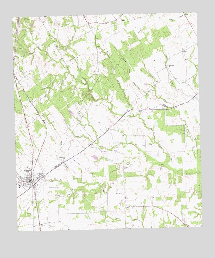
Normangee, TX USGS Topographic Map
Click on map above to begin viewing in our Map Viewer.

This topographic map contains these locations and features:
Feature Name Type Latitude Longitude GNIS ID View Map
Carter SchoolSchoolN31.0307°W96.1102°1353895View Map
Cook LakeReservoirN31.0608°W96.0891°1859031View Map
Cook Lake DamDamN31.0602°W96.0886°1859030View Map
Copeland BranchStreamN31.0657°W96.0444°1354958View Map
Deadman Hollow BranchStreamN31.0810°W96.0294°1355770View Map
East Caney CreekStreamN31.0313°W96.0072°1356588View Map
Galilee ChurchChurchN31.1221°W96.0505°1357826View Map
Hollis BranchStreamN31.0263°W96.0755°1359425View Map
Jinkins Lake DamDamN31.0685°W96.0419°1860594View Map
Middle Branch ChurchChurchN31.0944°W96.0200°1362699View Map
Moss LakeReservoirN31.0419°W96.0717°1864280View Map
Moss Lake DamDamN31.0419°W96.0686°1864279View Map
NormangeePopulated PlaceN31.0296°W96.1147°1381022View Map
Normangee City HallBuildingN31.0295°W96.1156°2754037View Map
Normangee Police DepartmentBuildingN31.0295°W96.1157°2739398View Map
Normangee Post OfficePost OfficeN31.0283°W96.1162°2732238View Map
Pond BranchStreamN31.0499°W96.0041°1365553View Map
Randolph CemeteryCemeteryN31.0357°W96.0522°1366004View Map
Rocky BranchStreamN31.0857°W96.0758°1366748View Map
Rodgers LakeLakeN31.0687°W96.0415°1366814View Map
Rodgers Prairie CemeteryCemeteryN31.0421°W96.0919°1366816View Map
Salt CreekStreamN31.0407°W96.0347°1367387View Map
Sand Prairie CemeteryCemeteryN31.0099°W96.1155°1367636View Map
Soil Conservation Service Site 1 DamDamN31.0469°W96.1219°1864025View Map
Soil Conservation Service Site 1 ReservoirReservoirN31.0472°W96.1232°1864026View Map
Tenmile CemeteryCemeteryN31.0130°W96.0475°1369704View Map
Town of NormangeeCivilN31.0300°W96.1161°2413052View Map
Union ChurchChurchN31.0132°W96.0488°1370445View Map

Note: Coordinates in the location and feature list above are referenced to NAD83 datum.


Copyright (C) 2008-2025 Ryan Niemi / Sunset Dynamics ... All Rights Reserved