TopoQuest Logo
Do you find TopoQuest useful?
Help keep TopoQuest running and adding new maps/features by donating!
Bitcoin:  19c7KJd3qBynnjoSw5npx9KScwjBe4ifkT
Litecoin:  LXs6TkuXGGXo1vDsWCkWVdjQX94eUKd6ui
Home View Maps Find Maps Find Places Resources & Links


Garvin, Oklahoma Topographic Map

USGS Map Title: Garvin, OK
USGS Map MRC: 33094H8
DRG (GeoTIFF) Download: o33094h8.tif


Neighboring USGS Topographic Map Quads:


  Wright City, OK  
34095A1
 

  Golden, OK  
34094A8
 

  Steel Junction, OK  
34094A7
 

  Millerton, OK  
33095H1
 

  Garvin, OK  
33094H8
 

  Idabel, OK  
33094H7
 

  Negley, TX  
33095G1
 

  Acworth, TX  
33094G8
 

  Idabel SE, OK  
33094G7


Map MRC Location:

N34°
W95°
N34°
W94°
H8 H7 H6 H5 H4 H3 H2 H1
G8 G7 G6 G5 G4 G3 G2 G1
F8 F7 F6 F5 F4 F3 F2 F1
E8 E7 E6 E5 E4 E3 E2 E1
D8 D7 D6 D5 D4 D3 D2 D1
C8 C7 C6 C5 C4 C3 C2 C1
B8 B7 B6 B5 B4 B3 B2 B1
A8 A7 A6 A5 A4 A3 A2 A1
N33°
W95°
N33°
W94°

Garvin, OK USGS 1:24K Topographic Map Preview:
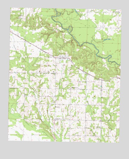
Garvin, OK USGS Topographic Map
Click on map above to begin viewing in our Map Viewer.

This topographic map contains these locations and features:
Feature Name Type Latitude Longitude GNIS ID View Map
Antioch ChurchChurchN33.9179°W94.9819°1089652View Map
Bokchito ChurchChurchN33.8898°W94.8961°1090369View Map
Campbell CreekStreamN33.9676°W94.9083°1090882View Map
Cisco SchoolSchoolN33.8884°W94.9127°1091374View Map
Coffey Valley ChurchChurchN33.9390°W94.9477°1089488View Map
Farmers Hill SchoolSchoolN33.9243°W94.9991°1092765View Map
Forest Grove Elementary SchoolSchoolN33.9260°W94.9292°1092936View Map
Forest Hill CemeteryCemeteryN33.9242°W94.9142°2712253View Map
Forest Hill ChurchChurchN33.9246°W94.9149°1092935View Map
GarvinPopulated PlaceN33.9540°W94.9424°1093138View Map
Garvin CemeteryCemeteryN33.9550°W94.9325°2760996View Map
Garvin CreekStreamN33.8904°W94.9541°1093141View Map
Garvin Post OfficePost OfficeN33.9544°W94.9404°1814184View Map
Garvin Rural Volunteer Fire Department Station 1BuildingN33.9545°W94.9379°2657072View Map
Garvin Rural Volunteer Fire Department Station 2BuildingN33.9553°W94.9413°2657071View Map
Garvin SchoolSchoolN33.9543°W94.9519°1093142View Map
Honey Grove SchoolSchoolN33.9976°W94.8777°1093888View Map
Iron Stob CornerPopulated PlaceN33.8957°W94.9474°1100529View Map
Mohawk LakeLakeN33.9718°W94.8909°1095468View Map
Oknoname 089001 DamDamN33.9418°W94.9419°1756098View Map
Oknoname 089001 ReservoirReservoirN33.9418°W94.9419°1756099View Map
Oknoname 089005 DamDamN33.9884°W94.9802°1756106View Map
Oknoname 089005 ReservoirReservoirN33.9884°W94.9802°1756107View Map
Possum Ford BendBendN33.9804°W94.9313°1096853View Map
Rattlesnake IslandIslandN33.9948°W94.9447°1097060View Map
Sunk LakeLakeN33.9977°W94.9262°1098640View Map
Sunk Lake SloughStreamN33.9962°W94.9430°1098641View Map
Town of GarvinCivilN33.9560°W94.9348°2412671View Map
Township of KirkCivilN33.9404°W94.9669°1824688View Map
Waterhole CemeteryCemeteryN33.9082°W94.9471°2712262View Map
Waterhole ChurchChurchN33.9079°W94.9466°1099419View Map
Wheelock AcademySchoolN33.9923°W94.9880°1099667View Map
Wheelock CemeteryCemeteryN33.9897°W94.9905°2712263View Map
Whitegrass-Waterhole Creeks Site 5 DamDamN33.9034°W94.9902°1757679View Map
Whitegrass-Waterhole Creeks Site 5 ReservoirReservoirN33.9034°W94.9902°1757680View Map
Whitegrass-Waterhole Creeks Site 6 DamDamN33.9251°W94.9686°1757681View Map
Whitegrass-Waterhole Creeks Site 6 ReservoirReservoirN33.9251°W94.9686°1757682View Map
Whitegrass-Waterhole Creeks Site 7 DamDamN33.9184°W94.9502°1757683View Map
Whitegrass-Waterhole Creeks Site 7 ReservoirReservoirN33.9184°W94.9486°1757684View Map
Whitegrass-Waterhole Creeks Site 8 DamDamN33.9184°W94.9452°1757685View Map
Whitegrass-Waterhole Creeks Site 8 ReservoirReservoirN33.9184°W94.9452°1757686View Map
Whitegrass-Waterhole Creeks Site 9 DamDamN33.8818°W94.9402°1757687View Map
Whitegrass-Waterhole Creeks Site 9 ReservoirReservoirN33.8818°W94.9402°1757688View Map

Note: Coordinates in the location and feature list above are referenced to NAD83 datum.


Copyright (C) 2008-2024 Ryan Niemi / Sunset Dynamics ... All Rights Reserved