TopoQuest Logo
Do you find TopoQuest useful?
Help keep TopoQuest running and adding new maps/features by donating!
Bitcoin:  19c7KJd3qBynnjoSw5npx9KScwjBe4ifkT
Litecoin:  LXs6TkuXGGXo1vDsWCkWVdjQX94eUKd6ui
Home View Maps Find Maps Find Places Resources & Links


Wright City, Oklahoma Topographic Map

USGS Map Title: Wright City, OK
USGS Map MRC: 34095A1
DRG (GeoTIFF) Download: o34095a1.tif


Neighboring USGS Topographic Map Quads:


  Sobol, OK  
34095B2
 

  Alikchi, OK  
34095B1
 

  Bear Mountain, OK  
34094B8
 

  Swink, OK  
34095A2
 

  Wright City, OK  
34095A1
 

  Golden, OK  
34094A8
 

  Kiomatia, TX  
33095H2
 

  Millerton, OK  
33095H1
 

  Garvin, OK  
33094H8


Map MRC Location:

N35°
W96°
N35°
W95°
H8 H7 H6 H5 H4 H3 H2 H1
G8 G7 G6 G5 G4 G3 G2 G1
F8 F7 F6 F5 F4 F3 F2 F1
E8 E7 E6 E5 E4 E3 E2 E1
D8 D7 D6 D5 D4 D3 D2 D1
C8 C7 C6 C5 C4 C3 C2 C1
B8 B7 B6 B5 B4 B3 B2 B1
A8 A7 A6 A5 A4 A3 A2 A1
N34°
W96°
N34°
W95°

Wright City, OK USGS 1:24K Topographic Map Preview:
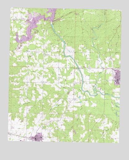
Wright City, OK USGS Topographic Map
Click on map above to begin viewing in our Map Viewer.

This topographic map contains these locations and features:
Feature Name Type Latitude Longitude GNIS ID View Map
Cypress CreekStreamN34.0498°W95.0280°1091904View Map
Doaksville (historical)Populated PlaceN34.0358°W95.0717°2452970View Map
FelkerPopulated PlaceN34.0407°W95.0522°1100409View Map
First Assembly of God ChurchChurchN34.0054°W95.0933°1790043View Map
First Baptist ChurchChurchN34.0626°W95.0019°1790142View Map
J. Leland Burkett Ministries ChurchChurchN34.0076°W95.0883°1790044View Map
Little White Oak CreekStreamN34.0501°W95.0558°1094863View Map
Moran CemeteryCemeteryN34.0832°W95.0958°1095505View Map
Mound GrovePopulated PlaceN34.0821°W95.0872°1100649View Map
Pine CreekStreamN34.1145°W95.0788°1096647View Map
Pine Creek DamDamN34.0251°W95.0786°1751396View Map
Pine Creek LakeReservoirN34.1084°W95.0780°1102174View Map
Pine Creek Volunteer Fire DepartmentBuildingN34.0846°W95.1008°2657019View Map
PlainviewPopulated PlaceN34.1134°W95.1216°1100747View Map
Rock CreekStreamN34.0701°W95.0191°1102845View Map
Rough HollowValleyN34.1126°W95.0783°1097480View Map
Sand Springs BranchStreamN34.0476°W95.0391°1097785View Map
SlimPopulated PlaceN34.0843°W95.1044°1100834View Map
Stevens CreekStreamN34.0698°W95.0483°1098525View Map
Town of ValliantCivilN34.0042°W95.0895°2413421View Map
Town of Wright CityCivilN34.0646°W95.0075°2413514View Map
United Methodist ChurchChurchN34.0040°W95.0949°1790046View Map
ValliantPopulated PlaceN34.0023°W95.0938°1099213View Map
Valliant CemeteryCemeteryN34.0053°W95.1197°1099214View Map
Valliant Church of GodChurchN34.0065°W95.0930°1790047View Map
Valliant DivisionCivilN34.0098°W95.0714°1937893View Map
Valliant Elementary SchoolSchoolN34.0042°W95.0888°1819437View Map
Valliant Fire DepartmentBuildingN34.0039°W95.0937°2657009View Map
Valliant High SchoolSchoolN34.0041°W95.0864°1819435View Map
Valliant Middle SchoolSchoolN34.0038°W95.0872°1819436View Map
Valliant Police DepartmentBuildingN34.0035°W95.0938°2757708View Map
Valliant Post OfficePost OfficeN34.0069°W95.0938°1818964View Map
Valliant Uptown CemeteryCemeteryN34.0014°W95.0886°2712261View Map
Weyerhauser Paper Company Fire DepartmentBuildingN34.0030°W95.1123°2657232View Map
White Oak CreekStreamN34.0454°W95.0408°1099707View Map
White Sands ChurchChurchN34.0559°W95.0875°1099716View Map
Wright CityPopulated PlaceN34.0601°W95.0033°1100022View Map
Wright City Elementary SchoolSchoolN34.0652°W95.0051°1790679View Map
Wright City High SchoolSchoolN34.0658°W95.0049°2713144View Map
Wright City Junior High SchoolSchoolN34.0653°W95.0048°1790523View Map
Wright City Police DepartmentBuildingN34.0685°W95.0053°2757694View Map
Wright City Post OfficePost OfficeN34.0687°W95.0063°1819194View Map
Wright City Volunteer Fire DepartmentBuildingN34.0685°W95.0049°2657059View Map

Note: Coordinates in the location and feature list above are referenced to NAD83 datum.


Copyright (C) 2008-2024 Ryan Niemi / Sunset Dynamics ... All Rights Reserved