TopoQuest Logo
Do you find TopoQuest useful?
Help keep TopoQuest running and adding new maps/features by donating!
Bitcoin:  19c7KJd3qBynnjoSw5npx9KScwjBe4ifkT
Litecoin:  LXs6TkuXGGXo1vDsWCkWVdjQX94eUKd6ui
Home View Maps Find Maps Find Places Resources & Links


Cane Hollow, Tennessee Topographic Map

USGS Map Title: Cane Hollow, TN
USGS Map MRC: 35085D7
DRG (GeoTIFF) Download: o35085d7.tif


Neighboring USGS Topographic Map Quads:


  Morrison, TN  
35085E8
 

  Viola, TN  
35085E7
 

  Irving College, TN  
35085E6
 

  Hillsboro, TN  
35085D8
 

  Cane Hollow, TN  
35085D7
 

  Altamont, TN  
35085D6
 

  Alto, TN  
35085C8
 

  Burrow Cove, TN  
35085C7
 

  Tracy City, TN  
35085C6


Map MRC Location:

N36°
W86°
N36°
W85°
H8 H7 H6 H5 H4 H3 H2 H1
G8 G7 G6 G5 G4 G3 G2 G1
F8 F7 F6 F5 F4 F3 F2 F1
E8 E7 E6 E5 E4 E3 E2 E1
D8 D7 D6 D5 D4 D3 D2 D1
C8 C7 C6 C5 C4 C3 C2 C1
B8 B7 B6 B5 B4 B3 B2 B1
A8 A7 A6 A5 A4 A3 A2 A1
N35°
W86°
N35°
W85°

Cane Hollow, TN USGS 1:24K Topographic Map Preview:
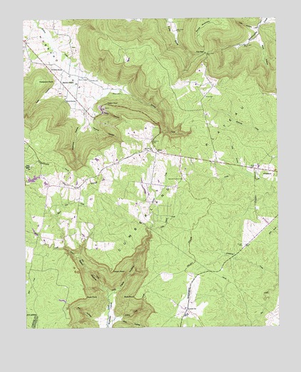
Cane Hollow, TN USGS Topographic Map
Click on map above to begin viewing in our Map Viewer.

This topographic map contains these locations and features:
Feature Name Type Latitude Longitude GNIS ID View Map
Airview CemeteryCemeteryN35.4467°W85.8119°1317698View Map
Airview ChurchChurchN35.4467°W85.8122°1304778View Map
Altamont Lookout TowerTowerN35.4351°W85.7969°1647760View Map
Basin HollowValleyN35.3888°W85.8335°1276422View Map
Billy HollowValleyN35.3781°W85.8291°1269348View Map
Boyd HollowValleyN35.4919°W85.7595°1278113View Map
Buck CreekStreamN35.3754°W85.7653°1278808View Map
Burrows Mill (historical)LocaleN35.3890°W85.8347°1309334View Map
Camp SkymontLocaleN35.4395°W85.8725°1309335View Map
Cane HollowValleyN35.3895°W85.8315°1279532View Map
Cedar HollowValleyN35.4629°W85.8408°1280078View Map
Christian SpringSpringN35.4803°W85.8613°1280527View Map
Counter PenLocaleN35.3823°W85.7955°1281379View Map
Cowen PointCapeN35.3979°W85.8325°1281470View Map
Flatbench PointRidgeN35.4745°W85.8672°1284432View Map
Hickory Creek GulfValleyN35.4690°W85.8217°2127119View Map
HixonPopulated PlaceN35.4465°W85.8094°1315243View Map
Hixon School (historical)SchoolN35.4467°W85.8125°1309348View Map
Hubbards CovePopulated PlaceN35.4820°W85.8650°1643196View Map
Hubbards Cove Baptist ChurchChurchN35.4720°W85.8547°1647185View Map
Indian Camp CreekStreamN35.4204°W85.8344°1269670View Map
Johnny CemeteryCemeteryN35.4681°W85.7855°1289506View Map
Lick HollowValleyN35.4957°W85.7593°1291229View Map
Little Laurel CreekStreamN35.4134°W85.8139°1291553View Map
Long BranchStreamN35.4376°W85.7680°1291870View Map
Lusk HollowValleyN35.4737°W85.8592°1292302View Map
Marvin ChapelChurchN35.4765°W85.8461°1292853View Map
Marvin ChapelLocaleN35.4745°W85.8564°1292855View Map
McGee SpringSpringN35.4669°W85.8545°1293306View Map
Mill HollowValleyN35.3777°W85.8393°1293867View Map
Millstone HollowValleyN35.4574°W85.8468°1294006View Map
Negro Den CreekStreamN35.3876°W85.8344°1295335View Map
Pauls PointCapeN35.3873°W85.8458°1296994View Map
Piney Creek AirportAirportN35.4232°W85.7821°2675527View Map
Rock CreekStreamN35.4073°W85.8553°1299740View Map
Roth PointCapeN35.3876°W85.8208°1300140View Map
Sanders ChapelChurchN35.4659°W85.8344°1300695View Map
Skymont Lake Dam Number OneDamN35.4367°W85.8650°1301833View Map
Skymont Lake Number OneReservoirN35.4356°W85.8706°1301834View Map
Skymount Lake Dam Number TwoDamN35.4351°W85.8650°1301832View Map
Skymount Lake Number TwoReservoirN35.4338°W85.8646°1301831View Map
Stoner MountainSummitN35.4981°W85.7828°1271528View Map
Tanyard HollowValleyN35.4579°W85.8426°1272111View Map
The GapGapN35.4862°W85.7853°1272391View Map
Tom Campbell HollowValleyN35.4892°W85.7966°1643231View Map
Winton CemeteryCemeteryN35.4701°W85.8272°1304640View Map
Wooten CemeteryCemeteryN35.4756°W85.8425°1275118View Map

Note: Coordinates in the location and feature list above are referenced to NAD83 datum.


Copyright (C) 2008-2024 Ryan Niemi / Sunset Dynamics ... All Rights Reserved