TopoQuest Logo
Do you find TopoQuest useful?
Help keep TopoQuest running and adding new maps/features by donating!
Bitcoin:  19c7KJd3qBynnjoSw5npx9KScwjBe4ifkT
Litecoin:  LXs6TkuXGGXo1vDsWCkWVdjQX94eUKd6ui
Home View Maps Find Maps Find Places Resources & Links


Hyden East, Kentucky Topographic Map

USGS Map Title: Hyden East, KY
USGS Map MRC: 37083B3
DRG (GeoTIFF) Download: o37083b3.tif


Neighboring USGS Topographic Map Quads:


  Buckhorn, KY  
37083C4
 

  Krypton, KY  
37083C3
 

  Hazard North, KY  
37083C2
 

  Hyden West, KY  
37083B4
 

  Hyden East, KY  
37083B3
 

  Hazard South, KY  
37083B2
 

  Hoskinston, KY  
37083A4
 

  Cutshin, KY  
37083A3
 

  Leatherwood, KY  
37083A2


Map MRC Location:

N38°
W84°
N38°
W83°
H8 H7 H6 H5 H4 H3 H2 H1
G8 G7 G6 G5 G4 G3 G2 G1
F8 F7 F6 F5 F4 F3 F2 F1
E8 E7 E6 E5 E4 E3 E2 E1
D8 D7 D6 D5 D4 D3 D2 D1
C8 C7 C6 C5 C4 C3 C2 C1
B8 B7 B6 B5 B4 B3 B2 B1
A8 A7 A6 A5 A4 A3 A2 A1
N37°
W84°
N37°
W83°

Hyden East, KY USGS 1:24K Topographic Map Preview:
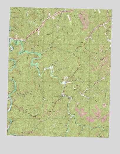
Hyden East, KY USGS Topographic Map
Click on map above to begin viewing in our Map Viewer.

This topographic map contains these locations and features:
Feature Name Type Latitude Longitude GNIS ID View Map
Aces BranchStreamN37.2068°W83.3460°510207View Map
AvawamPopulated PlaceN37.2245°W83.2752°510328View Map
Avawam Post OfficePost OfficeN37.2357°W83.2589°2557168View Map
Avawam SchoolSchoolN37.2284°W83.2735°510329View Map
Bailey BranchStreamN37.1668°W83.2838°510342View Map
Bailey Branch SchoolSchoolN37.1637°W83.2743°510344View Map
Baker ForkStreamN37.2487°W83.3543°510359View Map
Banger BranchStreamN37.1670°W83.3491°510382View Map
Bear ForkStreamN37.1706°W83.2555°510465View Map
Beech Oak BranchStreamN37.2476°W83.3080°510525View Map
Betty BranchStreamN37.2065°W83.3516°510582View Map
Big BranchStreamN37.1273°W83.3027°510629View Map
Big Branch SchoolSchoolN37.1268°W83.3052°510630View Map
Big Creek Elementary SchoolSchoolN37.2348°W83.2588°516820View Map
Big Peavine BranchStreamN37.2123°W83.3243°510684View Map
Big Two BranchStreamN37.1823°W83.2566°510707View Map
Big Willard SchoolSchoolN37.2484°W83.3071°510709View Map
Boar BranchStreamN37.2309°W83.2560°510815View Map
Brewer BranchStreamN37.1834°W83.3207°510902View Map
Briar Fork ChurchChurchN37.2453°W83.2946°2557174View Map
Brown ChapelChurchN37.1631°W83.3080°510946View Map
Browning ForkStreamN37.1712°W83.2577°510955View Map
Browning SchoolSchoolN37.1631°W83.2505°510956View Map
Bubbyroot BranchStreamN37.2497°W83.3175°2557176View Map
Buzzard BranchStreamN37.2468°W83.2930°511104View Map
Camp BranchStreamN37.1756°W83.2752°511143View Map
Cane BranchStreamN37.1812°W83.2630°511178View Map
Caudill ForkStreamN37.1640°W83.2766°511254View Map
Collins BranchStreamN37.1329°W83.2574°511472View Map
Coon Creek Post Office (historical)Post OfficeN37.1463°W83.2935°2363121View Map
Creech CemeteryCemeteryN37.1656°W83.3049°511630View Map
Cutshin CreekStreamN37.2195°W83.3749°511693View Map
Cutshin Post Office (historical)Post OfficeN37.1926°W83.3214°2363123View Map
Cutshin Volunteer Fire Department Station 2BuildingN37.1328°W83.2557°2637235View Map
Cutship ChurchChurchN37.1634°W83.2971°511694View Map
Dark HollowValleyN37.2494°W83.3493°511719View Map
Davis BranchStreamN37.1437°W83.3407°511735View Map
Davis HollowValleyN37.1639°W83.2534°511741View Map
Days CemeteryCemeteryN37.1356°W83.2585°511749View Map
Deep Ford BranchStreamN37.1945°W83.3460°511763View Map
Dicks BranchStreamN37.1345°W83.2585°511808View Map
Dixon BottomFlatN37.1456°W83.2960°2363128View Map
Dixon BranchStreamN37.1481°W83.2991°511829View Map
Dixon Branch SchoolSchoolN37.1473°W83.2982°511832View Map
Dixon CemeteryCemeteryN37.1629°W83.2966°511833View Map
Ellis BranchStreamN37.1929°W83.3674°512051View Map
Flackey BranchStreamN37.1843°W83.3352°512179View Map
Flackey SchoolSchoolN37.1715°W83.3335°512180View Map
Frontier School of Midwifery and Family NursingSchoolN37.1268°W83.3641°2363133View Map
Grassy (historical)Populated PlaceN37.2476°W83.3537°2363136View Map
Hendrix (historical)Populated PlaceN37.1803°W83.2637°2363143View Map
Hendrix CemeteryCemeteryN37.1837°W83.2571°512650View Map
Hendrix School (historical)SchoolN37.1810°W83.2637°2363144View Map
Hensley BranchStreamN37.1359°W83.3005°512667View Map
Horseshoe BranchStreamN37.1640°W83.2507°512803View Map
Hurricane CemeteryCemeteryN37.1445°W83.3241°512863View Map
Hurricane SchoolSchoolN37.1337°W83.3396°512872View Map
Hurts CreekStreamN37.1554°W83.3702°512877View Map
HydenPopulated PlaceN37.1609°W83.3732°512880View Map
Hyden Fire DepartmentBuildingN37.1543°W83.3694°2636413View Map
Hyden Police DepartmentBuildingN37.1620°W83.3742°2767407View Map
Hyden Post OfficePost OfficeN37.1642°W83.3746°2362735View Map
Indian Grave BranchStreamN37.2120°W83.3260°512913View Map
Jacks Point Lookout TowerTowerN37.2254°W83.3243°517192View Map
Leadmine BranchStreamN37.1781°W83.2952°513277View Map
Leslie County Sheriff's OfficeBuildingN37.1625°W83.3740°2767764View Map
Lewis BranchStreamN37.2137°W83.3596°513354View Map
Lewis CemeteryCemeteryN37.1601°W83.3721°513360View Map
Lick BranchStreamN37.1515°W83.3574°513382View Map
Lick ForkStreamN37.1323°W83.2538°513410View Map
Little Beech (historical)Populated PlaceN37.2410°W83.3014°2557173View Map
Little Peavine BranchStreamN37.2137°W83.3241°513510View Map
Long BranchStreamN37.2448°W83.2927°513594View Map
Looney BranchStreamN37.1759°W83.2943°513635View Map
Lower Hendrix SchoolSchoolN37.1743°W83.2682°513695View Map
Lower Jones ForkStreamN37.2379°W83.3524°513699View Map
Lower MacIntosh SchoolSchoolN37.2062°W83.3338°513704View Map
Lower McIntosh (historical)Populated PlaceN37.2065°W83.3329°2362743View Map
Lower Polls Creek SchoolSchoolN37.1334°W83.2577°513709View Map
Lower Wooton SchoolSchoolN37.1920°W83.3238°513723View Map
MacIntosh CreekStreamN37.2051°W83.3374°513745View Map
Mad Dog Post Office (historical)Post OfficeN37.2058°W83.3389°2362746View Map
Maggard BranchStreamN37.1931°W83.3216°513758View Map
Meetinghouse BranchStreamN37.1879°W83.3207°513899View Map
Mudlick ForkStreamN37.2229°W83.2760°514150View Map
Muncy CreekStreamN37.1318°W83.3732°514159View Map
Muncy SchoolSchoolN37.1831°W83.3032°516814View Map
Oldhouse BranchStreamN37.2456°W83.3746°514343View Map
Orchard Post Office (historical)Post OfficeN37.1752°W83.2701°2362758View Map
Owlsnest BranchStreamN37.1698°W83.3663°514400View Map
Pace BranchStreamN37.1615°W83.3299°514408View Map
Persimmon HollowValleyN37.2354°W83.3449°514502View Map
Pied BranchStreamN37.2043°W83.3618°514538View Map
Pleasure Woods BranchStreamN37.2168°W83.3613°514660View Map
Polls CreekStreamN37.1348°W83.2816°514679View Map
Polly Morrill BranchStreamN37.2295°W83.3735°514684View Map
Poundmill BranchStreamN37.1651°W83.3088°514744View Map
Preston ForkStreamN37.1779°W83.3030°514760View Map
Raccoon CemeteryCemeteryN37.1287°W83.3032°514815View Map
Raccoon CreekStreamN37.1459°W83.2952°514817View Map
Right Fork Big CreekStreamN37.2354°W83.2591°514929View Map
Road ForkPost OfficeN37.2384°W83.3136°2557170View Map
Roberts CemeteryCemeteryN37.1654°W83.3582°515001View Map
Rockhouse BranchStreamN37.1659°W83.3091°515040View Map
Rockhouse CreekStreamN37.1659°W83.3724°515039View Map
Rough BranchStreamN37.1462°W83.3480°515124View Map
Roundhole BranchStreamN37.1520°W83.3577°515134View Map
Saw BranchStreamN37.1615°W83.2977°515263View Map
Saw Branch ChurchChurchN37.1640°W83.2971°516815View Map
Second ForkStreamN37.1754°W83.2705°515316View Map
Skeens CemeteryCemeteryN37.1570°W83.3193°515450View Map
SmilaxPopulated PlaceN37.1356°W83.2821°515500View Map
Smilax Post OfficePost OfficeN37.1358°W83.2811°2362774View Map
Smilax SchoolSchoolN37.1323°W83.2824°515501View Map
Steepfield ForkStreamN37.2228°W83.2762°2557137View Map
Tar Kiln BranchStreamN37.1493°W83.3546°515863View Map
ToulousePopulated PlaceN37.1767°W83.3269°2092522View Map
Toulouse Post Office (historical)Post OfficeN37.2487°W83.3540°2362779View Map
Upper Jones ForkStreamN37.2359°W83.3502°516136View Map
Upper MacIntosh SchoolSchoolN37.2059°W83.2966°516140View Map
WendoverPopulated PlaceN37.1265°W83.3627°516270View Map
Wendover Post OfficePost OfficeN37.1269°W83.3633°2362785View Map
Whitaker (historical)Populated PlaceN37.2093°W83.2574°2557136View Map
Winding Star HollowValleyN37.1489°W83.3527°516420View Map
Wooten Fire and RescueBuildingN37.1648°W83.3040°2636312View Map
Wooten Post Office (historical)Post OfficeN37.1789°W83.3011°2362790View Map
WootonPopulated PlaceN37.1790°W83.3021°516481View Map
Wooton CreekStreamN37.1779°W83.3043°516483View Map

Note: Coordinates in the location and feature list above are referenced to NAD83 datum.


Copyright (C) 2008-2025 Ryan Niemi / Sunset Dynamics ... All Rights Reserved