TopoQuest Logo
Do you find TopoQuest useful?
Help keep TopoQuest running and adding new maps/features by donating!
Bitcoin:  19c7KJd3qBynnjoSw5npx9KScwjBe4ifkT
Litecoin:  LXs6TkuXGGXo1vDsWCkWVdjQX94eUKd6ui
Home View Maps Find Maps Find Places Resources & Links


Buckhorn, Kentucky Topographic Map

USGS Map Title: Buckhorn, KY
USGS Map MRC: 37083C4
DRG (GeoTIFF) Download: o37083c4.tif


Neighboring USGS Topographic Map Quads:


  Cowcreek, KY  
37083D5
 

  Canoe, KY  
37083D4
 

  Haddix, KY  
37083D3
 

  Mistletoe, KY  
37083C5
 

  Buckhorn, KY  
37083C4
 

  Krypton, KY  
37083C3
 

  Big Creek, KY  
37083B5
 

  Hyden West, KY  
37083B4
 

  Hyden East, KY  
37083B3


Map MRC Location:

N38°
W84°
N38°
W83°
H8 H7 H6 H5 H4 H3 H2 H1
G8 G7 G6 G5 G4 G3 G2 G1
F8 F7 F6 F5 F4 F3 F2 F1
E8 E7 E6 E5 E4 E3 E2 E1
D8 D7 D6 D5 D4 D3 D2 D1
C8 C7 C6 C5 C4 C3 C2 C1
B8 B7 B6 B5 B4 B3 B2 B1
A8 A7 A6 A5 A4 A3 A2 A1
N37°
W84°
N37°
W83°

Buckhorn, KY USGS 1:24K Topographic Map Preview:
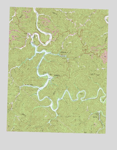
Buckhorn, KY USGS Topographic Map
Click on map above to begin viewing in our Map Viewer.

This topographic map contains these locations and features:
Feature Name Type Latitude Longitude GNIS ID View Map
Abner ForkStreamN37.3095°W83.4971°516577View Map
Aims CemeteryCemeteryN37.3576°W83.4618°516631View Map
Anderson BranchStreamN37.3426°W83.4474°510264View Map
Bear ForkStreamN37.3148°W83.4863°510464View Map
BeechPopulated PlaceN37.3698°W83.4288°510509View Map
Big ForkStreamN37.3676°W83.3982°510657View Map
Big Hill (historical)Populated PlaceN37.3534°W83.4865°2557370View Map
Bowling BranchStreamN37.3029°W83.4466°510873View Map
Bowling Creek SchoolSchoolN37.3748°W83.4432°510875View Map
Bowlingtown (historical)Populated PlaceN37.3095°W83.4527°510877View Map
Bowlingtown Post Office (historical)Post OfficeN37.3065°W83.4601°2557282View Map
Bowlingtown School (historical)SchoolN37.3080°W83.4493°2557287View Map
Buck BranchStreamN37.3526°W83.4619°510995View Map
Buck ForkStreamN37.2576°W83.4441°516576View Map
BuckhornPopulated PlaceN37.3487°W83.4763°511025View Map
Buckhorn DamDamN37.3406°W83.4702°511026View Map
Buckhorn DivisionCivilN37.3159°W83.4796°1936896View Map
Buckhorn LakeReservoirN37.2841°W83.4066°511027View Map
Buckhorn Lake State Resort ParkParkN37.3165°W83.4346°516632View Map
Buckhorn Presbyterian ChurchChurchN37.3472°W83.4756°2557353View Map
Buckhorn Volunteer Fire DepartmentBuildingN37.3491°W83.4755°2636521View Map
Cam Johnson BranchStreamN37.3673°W83.4632°511139View Map
Camp BranchStreamN37.2934°W83.4249°511144View Map
City of BuckhornCivilN37.3461°W83.4693°2403947View Map
Coal BranchStreamN37.2915°W83.4091°511435View Map
Coal HollowValleyN37.2904°W83.4851°511439View Map
Coneva Railroad Station (historical)LocaleN37.3358°W83.3793°2557339View Map
ConfluencePopulated PlaceN37.2698°W83.3841°511495View Map
Confluence Post Office (historical)Post OfficeN37.2693°W83.3842°2363119View Map
Couch BranchStreamN37.2951°W83.3810°511572View Map
Courthouse ForkStreamN37.2856°W83.4885°511577View Map
Cow BranchStreamN37.3201°W83.4819°511586View Map
Deaton CemeteryCemeteryN37.3398°W83.4555°516633View Map
Duff ForkStreamN37.3709°W83.4291°511942View Map
Elkhorn CreekStreamN37.2720°W83.4388°512048View Map
Eversole BranchStreamN37.3056°W83.4596°512102View Map
Feb ForkStreamN37.3287°W83.4366°512141View Map
Gay Post Office (historical)Post OfficeN37.2912°W83.4616°2363134View Map
Gays CreekPopulated PlaceN37.3281°W83.4277°512293View Map
Gays CreekStreamN37.3293°W83.4513°512294View Map
Gays Creek Post Office (historical)Post OfficeN37.3285°W83.4376°2557335View Map
Isaac ForkStreamN37.2643°W83.4385°512928View Map
John ForkStreamN37.3243°W83.4252°513029View Map
Johnson (historical)Populated PlaceN37.3661°W83.4491°2557380View Map
Johnson CemeteryCemeteryN37.3620°W83.4635°516630View Map
Johnson ChurchChurchN37.3704°W83.4655°513046View Map
Kay ForkStreamN37.3487°W83.3838°513098View Map
Langdon BranchStreamN37.2959°W83.3832°513203View Map
Langdon KnobSummitN37.3090°W83.3877°513204View Map
Laurel PointLocaleN37.3487°W83.4742°2557365View Map
Leatherwood Boat RampsLocaleN37.2962°W83.4696°513281View Map
Leatherwood ChurchChurchN37.2725°W83.4951°2557197View Map
Leatherwood CreekStreamN37.2945°W83.4605°513283View Map
Leatherwood SchoolSchoolN37.2729°W83.4946°513287View Map
Left Fork Elkhorn CreekStreamN37.2606°W83.4457°513311View Map
Lige Lick BranchStreamN37.3156°W83.3802°513420View Map
Lonesome HollowValleyN37.3134°W83.4921°513581View Map
Lower Leatherwood (historical)Populated PlaceN37.2734°W83.4946°2557199View Map
Lower Violet HollowValleyN37.2822°W83.4887°513721View Map
Lynn BranchStreamN37.3201°W83.4796°513736View Map
Mary Breckinridge Memorial ParkParkN37.2670°W83.3841°516634View Map
Meetinghouse BranchStreamN37.3248°W83.4549°513900View Map
Mill HollowValleyN37.2881°W83.4849°513993View Map
Miller BranchStreamN37.3620°W83.3755°514003View Map
Miller Branch SchoolSchoolN37.3598°W83.3777°514005View Map
Millstone BranchStreamN37.2556°W83.4541°514020View Map
Mosley BendBendN37.2851°W83.3785°498661View Map
Mud LickStreamN37.2729°W83.4946°514132View Map
Mudlick BranchStreamN37.3151°W83.3866°514146View Map
Old Field BranchStreamN37.2973°W83.4799°514318View Map
Opossum BendBendN37.2895°W83.4071°514363View Map
Otter CreekLocaleN37.3167°W83.4845°2557326View Map
Otter CreekStreamN37.3293°W83.4666°514385View Map
Otter Creek SchoolSchoolN37.3090°W83.4980°514388View Map
Polly Johnson BranchStreamN37.3637°W83.4655°514683View Map
Right Fork Leatherwood CreekStreamN37.2787°W83.4938°514945View Map
Rockhouse ForkStreamN37.3734°W83.4357°515047View Map
Rush CreekStreamN37.2773°W83.4460°515146View Map
SaulPopulated PlaceN37.2726°W83.4955°515260View Map
Saul Post Office (historical)Post OfficeN37.2784°W83.4946°2557212View Map
Scalf BranchStreamN37.2962°W83.4771°515280View Map
Schoolhouse BranchStreamN37.3454°W83.4752°515286View Map
ShoalLocaleN37.2681°W83.4344°515363View Map
Shoal Post Office (historical)Post OfficeN37.2679°W83.4354°2362768View Map
Shoal School (historical)SchoolN37.2672°W83.4353°2362769View Map
Smith BranchStreamN37.3231°W83.4727°515504View Map
Spicer ForkStreamN37.3348°W83.4316°515594View Map
Spring BranchStreamN37.2826°W83.4055°515605View Map
Squabble CreekStreamN37.3459°W83.4691°515639View Map
Stable BranchStreamN37.2945°W83.4844°515643View Map
Stable ForkStreamN37.2615°W83.4057°515645View Map
Stable ForkStreamN37.3268°W83.4280°515646View Map
Strong Branch SchoolSchoolN37.3520°W83.3755°515762View Map
Sweden ForkStreamN37.3245°W83.4157°515829View Map
Tantrough ForkStreamN37.2840°W83.4310°515856View Map
Trace BranchStreamN37.2681°W83.4369°516000View Map
Trace ForkStreamN37.2701°W83.3930°516013View Map
Turkey BranchStreamN37.2873°W83.4624°516041View Map
Upper Violet HollowValleyN37.2806°W83.4892°516163View Map
Wharton Post Office (historical)Post OfficeN37.3667°W83.4651°2557381View Map
Wilder BranchStreamN37.2709°W83.3830°516369View Map
Wilder Branch SchoolSchoolN37.2710°W83.3792°2362788View Map

Note: Coordinates in the location and feature list above are referenced to NAD83 datum.


Copyright (C) 2008-2025 Ryan Niemi / Sunset Dynamics ... All Rights Reserved