TopoQuest Logo
Do you find TopoQuest useful?
Help keep TopoQuest running and adding new maps/features by donating!
Bitcoin:  19c7KJd3qBynnjoSw5npx9KScwjBe4ifkT
Litecoin:  LXs6TkuXGGXo1vDsWCkWVdjQX94eUKd6ui
Home View Maps Find Maps Find Places Resources & Links


Hyden West, Kentucky Topographic Map

USGS Map Title: Hyden West, KY
USGS Map MRC: 37083B4
DRG (GeoTIFF) Download: o37083b4.tif


Neighboring USGS Topographic Map Quads:


  Mistletoe, KY  
37083C5
 

  Buckhorn, KY  
37083C4
 

  Krypton, KY  
37083C3
 

  Big Creek, KY  
37083B5
 

  Hyden West, KY  
37083B4
 

  Hyden East, KY  
37083B3
 

  Creekville, KY  
37083A5
 

  Hoskinston, KY  
37083A4
 

  Cutshin, KY  
37083A3


Map MRC Location:

N38°
W84°
N38°
W83°
H8 H7 H6 H5 H4 H3 H2 H1
G8 G7 G6 G5 G4 G3 G2 G1
F8 F7 F6 F5 F4 F3 F2 F1
E8 E7 E6 E5 E4 E3 E2 E1
D8 D7 D6 D5 D4 D3 D2 D1
C8 C7 C6 C5 C4 C3 C2 C1
B8 B7 B6 B5 B4 B3 B2 B1
A8 A7 A6 A5 A4 A3 A2 A1
N37°
W84°
N37°
W83°

Hyden West, KY USGS 1:24K Topographic Map Preview:
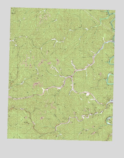
Hyden West, KY USGS Topographic Map
Click on map above to begin viewing in our Map Viewer.

This topographic map contains these locations and features:
Feature Name Type Latitude Longitude GNIS ID View Map
Asher BranchStreamN37.1826°W83.3821°510313View Map
Begley CemeteryCemeteryN37.1504°W83.3993°510533View Map
Begley's Post Office (historical)Post OfficeN37.2192°W83.3936°2363109View Map
Big BranchStreamN37.1856°W83.4346°510615View Map
Big ForkStreamN37.2309°W83.4066°510656View Map
Big Lute BranchStreamN37.1495°W83.4016°510678View Map
Bolling BranchStreamN37.1870°W83.4396°510835View Map
Bull CreekStreamN37.2204°W83.3757°511046View Map
Bullskin ForkStreamN37.2134°W83.4705°511059View Map
Buzzard RoostSummitN37.2495°W83.4024°511115View Map
Cane ForkStreamN37.1495°W83.4724°511195View Map
City of HydenCivilN37.1619°W83.3779°2404752View Map
Couch BranchStreamN37.1873°W83.4657°511571View Map
Couch CemeteryCemeteryN37.1693°W83.4757°511573View Map
Country High SchoolSchoolN37.1461°W83.3789°2091865View Map
Cucumber BranchStreamN37.2193°W83.4432°511672View Map
Davidson ForkStreamN37.1743°W83.4377°511733View Map
Devils Jump BranchStreamN37.2323°W83.4146°511800View Map
Dry Hill Post Office (historical)Post OfficeN37.2214°W83.3775°2363129View Map
DryhillPopulated PlaceN37.2220°W83.3774°511937View Map
Fishtrap BranchStreamN37.2315°W83.3757°512173View Map
Gibson BranchStreamN37.2190°W83.4988°512303View Map
Hals Fork School (historical)SchoolN37.1527°W83.4830°2363138View Map
Hell for Certain CreekStreamN37.2459°W83.3816°512638View Map
Hollins ForkStreamN37.1740°W83.4971°494397View Map
Hosea Post Office (historical)Post OfficeN37.1539°W83.4874°2362733View Map
Hoskins BranchStreamN37.2143°W83.4927°512805View Map
Hyden DivisionCivilN37.1769°W83.4328°1937070View Map
Jacks ForkStreamN37.2468°W83.4641°512962View Map
JasonPopulated PlaceN37.1784°W83.4835°512978View Map
Jason Post Office (historical)Post OfficeN37.1786°W83.4835°2362738View Map
Jasons BranchStreamN37.1512°W83.3935°512980View Map
Johnson BranchStreamN37.1809°W83.4957°513042View Map
Jones BranchStreamN37.1876°W83.4657°513058View Map
KaliopiPopulated PlaceN37.2334°W83.4166°513093View Map
Laurel CreekStreamN37.1309°W83.4366°513240View Map
Leffew BranchStreamN37.1370°W83.4921°513297View Map
Left Fork Rockhouse CreekStreamN37.1343°W83.4410°513324View Map
Licklog ForkStreamN37.2473°W83.4582°513418View Map
Little Asher BranchStreamN37.1976°W83.4016°513447View Map
Long BranchStreamN37.2376°W83.4874°513593View Map
Lost Trace BranchStreamN37.1654°W83.4724°513644View Map
Lower Dill BranchStreamN37.1465°W83.4246°513686View Map
Lower Double BranchStreamN37.1359°W83.3930°513688View Map
Lucinda Lookout TowerTowerN37.1434°W83.4952°517548View Map
Lucindas KnobSummitN37.1415°W83.4782°2362745View Map
Maggard BranchStreamN37.1601°W83.3807°513757View Map
Mary Breckinridge HospitalHospitalN37.1640°W83.3787°516635View Map
Mile BranchStreamN37.2001°W83.3805°513962View Map
Mill BranchStreamN37.2348°W83.3949°513969View Map
Mission ChurchChurchN37.1929°W83.4888°514031View Map
Mudlick ForkStreamN37.2023°W83.4557°514149View Map
Mudlick SchoolSchoolN37.2181°W83.4410°514151View Map
Muncy Creek ChurchChurchN37.1312°W83.3757°514160View Map
Neds ForkStreamN37.2187°W83.4955°514210View Map
Neds Fork SchoolSchoolN37.2470°W83.4419°514211View Map
Obed Post Office (historical)Post OfficeN37.1759°W83.4734°2362756View Map
Old House BranchStreamN37.2120°W83.4880°514324View Map
Osborne ForkStreamN37.1843°W83.4321°514381View Map
Pawpaw BranchStreamN37.2037°W83.3785°514459View Map
Peach Orchard BranchStreamN37.2490°W83.3835°514468View Map
Piney Grove SchoolSchoolN37.1834°W83.4763°514611View Map
Puncheoncamp BranchStreamN37.1362°W83.4419°514800View Map
Rockhouse ChurchChurchN37.1490°W83.4066°515043View Map
Shack BranchStreamN37.1470°W83.4182°515331View Map
Short BranchStreamN37.1879°W83.4221°515375View Map
Short CreekStreamN37.1415°W83.3791°515378View Map
Short Creek ChapelChurchN37.1373°W83.3902°515381View Map
Short Creek SchoolSchoolN37.1354°W83.4043°515382View Map
Sizemore BranchStreamN37.2045°W83.3993°515445View Map
Sizemore CemeteryCemeteryN37.1579°W83.4391°516795View Map
SizerockPopulated PlaceN37.2187°W83.4974°515448View Map
Sizerock Post Office (historical)Post OfficeN37.2192°W83.4955°2362772View Map
Steele CemeteryCemeteryN37.1695°W83.4068°515680View Map
Stickleville Volunteer Fire DepartmentBuildingN37.1903°W83.4303°2086179View Map
Sugarcamp BranchStreamN37.1915°W83.4185°515796View Map
Sugarcamp BranchStreamN37.2418°W83.3757°515797View Map
ThousandsticksPopulated PlaceN37.1851°W83.4288°515934View Map
Thousandsticks BranchStreamN37.1851°W83.4255°515935View Map
Thousandsticks Volunteer Fire DepartmentBuildingN37.1969°W83.4030°2636510View Map
Twin BranchStreamN37.1653°W83.4725°516074View Map
Twin BranchStreamN37.2298°W83.4271°516076View Map
Upper Dill BranchStreamN37.1445°W83.4260°516121View Map
Upper Double BranchStreamN37.1356°W83.3941°516123View Map
Upper Hell for Certain SchoolSchoolN37.2312°W83.4074°516128View Map
Upper Thousandsticks SchoolSchoolN37.1737°W83.4380°516153View Map
Victory Mountain Grace Brethren ChapelChurchN37.2459°W83.3835°512359View Map
Wet Rockhouse BranchStreamN37.1404°W83.4332°516796View Map
Willison BranchStreamN37.2348°W83.3963°516388View Map
Wolfpen BranchStreamN37.1934°W83.4077°516460View Map
Woods CemeteryCemeteryN37.1787°W83.4218°516472View Map
Woods CemeteryCemeteryN37.2176°W83.3871°517549View Map
Woods ForkStreamN37.1737°W83.4235°516473View Map
Woods Keen CemeteryCemeteryN37.2209°W83.3777°516474View Map
WSLK-AM (Hyden)TowerN37.1729°W83.3816°517608View Map
WZQQ-FM (Hyden)TowerN37.1706°W83.3802°517705View Map

Note: Coordinates in the location and feature list above are referenced to NAD83 datum.


Copyright (C) 2008-2025 Ryan Niemi / Sunset Dynamics ... All Rights Reserved