TopoQuest Logo
Do you find TopoQuest useful?
Help keep TopoQuest running and adding new maps/features by donating!
Bitcoin:  19c7KJd3qBynnjoSw5npx9KScwjBe4ifkT
Litecoin:  LXs6TkuXGGXo1vDsWCkWVdjQX94eUKd6ui
Home View Maps Find Maps Find Places Resources & Links


Kittredge, South Carolina Topographic Map

USGS Map Title: Kittredge, SC
USGS Map MRC: 33079A8
DRG (GeoTIFF) Download: o33079a8.tif


Neighboring USGS Topographic Map Quads:


  Moncks Corner, SC  
33080B1
 

  Cordesville, SC  
33079B8
 

  Bethera, SC  
33079B7
 

  Mount Holly, SC  
33080A1
 

  Kittredge, SC  
33079A8
 

  Huger, SC  
33079A7
 

  Ladson, SC  
32080H1
 

  North Charleston, SC  
32079H8
 

  Cainhoy, SC  
32079H7


Map MRC Location:

N34°
W80°
N34°
W79°
H8 H7 H6 H5 H4 H3 H2 H1
G8 G7 G6 G5 G4 G3 G2 G1
F8 F7 F6 F5 F4 F3 F2 F1
E8 E7 E6 E5 E4 E3 E2 E1
D8 D7 D6 D5 D4 D3 D2 D1
C8 C7 C6 C5 C4 C3 C2 C1
B8 B7 B6 B5 B4 B3 B2 B1
A8 A7 A6 A5 A4 A3 A2 A1
N33°
W80°
N33°
W79°

Kittredge, SC USGS 1:24K Topographic Map Preview:
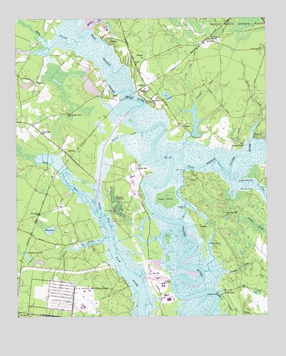
Kittredge, SC USGS Topographic Map
Click on map above to begin viewing in our Map Viewer.

This topographic map contains these locations and features:
Feature Name Type Latitude Longitude GNIS ID View Map
Big Dam LeadStreamN33.0899°W79.9109°1229418View Map
Bluff PlantationLocaleN33.0927°W79.9498°1234438View Map
Bonneau FerryLocaleN33.0724°W79.8831°1229444View Map
Bonneau Ferry Plantation CemeteryCemeteryN33.0724°W79.8881°1234441View Map
Bonnie ReserveReservoirN33.0309°W79.9034°1229445View Map
Cedar Creek LandingPopulated PlaceN33.0529°W79.8817°1231145View Map
Cherry Hill PlantationLocaleN33.0410°W79.8754°1234462View Map
Chicken CreekStreamN33.0391°W79.9545°1229550View Map
ChildsburyPopulated PlaceN33.0971°W79.9340°1247284View Map
Coingtee LakeLakeN33.0818°W79.9104°1228023View Map
ComingteePopulated PlaceN33.0796°W79.9170°1247354View Map
Comingtee CreekStreamN33.0696°W79.9176°1229582View Map
Cordesville Rural Fire Department Station 2BuildingN33.1198°W79.9005°2368468View Map
Cote BasLocaleN33.0177°W79.9320°1247399View Map
Cote Bas LandingPopulated PlaceN33.0149°W79.9240°1231197View Map
Crane PondReservoirN33.0364°W79.9835°1229604View Map
Cypress GardensParkN33.0477°W79.9490°1229616View Map
Cypress Gardens CemeteryCemeteryN33.0468°W79.9470°1234475View Map
Dean HallLocaleN33.0621°W79.9401°1247509View Map
Durham CreekStreamN33.0774°W79.9379°1229669View Map
East Branch Cooper RiverStreamN33.0668°W79.9231°1229671View Map
EllwoodPopulated PlaceN33.1110°W79.9362°1231264View Map
French Quarter CreekStreamN33.0613°W79.8934°1247832View Map
Freshing LeadStreamN33.0185°W79.9065°1229720View Map
HaganPopulated PlaceN33.0574°W79.9090°1231354View Map
Hagan IslandIslandN33.0491°W79.9251°1229763View Map
Hagan LandingPopulated PlaceN33.0610°W79.9159°1231355View Map
Kecklico Plantation (historical)LocaleN33.0793°W79.9920°1234534View Map
KittredgePopulated PlaceN33.0696°W79.9762°1231454View Map
Lake Legendre Dam D-3478DamN33.0227°W79.9863°1239940View Map
Legendre Headquarters Pond Dam D-3476DamN33.0301°W79.9669°1239938View Map
Long Field PondReservoirN33.0254°W79.9946°1229954View Map
Mayrant LeadStreamN33.0746°W79.8815°1229979View Map
Medway PlantationLocaleN33.0321°W79.9693°1234550View Map
Medway Plantation CemeteryCemeteryN33.0324°W79.9695°1234551View Map
MepkinPopulated PlaceN33.1149°W79.9523°1246623View Map
Mepkin CreekStreamN33.1210°W79.9629°1246624View Map
Molly BranchStreamN33.1174°W79.9662°1246706View Map
MorelandPopulated PlaceN33.0093°W79.8951°1230037View Map
Moreland LandingPopulated PlaceN33.0096°W79.8998°1231560View Map
Nonneau Ferry PlantationLocaleN33.0724°W79.8873°1234440View Map
Our Lady of Mepkin MonasteryChurchN33.1107°W79.9429°1252158View Map
Parnassus Plantation (historical)LocaleN33.0363°W79.9709°1234584View Map
Parnassus Plantation CemeteryCemeteryN33.0363°W79.9715°1234585View Map
Payne Chapel (historical)ChurchN33.1193°W79.9187°1234587View Map
PimlicoPopulated PlaceN33.0974°W79.9604°1230571View Map
Pimlico Fire DepartmentBuildingN33.0907°W79.9646°2368179View Map
Pimlico Plantation (historical)LocaleN33.0932°W79.9598°1234590View Map
Pine GrovePopulated PlaceN33.0435°W79.9884°1230165View Map
Plexico Plantation (historical)LocaleN33.0991°W79.9554°1706238View Map
Prioleau CreekStreamN33.0329°W79.9537°1250249View Map
Promised Land ChurchChurchN33.0852°W79.9731°1230200View Map
Promised Land SchoolSchoolN33.0774°W79.9876°1230201View Map
Reeves Telecom Pond Number One Dam D-3479DamN33.0918°W79.9581°1239941View Map
Rice HopePopulated PlaceN33.0904°W79.9329°1250360View Map
Rice Hope LakeReservoirN33.0818°W79.9104°1238713View Map
RichmondPopulated PlaceN33.0754°W79.8787°1231727View Map
Saint James ChurchChurchN33.1163°W79.9006°1230267View Map
Saw MillPopulated PlaceN33.1163°W79.9029°1234620View Map
Sawmill School (historical)SchoolN33.1157°W79.9023°1250803View Map
South Carolina Noname 08013 D-3470 DamDamN33.0361°W79.9812°1238704View Map
South Carolina Noname 08015 DamDamN33.0235°W79.9915°1238706View Map
South Carolina Noname 08024 D-3471 DamDamN33.0752°W79.9098°1238712View Map
Stokes (historical)Populated PlaceN33.0182°W79.9984°1234634View Map
Strawberry ChapelChurchN33.0935°W79.9351°1251061View Map
Strawberry Chapel CemeteryCemeteryN33.0938°W79.9351°1234638View Map
Strawberry LandingPopulated PlaceN33.0921°W79.9442°1230376View Map
Tabo ChurchChurchN33.1060°W79.9395°1251108View Map
Tarry TownPopulated PlaceN33.0813°W79.9929°1234642View Map
The TeeLocaleN33.0666°W79.9229°1230404View Map
Tin Top CampLocaleN33.0427°W79.8948°1230412View Map
Trappist MonastaryChurchN33.1210°W79.9548°1230570View Map
WappoolaPopulated PlaceN33.0979°W79.9901°1251320View Map
West Branch Cooper RiverStreamN33.0666°W79.9231°1230477View Map
WoodlandPopulated PlaceN33.0379°W79.9065°1231937View Map
Woodland LandingPopulated PlaceN33.0457°W79.9156°1230518View Map
WUJM-FM (Goose Creek)TowerN33.0018°W79.9306°1252491View Map

Note: Coordinates in the location and feature list above are referenced to NAD83 datum.


Copyright (C) 2008-2025 Ryan Niemi / Sunset Dynamics ... All Rights Reserved