TopoQuest Logo
Do you find TopoQuest useful?
Help keep TopoQuest running and adding new maps/features by donating!
Bitcoin:  19c7KJd3qBynnjoSw5npx9KScwjBe4ifkT
Litecoin:  LXs6TkuXGGXo1vDsWCkWVdjQX94eUKd6ui
Home View Maps Find Maps Find Places Resources & Links


Huger, South Carolina Topographic Map

USGS Map Title: Huger, SC
USGS Map MRC: 33079A7
DRG (GeoTIFF) Download: o33079a7.tif


Neighboring USGS Topographic Map Quads:


  Cordesville, SC  
33079B8
 

  Bethera, SC  
33079B7
 

  Shulerville, SC  
33079B6
 

  Kittredge, SC  
33079A8
 

  Huger, SC  
33079A7
 

  Ocean Bay, SC  
33079A6
 

  North Charleston, SC  
32079H8
 

  Cainhoy, SC  
32079H7
 

  Sewee Bay, SC  
32079H6


Map MRC Location:

N34°
W80°
N34°
W79°
H8 H7 H6 H5 H4 H3 H2 H1
G8 G7 G6 G5 G4 G3 G2 G1
F8 F7 F6 F5 F4 F3 F2 F1
E8 E7 E6 E5 E4 E3 E2 E1
D8 D7 D6 D5 D4 D3 D2 D1
C8 C7 C6 C5 C4 C3 C2 C1
B8 B7 B6 B5 B4 B3 B2 B1
A8 A7 A6 A5 A4 A3 A2 A1
N33°
W80°
N33°
W79°

Huger, SC USGS 1:24K Topographic Map Preview:
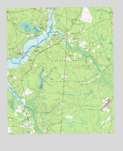
Huger, SC USGS Topographic Map
Click on map above to begin viewing in our Map Viewer.

This topographic map contains these locations and features:
Feature Name Type Latitude Longitude GNIS ID View Map
Bates PondReservoirN33.0299°W79.7577°1238703View Map
Bates StoreLocaleN33.0291°W79.7604°1229379View Map
Berefords BountyLocaleN33.0877°W79.7854°1234418View Map
Blessing PlantationLocaleN33.0577°W79.8731°1246918View Map
Bonneau Plantation (historical)LocaleN33.1204°W79.8734°1234442View Map
Bossis PlantationLocaleN33.1043°W79.8342°1229448View Map
Brickyard SchoolSchoolN33.0935°W79.7967°1229454View Map
Cainhoy Elementary / Middle SchoolSchoolN33.0210°W79.8526°1234447View Map
Cainhoy Fire Department Station 1BuildingN33.0007°W79.8492°2368406View Map
Cainhoy High SchoolSchoolN33.0207°W79.8526°1234448View Map
Cainhoy Rural Volunteer Fire Department Station 4BuildingN33.0022°W79.7557°2368332View Map
CharityPopulated PlaceN33.0060°W79.8498°1229544View Map
Charity Church (historical)ChurchN33.0016°W79.8495°1234460View Map
Charity SchoolSchoolN33.0018°W79.8495°1229546View Map
Chipper SwampSwampN33.0294°W79.8706°1229554View Map
Collins CemeteryCemeteryN33.0238°W79.7856°1229579View Map
Cypress Pond ChurchChurchN33.0791°W79.7659°1247476View Map
Deep BranchStreamN33.0735°W79.7740°1229339View Map
Dog SwampSwampN33.0746°W79.7533°1229643View Map
Eccles CemeteryCemeteryN33.1202°W79.7520°1234481View Map
Eccles ChurchChurchN33.1202°W79.7501°1247632View Map
Fowler CemeteryCemeteryN33.0249°W79.7556°1229715View Map
Francis Marion Seed Shelter OrchardLocaleN33.1199°W79.7815°1230573View Map
Gobel SwampSwampN33.0186°W79.8430°1229737View Map
Gough CreekStreamN33.1227°W79.8192°1229741View Map
Green BayPopulated PlaceN33.0149°W79.7554°1231341View Map
Hard Pinch ReserveReservoirN33.0556°W79.8350°1229773View Map
Hester CanalCanalN33.0838°W79.7973°1229792View Map
Hollion Hill PlantationLocaleN33.0735°W79.8498°1246014View Map
Hopewell ChurchChurchN33.0810°W79.7698°1234526View Map
HugerPopulated PlaceN33.0966°W79.8034°1246094View Map
Huger Census Designated PlaceCensusN33.0341°W79.8073°2629832View Map
Huger CreekStreamN33.1010°W79.8248°1229833View Map
Huger Fire DepartmentBuildingN33.0808°W79.8051°2368363View Map
Hyde Park Plantation (historical)LocaleN33.1196°W79.8279°1234530View Map
Hyde Park Plantation CemeteryCemeteryN33.1196°W79.8284°1234531View Map
Irvin Chapel (historical)SchoolN33.1238°W79.8431°1234533View Map
Irwin ChapelChurchN33.1238°W79.8426°1246128View Map
Leneigh ReserveReservoirN33.0477°W79.8360°1229900View Map
Limerick plantationLocaleN33.1243°W79.8426°1230576View Map
Long Pond SavannahSwampN33.0539°W79.8247°1229956View Map
Lower ReserveReservoirN33.1000°W79.8416°1229958View Map
Menzer RunStreamN33.0702°W79.7720°1229998View Map
Middleburg PlantationLocaleN33.0810°W79.8431°1246635View Map
Muddy CreekStreamN33.1216°W79.7620°1230077View Map
New HopePopulated PlaceN33.0896°W79.8165°1234565View Map
New Hope ChurchChurchN33.0891°W79.8165°1230096View Map
New Hope SchoolSchoolN33.0771°W79.8012°1230098View Map
Northampton Fire TowerTowerN33.0729°W79.7559°2368393View Map
Northampton Fire TowerTowerN33.0729°W79.7559°1249895View Map
Old JoePopulated PlaceN33.0557°W79.8079°1231614View Map
Pinckney Reserve BranchStreamN33.0513°W79.7740°1230163View Map
Pompion Hill ChapelChurchN33.0866°W79.8404°1250209View Map
Pompion Hill Chapel CemeteryCemeteryN33.0863°W79.8404°1234599View Map
Quarterman BranchStreamN33.0949°W79.8287°1230210View Map
Quimby CemeteryCemeteryN33.1018°W79.8037°1234601View Map
Quimby CreekStreamN33.1013°W79.8248°1250276View Map
Quimby Holiness ChurchChurchN33.1016°W79.8037°1234602View Map
Quinby BridgeBridgeN33.0943°W79.8081°1250277View Map
Quinby PlantationLocaleN33.0974°W79.8179°1230212View Map
Quinby SchoolSchoolN33.1021°W79.8034°1250278View Map
Red Bank ReserveReservoirN33.0603°W79.8254°1230220View Map
Red HillPopulated PlaceN33.0229°W79.8542°1234604View Map
Rice Hope PlantationLocaleN33.1188°W79.8273°1230574View Map
Richmond PlantationLocaleN33.0799°W79.8576°1230239View Map
Richmond Plantation CemeteryCemeteryN33.0793°W79.8581°1234607View Map
Saint Francis ChurchChurchN33.0832°W79.7740°1230575View Map
Saint Phillips ChurchChurchN33.0843°W79.7809°1230282View Map
Silk Hope Plantation (historical)LocaleN33.1185°W79.8179°1234626View Map
Silk Hope Plantation CemeteryCemeteryN33.1179°W79.8181°1234627View Map
Slave CemeteryCemeteryN33.0938°W79.8159°1230333View Map
SmithPopulated PlaceN33.0579°W79.7698°1231806View Map
Smith SwampSwampN33.0181°W79.8587°1230339View Map
South Carolina Noname 08001 D-3473 DamDamN33.0268°W79.7615°1238702View Map
South Carolina Noname 08025 D-3472 DamDamN33.1052°W79.8481°1238714View Map
Spring Hill (historical)Populated PlaceN33.1127°W79.7934°1234632View Map
Spring Hill PlantationLocaleN33.0299°W79.8662°1234633View Map
Stewart ChapelChurchN33.0235°W79.8551°1230368View Map
Turpentine DamDamN33.0652°W79.8184°1230432View Map
Upper ReserveReservoirN33.1065°W79.8520°1238715View Map
Washaw CreekStreamN33.0779°W79.7842°1230465View Map
WWWZ-FM (Summerville)TowerN33.0588°W79.8540°1252549View Map
York Bottom CreekStreamN33.0896°W79.8029°1230525View Map
Zion ChurchChurchN33.0532°W79.8576°1230528View Map

Note: Coordinates in the location and feature list above are referenced to NAD83 datum.


Copyright (C) 2008-2025 Ryan Niemi / Sunset Dynamics ... All Rights Reserved