TopoQuest Logo
Do you find TopoQuest useful?
Help keep TopoQuest running and adding new maps/features by donating!
Bitcoin:  19c7KJd3qBynnjoSw5npx9KScwjBe4ifkT
Litecoin:  LXs6TkuXGGXo1vDsWCkWVdjQX94eUKd6ui
Home View Maps Find Maps Find Places Resources & Links


Cannelton, Indiana Topographic Map

USGS Map Title: Cannelton, IN
USGS Map MRC: 37086H6
DRG (GeoTIFF) Download: o37086h6.tif


Neighboring USGS Topographic Map Quads:


  Fulda, IN  
38086A7
 

  Gatchel, IN  
38086A6
 

  Derby, IN  
38086A5
 

  Tell City, IN  
37086H7
 

  Cannelton, IN  
37086H6
 

  Rome, IN  
37086H5
 

  Pellville, KY  
37086G7
 

  Cloverport, KY  
37086G6
 

  Mattingly, KY  
37086G5


Map MRC Location:

N38°
W87°
N38°
W86°
H8 H7 H6 H5 H4 H3 H2 H1
G8 G7 G6 G5 G4 G3 G2 G1
F8 F7 F6 F5 F4 F3 F2 F1
E8 E7 E6 E5 E4 E3 E2 E1
D8 D7 D6 D5 D4 D3 D2 D1
C8 C7 C6 C5 C4 C3 C2 C1
B8 B7 B6 B5 B4 B3 B2 B1
A8 A7 A6 A5 A4 A3 A2 A1
N37°
W87°
N37°
W86°

Cannelton, IN USGS 1:24K Topographic Map Preview:
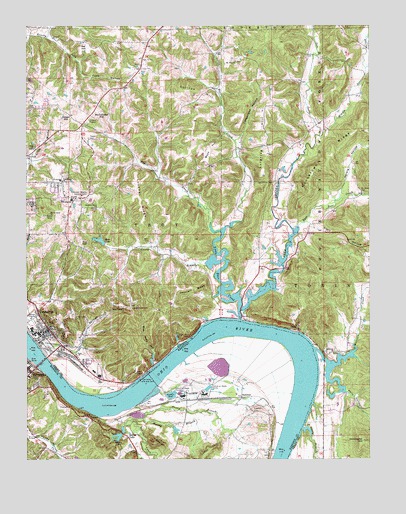
Cannelton, IN USGS Topographic Map
Click on map above to begin viewing in our Map Viewer.

This topographic map contains these locations and features:
Feature Name Type Latitude Longitude GNIS ID View Map
Blue Wells HollowValleyN37.9026°W86.7037°450689View Map
Bolin CemeteryCemeteryN37.9384°W86.7053°450692View Map
Boyd HillSummitN37.9628°W86.6836°450700View Map
Brushy HollowValleyN37.9986°W86.7423°450724View Map
Camp KochParkN37.9103°W86.6944°450750View Map
Caney BranchStreamN37.9320°W86.6883°450756View Map
CanneltonPopulated PlaceN37.9114°W86.7444°450757View Map
Cannelton City Police DepartmentBuildingN37.9125°W86.7405°2758247View Map
Cannelton Locks and DamDamN37.8979°W86.7039°450758View Map
Cannelton Volunteer Fire DepartmentBuildingN37.9121°W86.7415°2626390View Map
Chestnut Grove ChurchChurchN37.9473°W86.7244°450771View Map
Chilton HillSummitN37.9812°W86.6878°450772View Map
City of CanneltonCivilN37.9104°W86.7371°2393730View Map
Cliff CemeteryCemeteryN37.9125°W86.7364°450783View Map
Coontail RidgeRidgeN37.9248°W86.6897°450801View Map
Cox HillSummitN37.9381°W86.7297°450810View Map
Deer CreekStreamN37.9156°W86.6722°450838View Map
DoddPopulated PlaceN37.9123°W86.6519°452037View Map
Drinkwater HillSummitN37.8803°W86.6272°450864View Map
East Deer CreekStreamN37.9434°W86.6492°450877View Map
Echo Valley LakeReservoirN37.9381°W86.7230°450881View Map
Echo Valley Lake DamDamN37.9384°W86.7217°451754View Map
Fairview CemeteryCemeteryN37.8887°W86.6669°491903View Map
Funk HollowValleyN37.9856°W86.7292°450946View Map
Goosetown RidgeRidgeN37.9587°W86.6422°450970View Map
Gospel TabernacleChurchN37.9187°W86.7117°450973View Map
Hancock County Emergency Ambulance ServiceBuildingN37.8945°W86.7467°2719162View Map
Hancock County Sheriff's OfficeBuildingN37.9013°W86.7498°2767543View Map
Hawesville DivisionCivilN37.8780°W86.7390°1937050View Map
Helwig HollowValleyN37.9528°W86.6324°451027View Map
Helwig Hollow PondReservoirN37.9576°W86.6300°452510View Map
Hoosier Heights Country ClubLocaleN37.9512°W86.7297°452338View Map
Ikel HillSummitN37.9939°W86.7275°451081View Map
Indian CreekStreamN37.8901°W86.7111°494932View Map
Indian LakeLocaleN37.8817°W86.7133°494975View Map
Indian LakeReservoirN37.8806°W86.7170°494976View Map
Jeffry CliffCliffN37.8781°W86.6830°495198View Map
Keiser HillSummitN37.9731°W86.7353°451112View Map
Kelly HollowValleyN37.8948°W86.6344°451113View Map
Klein HollowValleyN37.9419°W86.6462°451119View Map
Lincoln Toll Road BridgeBridgeN37.9031°W86.7447°451148View Map
Lincoln Trail BridgeBridgeN37.9028°W86.7447°496562View Map
Little Deer CreekStreamN37.9176°W86.6725°451155View Map
Lockner RidgeRidgeN37.9501°W86.7086°451167View Map
Log Church CemeteryCemeteryN37.9551°W86.6600°451168View Map
Lost Lake PondLakeN37.9883°W86.6529°451717View Map
Lutgring HillSummitN37.9637°W86.6622°451187View Map
McCallister HillSummitN37.9731°W86.7230°451206View Map
Middle Deer CreekStreamN37.9684°W86.6430°451212View Map
Miller BranchStreamN37.9881°W86.6255°451219View Map
Millstone ChurchChurchN37.9056°W86.6383°451225View Map
Millstone CreekStreamN37.9064°W86.6447°451226View Map
Mount Zion ChurchChurchN37.9898°W86.6739°451257View Map
Muddy BranchStreamN37.8867°W86.7075°499029View Map
Murmer CreekStreamN37.9881°W86.6258°451267View Map
Neglie CreekStreamN37.9434°W86.6828°451270View Map
Perry County Memorial HospitalHospitalN37.9680°W86.7317°2660486View Map
Perry County Sheriff's OfficeBuildingN37.9123°W86.7409°2758454View Map
Powell CemeteryCemeteryN37.9675°W86.7272°451365View Map
Rock Island Post Office (historical)Post OfficeN37.9151°W86.6864°452984View Map
Saint Johns CemeteryCemeteryN37.9520°W86.6283°452515View Map
Saint Michaels CemeteryCemeteryN37.9164°W86.7333°451421View Map
Sandy BranchStreamN37.8881°W86.7069°502974View Map
Sandy BranchStreamN37.8837°W86.6494°451433View Map
Shafer HillSummitN37.8781°W86.6972°503226View Map
SkillmanPopulated PlaceN37.8928°W86.6717°509071View Map
Sterretts BottomFlatN37.8948°W86.6563°2743752View Map
Sulphur Springs HollowValleyN37.9075°W86.7310°451529View Map
Tell City Junior High SchoolSchoolN37.9501°W86.7333°451730View Map
Tell Street ChurchChurchN37.9553°W86.7367°451549View Map
Timberlake HollowValleyN37.9673°W86.6725°451567View Map
Timberlake PondReservoirN37.9924°W86.6678°451718View Map
Township of TroyCivilN37.9576°W86.7178°453903View Map

Note: Coordinates in the location and feature list above are referenced to NAD83 datum.


Copyright (C) 2008-2024 Ryan Niemi / Sunset Dynamics ... All Rights Reserved