TopoQuest Logo
Do you find TopoQuest useful?
Help keep TopoQuest running and adding new maps/features by donating!
Bitcoin:  19c7KJd3qBynnjoSw5npx9KScwjBe4ifkT
Litecoin:  LXs6TkuXGGXo1vDsWCkWVdjQX94eUKd6ui
Home View Maps Find Maps Find Places Resources & Links


Tell City, Indiana Topographic Map

USGS Map Title: Tell City, IN
USGS Map MRC: 37086H7
DRG (GeoTIFF) Download: o37086h7.tif


Neighboring USGS Topographic Map Quads:


  Santa Claus, IN  
38086A8
 

  Fulda, IN  
38086A7
 

  Gatchel, IN  
38086A6
 

  Lewisport, KY  
37086H8
 

  Tell City, IN  
37086H7
 

  Cannelton, IN  
37086H6
 

  Maceo, KY  
37086G8
 

  Pellville, KY  
37086G7
 

  Cloverport, KY  
37086G6


Map MRC Location:

N38°
W87°
N38°
W86°
H8 H7 H6 H5 H4 H3 H2 H1
G8 G7 G6 G5 G4 G3 G2 G1
F8 F7 F6 F5 F4 F3 F2 F1
E8 E7 E6 E5 E4 E3 E2 E1
D8 D7 D6 D5 D4 D3 D2 D1
C8 C7 C6 C5 C4 C3 C2 C1
B8 B7 B6 B5 B4 B3 B2 B1
A8 A7 A6 A5 A4 A3 A2 A1
N37°
W87°
N37°
W86°

Tell City, IN USGS 1:24K Topographic Map Preview:
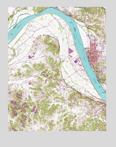
Tell City, IN USGS Topographic Map
Click on map above to begin viewing in our Map Viewer.

This topographic map contains these locations and features:
Feature Name Type Latitude Longitude GNIS ID View Map
AdairPopulated PlaceN37.9506°W86.8267°507373View Map
Anderson RiverStreamN37.9987°W86.8094°450631View Map
City of HawesvilleCivilN37.8962°W86.7561°2404664View Map
City of Tell CityCivilN37.9529°W86.7597°2396037View Map
Crooked CreekStreamN37.9914°W86.8400°433160View Map
Fenn HavenPopulated PlaceN37.9314°W86.7567°434445View Map
Fenn Haven LakeReservoirN37.9250°W86.7526°434446View Map
Franklin SchoolSchoolN37.9489°W86.7664°434777View Map
Greathouse CemeteryCemeteryN37.9578°W86.8400°493247View Map
Greenwood CemeteryCemeteryN37.9645°W86.7505°450983View Map
Hancock Airfield (historical)AirportN37.9428°W86.7914°517395View Map
Hancock County Airport-Ron Lewis FieldAirportN37.9541°W86.8563°2444094View Map
Happy HollowValleyN37.8887°W86.7647°493706View Map
HawesvillePopulated PlaceN37.9001°W86.7550°493884View Map
Hawesville City Police DepartmentBuildingN37.9031°W86.7522°2767497View Map
Hawesville Volunteer Fire DepartmentBuildingN37.9030°W86.7520°2636502View Map
Henderson CemeteryCemeteryN37.9537°W86.8439°494035View Map
Hilldale United Methodist ChurchChurchN37.9096°W86.8269°494265View Map
Lamar Field Airport (historical)AirportN37.8961°W86.7897°2444099View Map
Lead CreekStreamN37.9067°W86.7533°496111View Map
Legion FieldParkN37.9531°W86.7592°437753View Map
Lewisport DivisionCivilN37.9202°W86.8657°1937103View Map
Little Windy CreekStreamN37.9570°W86.7561°451165View Map
Muddy GutGutN37.9939°W86.8197°499044View Map
Muddy GutStreamN37.9209°W86.7817°499045View Map
New ChapelChurchN37.9620°W86.8372°499300View Map
Newman Elementary SchoolSchoolN37.9531°W86.7664°440147View Map
North Yellow Creek ForkStreamN37.9220°W86.8580°499595View Map
PetriPopulated PlaceN37.9264°W86.8042°508810View Map
Poplar Grove ChurchChurchN37.9109°W86.8636°501115View Map
Saint Columbia CemeteryCemeteryN37.9317°W86.8619°502606View Map
Saint Marys ChapelChurchN37.9664°W86.7669°442700View Map
Saint Paul Elementary SchoolSchoolN37.9531°W86.7683°442788View Map
Saint Pius CemeteryCemeteryN37.9920°W86.7867°442827View Map
South Yellow Creek ForkStreamN37.9220°W86.8580°503989View Map
Tell CityPopulated PlaceN37.9514°W86.7678°451548View Map
Tell City Fire DepartmentBuildingN37.9474°W86.7692°2625996View Map
Tell City High SchoolSchoolN37.9542°W86.7639°447182View Map
Tell City Police DepartmentBuildingN37.9505°W86.7708°2758416View Map
Tell City Volunteer Fire DepartmentBuildingN37.9510°W86.7642°2626561View Map
Thrashers CemeteryCemeteryN37.9653°W86.8408°505231View Map
Town of TroyCivilN37.9960°W86.8006°2397701View Map
TroyPopulated PlaceN37.9953°W86.7978°444924View Map
Troy BendBendN37.9881°W86.8342°2743754View Map
Troy Fire DepartmentBuildingN37.9960°W86.8028°2625813View Map
Waltz CemeteryCemeteryN37.8998°W86.7758°506208View Map
Windy CreekStreamN37.9842°W86.7864°451639View Map
WKCM-AM (Hawesville)TowerN37.9056°W86.7583°517827View Map
WTCJ-AM (Tell City)TowerN37.9378°W86.7578°448480View Map

Note: Coordinates in the location and feature list above are referenced to NAD83 datum.


Copyright (C) 2008-2024 Ryan Niemi / Sunset Dynamics ... All Rights Reserved