TopoQuest Logo
Do you find TopoQuest useful?
Help keep TopoQuest running and adding new maps/features by donating!
Bitcoin:  19c7KJd3qBynnjoSw5npx9KScwjBe4ifkT
Litecoin:  LXs6TkuXGGXo1vDsWCkWVdjQX94eUKd6ui
Home View Maps Find Maps Find Places Resources & Links


Lamar, South Carolina Topographic Map

USGS Map Title: Lamar, SC
USGS Map MRC: 34080B1
DRG (GeoTIFF) Download: o34080b1.tif


Neighboring USGS Topographic Map Quads:


  Kellytown, SC  
34080C2
 

  Hartsville South, SC  
34080C1
 

  Darlington West, SC  
34079C8
 

  Bishopville East, SC  
34080B2
 

  Lamar, SC  
34080B1
 

  Timmonsville, SC  
34079B8
 

  Elliott, SC  
34080A2
 

  Lynchburg, SC  
34080A1
 

  Sardis, SC  
34079A8


Map MRC Location:

N35°
W81°
N35°
W80°
H8 H7 H6 H5 H4 H3 H2 H1
G8 G7 G6 G5 G4 G3 G2 G1
F8 F7 F6 F5 F4 F3 F2 F1
E8 E7 E6 E5 E4 E3 E2 E1
D8 D7 D6 D5 D4 D3 D2 D1
C8 C7 C6 C5 C4 C3 C2 C1
B8 B7 B6 B5 B4 B3 B2 B1
A8 A7 A6 A5 A4 A3 A2 A1
N34°
W81°
N34°
W80°

Lamar, SC USGS 1:24K Topographic Map Preview:
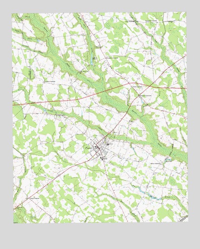
Lamar, SC USGS Topographic Map
Click on map above to begin viewing in our Map Viewer.

This topographic map contains these locations and features:
Feature Name Type Latitude Longitude GNIS ID View Map
A L Howell Dam D-3525DamN34.2335°W80.1065°1240068View Map
Andrews Mill (historical)LocaleN34.2193°W80.0665°1240793View Map
Andrews MillpondReservoirN34.2222°W80.0678°1244887View Map
Asbury Church (historical)ChurchN34.1265°W80.0831°1240797View Map
Asbury School (historical)SchoolN34.1268°W80.0831°1240798View Map
Bay LakeReservoirN34.1398°W80.0239°1220373View Map
Boggy Gully SwampStreamN34.2046°W80.0603°1220865View Map
Boyds PondReservoirN34.1626°W80.0142°1220918View Map
Carters CrossroadsPopulated PlaceN34.1402°W80.1137°1247178View Map
Elim ChurchChurchN34.2299°W80.0617°1247652View Map
Galilee School (historical)SchoolN34.2232°W80.0023°1240872View Map
Harris BranchStreamN34.2352°W80.0990°1223055View Map
Interchange 131CrossingN34.2057°W80.0262°1228168View Map
Joe Jeffords Pond Dam D-3526DamN34.1918°W80.1015°1240067View Map
Lake Swamp DivisionCivilN34.2182°W80.0084°1938321View Map
LamarPopulated PlaceN34.1688°W80.0626°1246283View Map
Lamar AcademySchoolN34.1852°W80.0412°1223795View Map
Lamar AirportAirportN34.1650°W80.0724°1251921View Map
Lamar DivisionCivilN34.1534°W80.0732°1938323View Map
Lamar Elementary SchoolSchoolN34.1715°W80.0570°1240908View Map
Lamar High SchoolSchoolN34.1718°W80.0562°1240909View Map
Lamar Police DepartmentBuildingN34.1694°W80.0638°2734275View Map
Long BranchStreamN34.2465°W80.1084°1224145View Map
McCalls BranchStreamN34.1877°W80.0334°1224385View Map
McLaughlin CrossroadsPopulated PlaceN34.2232°W80.0581°1246603View Map
Mount Tabor School (historical)SchoolN34.1402°W80.0323°1240930View Map
New Savannah Grove ChurchChurchN34.2152°W80.0759°1249854View Map
Newman SwampStreamN34.1704°W80.0209°1249868View Map
Newman Swamp ChurchChurchN34.1890°W80.0923°1249869View Map
Newman Swamp School (historical)SchoolN34.1890°W80.0915°1240938View Map
Newman Swamp Southern Methodist ChurchChurchN34.1890°W80.0931°1240939View Map
Oats ChurchChurchN34.2449°W80.0728°1249936View Map
Parnell CemeteryCemeteryN34.1982°W80.1245°1225307View Map
Philadelphia ChurchChurchN34.2446°W80.0090°1250071View Map
Philadelphia School (historical)SchoolN34.2227°W80.0303°1240953View Map
Quietude School (historical)SchoolN34.1357°W80.0348°1240963View Map
Saint Marks ChurchChurchN34.1538°W80.0242°1250598View Map
Saint Marks School (historical)SchoolN34.1546°W80.0242°1240978View Map
Scarborough CemeteryCemeteryN34.1335°W80.1206°1226437View Map
Screeches BranchStreamN34.2268°W80.0959°1226467View Map
Sity Oxidization Pond D-3527 DamDamN34.1785°W80.0498°1240066View Map
South Carolina Noname 16019 D-3528 DamDamN34.1385°W80.0198°1238464View Map
Spaulding Elementary SchoolSchoolN34.1638°W80.0620°1240994View Map
Spaulding High SchoolSchoolN34.1629°W80.0609°1250983View Map
Suggs CrossroadsPopulated PlaceN34.2452°W80.0370°1227987View Map
Town of LamarCivilN34.1695°W80.0650°2405981View Map
Town of Lamar Fire DepartmentBuildingN34.1693°W80.0639°2578414View Map
Vaughans CrossroadsPopulated PlaceN34.2088°W80.1023°1251293View Map
Whites CrossroadsPopulated PlaceN34.1602°W80.0190°1251434View Map
Wilkes CrossroadsPopulated PlaceN34.2060°W80.0390°1228001View Map
Windhams CrossroadsPopulated PlaceN34.2007°W80.0337°1228004View Map
Windlamtown School (historical)SchoolN34.1952°W80.0965°1241027View Map
Yarborough CrossroadsPopulated PlaceN34.2443°W80.0212°1251522View Map
Zion ChurchChurchN34.1788°W80.0526°1251553View Map

Note: Coordinates in the location and feature list above are referenced to NAD83 datum.


Copyright (C) 2008-2025 Ryan Niemi / Sunset Dynamics ... All Rights Reserved