TopoQuest Logo
Do you find TopoQuest useful?
Help keep TopoQuest running and adding new maps/features by donating!
Bitcoin:  19c7KJd3qBynnjoSw5npx9KScwjBe4ifkT
Litecoin:  LXs6TkuXGGXo1vDsWCkWVdjQX94eUKd6ui
Home View Maps Find Maps Find Places Resources & Links


Elliott, South Carolina Topographic Map

USGS Map Title: Elliott, SC
USGS Map MRC: 34080A2
DRG (GeoTIFF) Download: o34080a2.tif


Neighboring USGS Topographic Map Quads:


  Bishopville West, SC  
34080B3
 

  Bishopville East, SC  
34080B2
 

  Lamar, SC  
34080B1
 

  Oswego, SC  
34080A3
 

  Elliott, SC  
34080A2
 

  Lynchburg, SC  
34080A1
 

  Sumter East, SC  
33080H3
 

  Mayesville, SC  
33080H2
 

  Turbeville, SC  
33080H1


Map MRC Location:

N35°
W81°
N35°
W80°
H8 H7 H6 H5 H4 H3 H2 H1
G8 G7 G6 G5 G4 G3 G2 G1
F8 F7 F6 F5 F4 F3 F2 F1
E8 E7 E6 E5 E4 E3 E2 E1
D8 D7 D6 D5 D4 D3 D2 D1
C8 C7 C6 C5 C4 C3 C2 C1
B8 B7 B6 B5 B4 B3 B2 B1
A8 A7 A6 A5 A4 A3 A2 A1
N34°
W81°
N34°
W80°

Elliott, SC USGS 1:24K Topographic Map Preview:
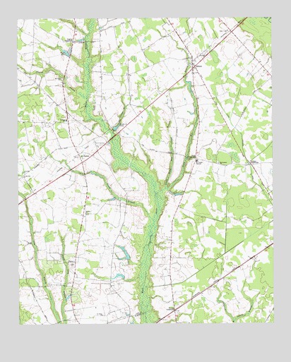
Elliott, SC USGS Topographic Map
Click on map above to begin viewing in our Map Viewer.

This topographic map contains these locations and features:
Feature Name Type Latitude Longitude GNIS ID View Map
Atkins Drainage CanalCanalN34.0713°W80.1392°1220264View Map
Barber Mill ChurchChurchN34.0185°W80.1492°1236890View Map
Barber Mill School (historical)SchoolN34.0182°W80.1498°1236891View Map
Casual BranchStreamN34.0785°W80.2040°1221389View Map
Center Point School (historical)SchoolN34.0246°W80.1756°1236904View Map
Curry Institute (historical)SchoolN34.0446°W80.2165°1236908View Map
Dunlape CrossroadsPopulated PlaceN34.0652°W80.1351°1231248View Map
ElliottPopulated PlaceN34.1071°W80.1637°1247658View Map
Elliott Baptist ChurchChurchN34.1088°W80.1656°1236913View Map
Elliott School (historical)SchoolN34.0971°W80.1731°1236914View Map
English CrossroadsPopulated PlaceN34.1157°W80.2223°1247672View Map
Lawry BranchStreamN34.0015°W80.1445°1223842View Map
Lee County Rural Fire Department Black RiverBuildingN34.0775°W80.2011°2578319View Map
Little Stony Run BranchStreamN34.0560°W80.1776°1246435View Map
Mattie Js PondReservoirN34.0806°W80.2016°1224369View Map
Mattie Js Pond Dam D-2422DamN34.0799°W80.2026°1239481View Map
McDonald School (historical)SchoolN34.0910°W80.1356°1236933View Map
Meadow BranchStreamN34.0927°W80.2156°1221591View Map
Minnie Deschamps PondReservoirN34.0198°W80.2006°1238246View Map
Mount Pleasant ChurchChurchN34.0657°W80.1515°1249657View Map
Mount Pleasant High SchoolSchoolN34.0668°W80.1620°1224788View Map
Mount Pleasant School (historical)SchoolN34.0657°W80.1517°1236939View Map
Mount Zion ChurchChurchN34.1007°W80.2284°1224828View Map
Nancy BranchStreamN34.0429°W80.1834°1224918View Map
Player PondReservoirN34.1112°W80.2258°1225526View Map
Players Pond Dam D-1728DamN34.1104°W80.2242°1239483View Map
Rhodes CrossroadsPopulated PlaceN34.0057°W80.1737°1250356View Map
Riverside SchoolSchoolN34.0835°W80.2256°1250398View Map
Saint CharlesPopulated PlaceN34.0665°W80.2181°1226097View Map
Saint Charles DivisionCivilN34.0738°W80.2405°1938404View Map
Saint James ChurchChurchN34.0038°W80.2090°1226122View Map
Saint James School Number 1 (historical)SchoolN34.1035°W80.2484°1236952View Map
Saint Lukes ChurchChurchN34.1032°W80.1637°1250575View Map
Saint Marriahs ChurchChurchN34.0604°W80.2476°1250605View Map
Saint Matthews School (historical)SchoolN34.0843°W80.1929°1236956View Map
Saint Pauls ChurchChurchN34.1102°W80.1573°1250664View Map
Saint Sinai ChurchChurchN34.0454°W80.2165°1250703View Map
South Carolina Noname 31003 D-2424 DamDamN34.0268°W80.1965°1238243View Map
South Carolina Noname 31004 D-2423 DamDamN34.0202°W80.1981°1238245View Map
Stony Run BranchStreamN34.0535°W80.1815°1251057View Map
Tallon Field (historical)AirportN34.1010°W80.1256°1251933View Map
Turners PondReservoirN34.0281°W80.1967°1238244View Map
Unionville ChurchChurchN34.0621°W80.2465°1251273View Map
Wells CemeteryCemeteryN34.0671°W80.1645°1706230View Map
Wells Church (historical)ChurchN34.0674°W80.1651°1236977View Map
Wells CrossroadsPopulated PlaceN34.0679°W80.1626°1227995View Map

Note: Coordinates in the location and feature list above are referenced to NAD83 datum.


Copyright (C) 2008-2025 Ryan Niemi / Sunset Dynamics ... All Rights Reserved