TopoQuest Logo
Do you find TopoQuest useful?
Help keep TopoQuest running and adding new maps/features by donating!
Bitcoin:  19c7KJd3qBynnjoSw5npx9KScwjBe4ifkT
Litecoin:  LXs6TkuXGGXo1vDsWCkWVdjQX94eUKd6ui
Home View Maps Find Maps Find Places Resources & Links


Cannonville, Utah Topographic Map

USGS Map Title: Cannonville, UT
USGS Map MRC: 37112E1
DRG (GeoTIFF) Download: o37112e1.tif


Neighboring USGS Topographic Map Quads:


  Bryce Canyon, UT  
37112F2
 

  Tropic Canyon, UT  
37112F1
 

  Pine Lake, UT  
37111F8
 

  Bryce Point, UT  
37112E2
 

  Cannonville, UT  
37112E1
 

  Henrieville, UT  
37111E8
 

  Rainbow Point, UT  
37112D2
 

  Bull Valley Gorge, UT  
37112D1
 

  Slickrock Bench, UT  
37111D8


Map MRC Location:

N38°
W113°
N38°
W112°
H8 H7 H6 H5 H4 H3 H2 H1
G8 G7 G6 G5 G4 G3 G2 G1
F8 F7 F6 F5 F4 F3 F2 F1
E8 E7 E6 E5 E4 E3 E2 E1
D8 D7 D6 D5 D4 D3 D2 D1
C8 C7 C6 C5 C4 C3 C2 C1
B8 B7 B6 B5 B4 B3 B2 B1
A8 A7 A6 A5 A4 A3 A2 A1
N37°
W113°
N37°
W112°

Cannonville, UT USGS 1:24K Topographic Map Preview:
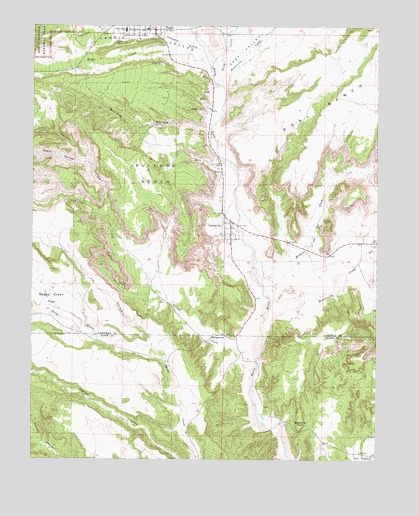
Cannonville, UT USGS Topographic Map
Click on map above to begin viewing in our Map Viewer.

This topographic map contains these locations and features:
Feature Name Type Latitude Longitude GNIS ID View Map
Bryce CreekStreamN37.6125°W112.0619°1439208View Map
Bryce Valley High SchoolSchoolN37.6247°W112.0943°1455071View Map
Bulldog BenchBenchN37.5792°W112.0769°1426143View Map
Bulldog HollowValleyN37.5951°W112.0626°1439301View Map
Campbell CreekStreamN37.6175°W112.0641°1439454View Map
CannonvillePopulated PlaceN37.5669°W112.0538°1426344View Map
Cannonville CemeteryCemeteryN37.5802°W112.0583°1435242View Map
Cannonville Post OfficePost OfficeN37.5662°W112.0551°2769082View Map
Death HollowValleyN37.5857°W112.1059°1440326View Map
Dry CreekStreamN37.5586°W112.0060°1440604View Map
East ValleyValleyN37.6083°W112.0574°1440854View Map
Garfield County AmbulanceBuildingN37.6244°W112.0874°2768452View Map
GeorgetownPopulated PlaceN37.5355°W112.0549°1437567View Map
Georgetown CemeteryCemeteryN37.5364°W112.0554°1435579View Map
Henderson CreekStreamN37.6078°W112.0557°1441700View Map
Henrieville CemeteryCemeteryN37.5653°W112.0041°1435666View Map
Henrieville CreekStreamN37.5403°W112.0424°1441710View Map
Jim HollowValleyN37.5341°W112.0824°1429164View Map
Johnson Storage DamDamN37.5564°W112.0163°1434639View Map
Johnson Storage ReservoirReservoirN37.5565°W112.0166°1434638View Map
Kodachrome Basin State ParkParkN37.5005°W112.0013°1455358View Map
LoseeLocaleN37.6239°W112.0538°1435897View Map
Merrill HollowValleyN37.5698°W112.0982°1443313View Map
North CreekStreamN37.6117°W112.0596°1443871View Map
Ott RanchLocaleN37.5617°W112.0927°1436076View Map
Paria AmphitheaterValleyN37.6055°W112.0582°1448802View Map
Promise Rock ArchArchN37.5480°W112.0321°1679093View Map
Shepherd PointSummitN37.5128°W112.0282°1432395View Map
The Church of Jesus Christ of Latter Day SaintsChurchN37.6242°W112.0844°1437113View Map
The Church of Jesus Christ of Latter Day SaintsChurchN37.5655°W112.0532°1436843View Map
Town of CannonvilleCivilN37.5821°W112.0583°2413159View Map
Town of HenrievilleCivilN37.5638°W112.0020°2412747View Map
Tropic Post OfficePost OfficeN37.6245°W112.0823°84776View Map
Tropic Volunteer Fire DepartmentBuildingN37.6244°W112.0873°2627146View Map
Wildcat WashStreamN37.5472°W112.0405°1434281View Map
Yellow CreekStreamN37.5250°W112.0466°1447552View Map

Note: Coordinates in the location and feature list above are referenced to NAD83 datum.


Copyright (C) 2008-2025 Ryan Niemi / Sunset Dynamics ... All Rights Reserved