TopoQuest Logo
Do you find TopoQuest useful?
Help keep TopoQuest running and adding new maps/features by donating!
Bitcoin:  19c7KJd3qBynnjoSw5npx9KScwjBe4ifkT
Litecoin:  LXs6TkuXGGXo1vDsWCkWVdjQX94eUKd6ui
Home View Maps Find Maps Find Places Resources & Links


Bryce Point, Utah Topographic Map

USGS Map Title: Bryce Point, UT
USGS Map MRC: 37112E2
DRG (GeoTIFF) Download: o37112e2.tif


Neighboring USGS Topographic Map Quads:


  Wilson Peak, UT  
37112F3
 

  Bryce Canyon, UT  
37112F2
 

  Tropic Canyon, UT  
37112F1
 

  Tropic Reservoir, UT  
37112E3
 

  Bryce Point, UT  
37112E2
 

  Cannonville, UT  
37112E1
 

  Podunk Creek, UT  
37112D3
 

  Rainbow Point, UT  
37112D2
 

  Bull Valley Gorge, UT  
37112D1


Map MRC Location:

N38°
W113°
N38°
W112°
H8 H7 H6 H5 H4 H3 H2 H1
G8 G7 G6 G5 G4 G3 G2 G1
F8 F7 F6 F5 F4 F3 F2 F1
E8 E7 E6 E5 E4 E3 E2 E1
D8 D7 D6 D5 D4 D3 D2 D1
C8 C7 C6 C5 C4 C3 C2 C1
B8 B7 B6 B5 B4 B3 B2 B1
A8 A7 A6 A5 A4 A3 A2 A1
N37°
W113°
N37°
W112°

Bryce Point, UT USGS 1:24K Topographic Map Preview:
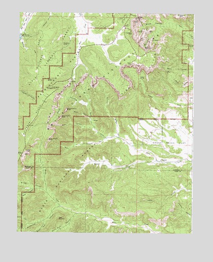
Bryce Point, UT USGS Topographic Map
Click on map above to begin viewing in our Map Viewer.

This topographic map contains these locations and features:
Feature Name Type Latitude Longitude GNIS ID View Map
Agua CanyonValleyN37.5251°W112.2381°1438137View Map
Alley Oop and DinnyPillarN37.6083°W112.1605°1448062View Map
Black Birch CanyonValleyN37.5109°W112.2076°1438825View Map
Bridge CanyonValleyN37.5245°W112.2284°1439096View Map
Bridge CreekStreamN37.5247°W112.2285°1448178View Map
Bristlecone PointSummitN37.6244°W112.1336°1439124View Map
Bryce CanyonValleyN37.6166°W112.1424°1439207View Map
Bryce Canyon National ParkParkN37.5839°W112.1827°1450197View Map
Bryce PointCapeN37.6053°W112.1574°1439209View Map
Bryce Point OverlookLocaleN37.6041°W112.1569°1448199View Map
Carmel and WisemanPillarN37.6178°W112.1655°1448220View Map
Deer MountainSummitN37.5083°W112.2205°1440388View Map
Fairview Natural BridgeArchN37.5441°W112.2452°1679064View Map
Fairy CastlePillarN37.6150°W112.1574°1440986View Map
Farview PointCliffN37.5450°W112.2469°1441016View Map
Farview Point OverlookLocaleN37.5428°W112.2480°1890890View Map
Gullivers CastlePillarN37.6228°W112.1560°1448451View Map
Hat ShopPillarN37.5922°W112.1441°1441625View Map
Henderson CreekStreamN37.6100°W112.2488°1441699View Map
Heward CreekStreamN37.5419°W112.1513°1441726View Map
Hindu TemplesCliffN37.6116°W112.1632°1448479View Map
Horse TrailTrailN37.6244°W112.1577°1448490View Map
Inspiration PointCapeN37.6133°W112.1688°1442042View Map
Inspiration Point OverlookLocaleN37.6150°W112.1705°1890886View Map
Johnson RanchLocaleN37.5417°W112.1482°1442191View Map
Joseph and MaryPillarN37.6069°W112.1527°1448525View Map
Katzenjammer KidsPillarN37.6194°W112.1644°1448541View Map
Liberty CastleCliffN37.6075°W112.1646°1448596View Map
Merrill RanchLocaleN37.5972°W112.1288°1451299View Map
Mud CanyonValleyN37.5602°W112.1957°1443657View Map
Mud Canyon ButteSummitN37.5652°W112.2198°1443658View Map
Mutt and JeffPillarN37.6194°W112.1646°1448719View Map
Navajo Loop TrailTrailN37.6178°W112.1624°1448730View Map
Noon CanyonValleyN37.5541°W112.1868°1443838View Map
Noon Canyon ButteSummitN37.5529°W112.2289°1443839View Map
North Fork Ponderosa CanyonValleyN37.5049°W112.2408°1443926View Map
North HallValleyN37.6216°W112.1557°1448748View Map
Organ Grinders MonkeyPillarN37.6214°W112.1619°1448787View Map
PagodaPillarN37.6194°W112.1646°1448792View Map
Pans PinnaclePillarN37.6194°W112.1646°1448800View Map
Paria View OverlookLocaleN37.5972°W112.1696°1444203View Map
Pasture WashStreamN37.5547°W112.1780°1444240View Map
Peekaboo CanyonValleyN37.6144°W112.1525°1448823View Map
Peekaboo Loop TrailTrailN37.6128°W112.1588°1444266View Map
Piracy PointCliffN37.5464°W112.2444°1444459View Map
Piracy Point OverlookLocaleN37.5464°W112.2446°1890889View Map
Ponderosa CanyonValleyN37.5145°W112.2196°1444571View Map
Queen VictoriaPillarN37.6241°W112.1591°1448889View Map
Queens GardenAreaN37.6250°W112.1619°1444698View Map
Queens Garden TrailTrailN37.6216°W112.1557°1448888View Map
Shaker SpringSpringN37.5867°W112.2268°1445462View Map
Sheep Creek Connecting TrailTrailN37.5791°W112.2024°1448995View Map
Sheep Creek FlatFlatN37.5505°W112.1288°1445496View Map
Short CanyonValleyN37.5655°W112.1991°1445552View Map
Silent CityPillarN37.6200°W112.1685°1445586View Map
South Fork Ponderosa CanyonValleyN37.5082°W112.2280°1445867View Map
South HallValleyN37.6178°W112.1627°1449032View Map
Sunset CampgroundLocaleN37.6222°W112.1749°1446255View Map
Sunset PointCliffN37.6222°W112.1660°1446261View Map
Sunset Point OverlookLocaleN37.6228°W112.1660°1449085View Map
Swamp CanyonValleyN37.5724°W112.2008°1446271View Map
Swamp Canyon ButteSummitN37.5699°W112.2159°1446272View Map
Swamp Canyon Connecting TrailTrailN37.5825°W112.2119°1449087View Map
Swamp Canyon OverlookLocaleN37.5875°W112.2135°1890887View Map
Temple of OsirisPillarN37.6219°W112.1630°1449097View Map
Temples of the GodsPillarN37.6194°W112.1646°1449098View Map
The AlligatorPillarN37.6097°W112.1474°1446409View Map
The CathedralSummitN37.6146°W112.1617°1446424View Map
The GossipsPillarN37.6197°W112.1619°1448436View Map
The PopePillarN37.6189°W112.1602°1448866View Map
The SentinelPillarN37.6208°W112.1649°1448988View Map
Thors HammerPillarN37.6214°W112.1638°1449100View Map
Three WisemanPillarN37.6075°W112.1527°1449102View Map
Tropic ReservoirReservoirN37.6122°W112.2494°1446724View Map
Trough SpringSpringN37.5823°W112.2271°1446734View Map
TurtlePillarN37.6197°W112.1660°1449118View Map
Two BridgesArchN37.6203°W112.1544°1449121View Map
Under-the-Rim TrailTrailN37.5658°W112.2235°1449128View Map
Wall of WindowsPillarN37.6083°W112.1646°1446966View Map
Wall StreetPillarN37.6183°W112.1644°1890843View Map
Whiteman BenchBenchN37.5833°W112.2341°1447288View Map
Whiteman Connecting TrailTrailN37.5619°W112.2349°1449190View Map
Whiteman SpringSpringN37.6069°W112.2154°1447289View Map
Yellow SpringSpringN37.5888°W112.1635°1447561View Map

Note: Coordinates in the location and feature list above are referenced to NAD83 datum.


Copyright (C) 2008-2025 Ryan Niemi / Sunset Dynamics ... All Rights Reserved