TopoQuest Logo
Do you find TopoQuest useful?
Help keep TopoQuest running and adding new maps/features by donating!
Bitcoin:  19c7KJd3qBynnjoSw5npx9KScwjBe4ifkT
Litecoin:  LXs6TkuXGGXo1vDsWCkWVdjQX94eUKd6ui
Home View Maps Find Maps Find Places Resources & Links


Millis, Wyoming Topographic Map

USGS Map Title: Millis, WY
USGS Map MRC: 41110B8
DRG (GeoTIFF) Download: o41110b8.tif


Neighboring USGS Topographic Map Quads:


  Murphy Ridge, UT  
41111C1
 

  Evanston, WY  
41110C8
 

  Guild Hollow, WY  
41110C7
 

  Wahsatch, UT  
41111B1
 

  Millis, WY  
41110B8
 

  Sulphur Creek Reservoir, WY  
41110B7
 

  Porcupine Ridge, UT  
41111A1
 

  Myers Reservoir, WY  
41110A8
 

  Pine Knoll, WY  
41110A7


Map MRC Location:

N42°
W111°
N42°
W110°
H8 H7 H6 H5 H4 H3 H2 H1
G8 G7 G6 G5 G4 G3 G2 G1
F8 F7 F6 F5 F4 F3 F2 F1
E8 E7 E6 E5 E4 E3 E2 E1
D8 D7 D6 D5 D4 D3 D2 D1
C8 C7 C6 C5 C4 C3 C2 C1
B8 B7 B6 B5 B4 B3 B2 B1
A8 A7 A6 A5 A4 A3 A2 A1
N41°
W111°
N41°
W110°

Millis, WY USGS 1:24K Topographic Map Preview:
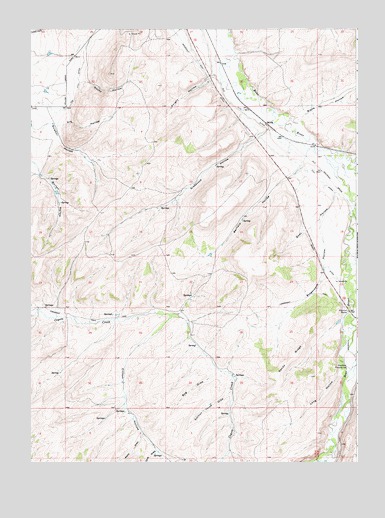
Millis, WY USGS Topographic Map
Click on map above to begin viewing in our Map Viewer.

This topographic map contains these locations and features:
Feature Name Type Latitude Longitude GNIS ID View Map
Bernard HollowValleyN41.2116°W110.8957°1585395View Map
Berry DrawValleyN41.1333°W110.9580°1585399View Map
Blake HollowValleyN41.2244°W110.8999°1585646View Map
Bog DrawValleyN41.1508°W110.9280°1585735View Map
Clifton HollowValleyN41.1672°W110.9468°1586779View Map
Cove DrawValleyN41.1288°W110.9518°1587098View Map
Dry HollowValleyN41.2222°W110.9899°1587852View Map
Duel HollowValleyN41.2019°W110.8841°1587896View Map
East DamDamN41.2183°W110.9907°1607831View Map
East ReservoirReservoirN41.2183°W110.9907°1607832View Map
Emigrant TrailTrailN41.1663°W110.9788°1588296View Map
Evanston Pumping StationLocaleN41.1527°W110.8793°1588346View Map
Evanston Regional HospitalHospitalN41.2432°W110.9906°1794883View Map
Glasscock HollowValleyN41.2211°W110.9099°1588928View Map
Jamison ClaimMineN41.1625°W110.8808°1746955View Map
Knight HollowValleyN41.2372°W110.9307°1590399View Map
Long HollowValleyN41.1508°W110.8816°1590985View Map
Meadow DrawValleyN41.1258°W110.9482°1591434View Map
Rocky HollowValleyN41.2344°W110.9816°1593605View Map
Sandy RidgeRidgeN41.1544°W110.9007°1593936View Map
Section Three DrawValleyN41.1455°W110.9241°1594084View Map
Spring CreekStreamN41.1255°W110.8913°1596933View Map
Stagecoach HollowValleyN41.1941°W110.8891°1594962View Map
Stowe CreekStreamN41.2130°W110.8771°1595100View Map
Uinta County Fire Protection Evanston Station 3BuildingN41.2444°W110.9363°2673489View Map

Note: Coordinates in the location and feature list above are referenced to NAD83 datum.


Copyright (C) 2008-2025 Ryan Niemi / Sunset Dynamics ... All Rights Reserved