TopoQuest Logo
Do you find TopoQuest useful?
Help keep TopoQuest running and adding new maps/features by donating!
Bitcoin:  19c7KJd3qBynnjoSw5npx9KScwjBe4ifkT
Litecoin:  LXs6TkuXGGXo1vDsWCkWVdjQX94eUKd6ui
Home View Maps Find Maps Find Places Resources & Links


Evanston, Wyoming Topographic Map

USGS Map Title: Evanston, WY
USGS Map MRC: 41110C8
DRG (GeoTIFF) Download: o41110c8.tif


Neighboring USGS Topographic Map Quads:


  Neponset Reservoir NE, UT  
41111D1
 

  Three Forks, WY  
41110D8
 

  Little Dee Creek, WY  
41110D7
 

  Murphy Ridge, UT  
41111C1
 

  Evanston, WY  
41110C8
 

  Guild Hollow, WY  
41110C7
 

  Wahsatch, UT  
41111B1
 

  Millis, WY  
41110B8
 

  Sulphur Creek Reservoir, WY  
41110B7


Map MRC Location:

N42°
W111°
N42°
W110°
H8 H7 H6 H5 H4 H3 H2 H1
G8 G7 G6 G5 G4 G3 G2 G1
F8 F7 F6 F5 F4 F3 F2 F1
E8 E7 E6 E5 E4 E3 E2 E1
D8 D7 D6 D5 D4 D3 D2 D1
C8 C7 C6 C5 C4 C3 C2 C1
B8 B7 B6 B5 B4 B3 B2 B1
A8 A7 A6 A5 A4 A3 A2 A1
N41°
W111°
N41°
W110°

Evanston, WY USGS 1:24K Topographic Map Preview:
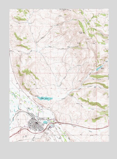
Evanston, WY USGS Topographic Map
Click on map above to begin viewing in our Map Viewer.

This topographic map contains these locations and features:
Feature Name Type Latitude Longitude GNIS ID View Map
Almy Number Five MineMineN41.3319°W110.9899°1746968View Map
Almy Number Forty-one MineMineN41.3255°W110.9996°1746967View Map
Almy Number Four MineMineN41.3274°W110.9888°1746966View Map
Almy Number One MineMineN41.3138°W110.9971°1746962View Map
Almy Number Thirty-one MineMineN41.3022°W110.9885°1746965View Map
Almy Number Three MineMineN41.2708°W110.9482°1746964View Map
Almy Number Two MineMineN41.3058°W110.9935°1746963View Map
Aspen SchoolSchoolN41.2683°W110.9632°1795650View Map
Bear River MallLocaleN41.2538°W110.9546°1764033View Map
Burnt HillSummitN41.2547°W110.9818°1586174View Map
City CemeteryCemeteryN41.2794°W110.9599°2056745View Map
City DitchCanalN41.2533°W110.9449°1586727View Map
City of EvanstonCivilN41.2603°W110.9646°2410468View Map
Clark SchoolSchoolN41.2683°W110.9632°1795651View Map
Crompton DamDamN41.2883°W110.9657°1607873View Map
Crompton ReservoirReservoirN41.2883°W110.9657°1607874View Map
Crompton ReservoirReservoirN41.2909°W110.9549°1587228View Map
Davis Middle SchoolSchoolN41.2683°W110.9632°1795648View Map
Duncomb HollowValleyN41.2663°W110.9366°1587919View Map
EvanstonPopulated PlaceN41.2683°W110.9632°1588345View Map
Evanston City CemeteryCemeteryN41.2805°W110.9600°2073275View Map
Evanston High SchoolSchoolN41.2683°W110.9632°1795647View Map
Evanston Middle SchoolSchoolN41.2683°W110.9632°1795649View Map
Evanston Police DepartmentBuildingN41.2699°W110.9669°2752648View Map
Evanston Post OfficePost OfficeN41.2691°W110.9670°2768517View Map
Foote SpringSpringN41.3019°W110.8909°1588614View Map
Front Street MallLocaleN41.2538°W110.9546°1764034View Map
Hamblin ParkFlatN41.2722°W110.9496°1589264View Map
KOTB-FM (Evanston)TowerN41.3530°W110.9085°1608918View Map
Lake LouiseLakeN41.2656°W110.9470°1591060View Map
Limekiln GulchValleyN41.2933°W110.9374°1590690View Map
Long HollowValleyN41.3099°W110.9005°1590987View Map
Medicine ButteSummitN41.3522°W110.9080°1609124View Map
North Evanston SchoolSchoolN41.2683°W110.9632°1795652View Map
Old City DitchCanalN41.2558°W110.9441°1596878View Map
Painter DamDamN41.3133°W110.8924°1607871View Map
Painter ReservoirReservoirN41.3194°W110.8872°1592552View Map
Pioneer Counseling Resource Services HospitalHospitalN41.2683°W110.9632°1794865View Map
Pleasant Valley CreekStreamN41.2911°W110.9774°1592876View Map
Red CanyonValleyN41.3383°W110.9985°1593250View Map
Robinson HollowValleyN41.3016°W110.9091°1593539View Map
Rocky Mountain Care Hospital of EvanstonHospitalN41.2683°W110.9632°1794905View Map
Spring HollowValleyN41.2947°W110.9257°1594918View Map
Uinta County Fire Protection Evanston Station 2BuildingN41.2727°W110.9574°2673488View Map
Uinta County Fire Protection Station 1BuildingN41.2697°W110.9666°2673456View Map
Uinta County SheriffBuildingN41.2693°W110.9213°2752603View Map
Uinta Meadows SchoolSchoolN41.2683°W110.9632°1795653View Map
Willow CreekStreamN41.3366°W110.9666°1596430View Map
Wyoming State HospitalHospitalN41.2639°W110.9481°1794884View Map
Wyoming State Hospital Cemetery LowerCemeteryN41.2679°W110.9503°2774418View Map
Wyoming State Hospital Cemetery UpperCemeteryN41.2676°W110.9493°2774419View Map
Yellow Creek Shopping MallLocaleN41.2611°W110.9682°1764035View Map

Note: Coordinates in the location and feature list above are referenced to NAD83 datum.


Copyright (C) 2008-2025 Ryan Niemi / Sunset Dynamics ... All Rights Reserved