TopoQuest Logo
Do you find TopoQuest useful?
Help keep TopoQuest running and adding new maps/features by donating!
Bitcoin:  19c7KJd3qBynnjoSw5npx9KScwjBe4ifkT
Litecoin:  LXs6TkuXGGXo1vDsWCkWVdjQX94eUKd6ui
Home View Maps Find Maps Find Places Resources & Links


Moritz Ridge, Arizona Topographic Map

USGS Map Title: Moritz Ridge, AZ
USGS Map MRC: 35111D8
DRG (GeoTIFF) Download: o35111d8.tif


Neighboring USGS Topographic Map Quads:


  Hobble Tank, AZ  
35112E1
 

  Ebert Mountain, AZ  
35111E8
 

  Chapel Mountain, AZ  
35111E7
 

  Squaw Mountain, AZ  
35112D1
 

  Moritz Ridge, AZ  
35111D8
 

  Kendrick Peak, AZ  
35111D7
 

  Sitgreaves Mountain, AZ  
35112C1
 

  Parks, AZ  
35111C8
 

  Wing Mountain, AZ  
35111C7


Map MRC Location:

N36°
W112°
N36°
W111°
H8 H7 H6 H5 H4 H3 H2 H1
G8 G7 G6 G5 G4 G3 G2 G1
F8 F7 F6 F5 F4 F3 F2 F1
E8 E7 E6 E5 E4 E3 E2 E1
D8 D7 D6 D5 D4 D3 D2 D1
C8 C7 C6 C5 C4 C3 C2 C1
B8 B7 B6 B5 B4 B3 B2 B1
A8 A7 A6 A5 A4 A3 A2 A1
N35°
W112°
N35°
W111°

Moritz Ridge, AZ USGS 1:24K Topographic Map Preview:
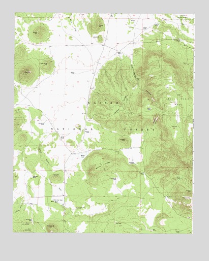
Moritz Ridge, AZ USGS Topographic Map
Click on map above to begin viewing in our Map Viewer.

This topographic map contains these locations and features:
Feature Name Type Latitude Longitude GNIS ID View Map
Backward TankReservoirN35.4370°W111.9786°25880View Map
BR TankReservoirN35.3806°W111.9288°25859View Map
Bull Basin MesaSummitN35.4497°W111.8860°26952View Map
Cable GuzzlerReservoirN35.4814°W111.9004°2088820View Map
Caporal TankReservoirN35.4942°W111.9013°27280View Map
Community TankReservoirN35.4058°W111.9284°27836View Map
Conners HumpSummitN35.4064°W111.9710°3177View Map
Drip TankReservoirN35.4919°W111.9164°2091490View Map
Dry LakeLakeN35.4361°W111.8904°28630View Map
East Elk SpringSpringN35.3766°W111.9875°28747View Map
Elk TankReservoirN35.3960°W111.8937°28868View Map
Fay LakeLakeN35.4219°W111.9719°42056View Map
Flanigan TankReservoirN35.4066°W111.9872°29056View Map
Horse TankReservoirN35.4014°W111.9563°2088819View Map
Horsethief CanyonValleyN35.4358°W111.9027°30207View Map
Juniper RidgeRidgeN35.4478°W111.9240°30669View Map
Juniper TankReservoirN35.4325°W111.9475°30686View Map
Little TankReservoirN35.4062°W111.8844°31139View Map
Lost SpringSpringN35.4714°W111.8818°37913View Map
Lost Spring TankReservoirN35.4849°W111.8840°31309View Map
Lost Spring Water TankReservoirN35.4717°W111.8802°42057View Map
Marlar TankReservoirN35.4319°W111.9049°2088811View Map
Miller Spring TankReservoirN35.3936°W111.9725°31873View Map
Miller Wash TankReservoirN35.3921°W111.9682°31883View Map
Moritz LakeLakeN35.4199°W111.9499°32034View Map
Moritz RidgeSummitN35.4128°W111.9363°32035View Map
Newman HillSummitN35.3947°W111.8760°32312View Map
Newman TankReservoirN35.3995°W111.8767°32319View Map
Perreault TankReservoirN35.4146°W111.9197°42053View Map
Potato HillSummitN35.4928°W111.9424°33131View Map
Potato TankReservoirN35.4909°W111.9108°33148View Map
Pumpkin CenterPopulated PlaceN35.4147°W111.9160°33227View Map
Pumpkin KnollSummitN35.4278°W111.9227°33228View Map
Pumpkin TankReservoirN35.4090°W111.9094°33229View Map
Rabbit LakeReservoirN35.4659°W111.9582°33305View Map
Raymond LakeLakeN35.4088°W111.9590°38028View Map
Red HillSummitN35.4656°W111.9913°33448View Map
Red TankReservoirN35.3773°W111.9033°33522View Map
Section Sixteen HillSummitN35.3772°W111.9738°34208View Map
Section Ten TankReservoirN35.3891°W111.9549°34238View Map
Serape TankReservoirN35.3762°W111.8844°34263View Map
Sheep HillSummitN35.4886°W111.9846°34335View Map
Smith TankReservoirN35.4302°W111.9664°34567View Map
Spring ValleyValleyN35.3845°W111.9632°34739View Map
Spud HillSummitN35.4864°W111.9413°34754View Map
Spud TankReservoirN35.4808°W111.9650°2091489View Map
Tiptop TankReservoirN35.4459°W111.9057°35352View Map
Turkey TankReservoirN35.4494°W111.9018°45029View Map
W-Triangle TankReservoirN35.3816°W111.9863°35796View Map
West Elk SpringSpringN35.3796°W111.9889°35975View Map
White TankReservoirN35.4775°W111.9258°36117View Map
Wild Horse CanyonValleyN35.4778°W111.9204°36164View Map
Wild Horse HillSummitN35.4711°W111.9771°36167View Map
Wildlife GuzzlerReservoirN35.4622°W111.9182°2088821View Map
Wildlife GuzzlerReservoirN35.3800°W111.9246°2088822View Map

Note: Coordinates in the location and feature list above are referenced to NAD83 datum.


Copyright (C) 2008-2024 Ryan Niemi / Sunset Dynamics ... All Rights Reserved