TopoQuest Logo
Do you find TopoQuest useful?
Help keep TopoQuest running and adding new maps/features by donating!
Bitcoin:  19c7KJd3qBynnjoSw5npx9KScwjBe4ifkT
Litecoin:  LXs6TkuXGGXo1vDsWCkWVdjQX94eUKd6ui
Home View Maps Find Maps Find Places Resources & Links


Kendrick Peak, Arizona Topographic Map

USGS Map Title: Kendrick Peak, AZ
USGS Map MRC: 35111D7
DRG (GeoTIFF) Download: o35111d7.tif


Neighboring USGS Topographic Map Quads:


  Ebert Mountain, AZ  
35111E8
 

  Chapel Mountain, AZ  
35111E7
 

  S P Mountain, AZ  
35111E6
 

  Moritz Ridge, AZ  
35111D8
 

  Kendrick Peak, AZ  
35111D7
 

  White Horse Hills, AZ  
35111D6
 

  Parks, AZ  
35111C8
 

  Wing Mountain, AZ  
35111C7
 

  Humphreys Peak, AZ  
35111C6


Map MRC Location:

N36°
W112°
N36°
W111°
H8 H7 H6 H5 H4 H3 H2 H1
G8 G7 G6 G5 G4 G3 G2 G1
F8 F7 F6 F5 F4 F3 F2 F1
E8 E7 E6 E5 E4 E3 E2 E1
D8 D7 D6 D5 D4 D3 D2 D1
C8 C7 C6 C5 C4 C3 C2 C1
B8 B7 B6 B5 B4 B3 B2 B1
A8 A7 A6 A5 A4 A3 A2 A1
N35°
W112°
N35°
W111°

Kendrick Peak, AZ USGS 1:24K Topographic Map Preview:
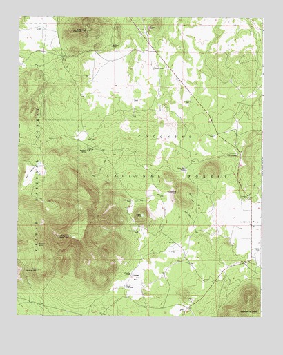
Kendrick Peak, AZ USGS Topographic Map
Click on map above to begin viewing in our Map Viewer.

This topographic map contains these locations and features:
Feature Name Type Latitude Longitude GNIS ID View Map
Antelope WellWellN35.4647°W111.7877°25693View Map
Bald Hill TankReservoirN35.3886°W111.8687°37627View Map
Bull BasinBasinN35.4345°W111.8693°26949View Map
Bull Basin TanksReservoirN35.4376°W111.8647°37683View Map
Cabin Flat HillSummitN35.4372°W111.7752°41904View Map
Cabin Flat TanksReservoirN35.4375°W111.7904°27149View Map
Crater LakeLakeN35.4172°W111.8114°28160View Map
Crater Spring TankReservoirN35.4102°W111.8131°28164View Map
Crowley ParkFlatN35.3914°W111.8146°28194View Map
Crowley Park TankReservoirN35.3975°W111.8110°41923View Map
Crowley TankReservoirN35.3930°W111.8170°28195View Map
Curley SeepSpringN35.4422°W111.7635°28215View Map
Curley Seep TankReservoirN35.4506°W111.7747°28216View Map
Deer TankReservoirN35.3778°W111.7893°28400View Map
East Newman HillSummitN35.3939°W111.8649°28777View Map
Hochderffer HillsSummitN35.3767°W111.7591°30006View Map
Horseshoe HillSummitN35.4270°W111.7938°30194View Map
Kendrick Mountain WildernessReserveN35.4125°W111.8556°44801View Map
Kendrick ParkFlatN35.4133°W111.7518°30734View Map
Kendrick Park Picnic GroundParkN35.4250°W111.7577°37873View Map
Kendrick Park TankReservoirN35.4079°W111.7656°2088824View Map
Kendrick PeakSummitN35.4081°W111.8507°30735View Map
Kendrick Peak TrailTrailN35.4028°W111.8518°37874View Map
Kendrick Recreation SiteLocaleN35.4250°W111.7618°37875View Map
Kendrick SpringSpringN35.4439°W111.8399°30736View Map
Kendrick TankReservoirN35.4232°W111.8169°30737View Map
Landing Strip TankReservoirN35.3986°W111.7537°37891View Map
Lava TankReservoirN35.4654°W111.8167°30907View Map
Maverick TankReservoirN35.4747°W111.7510°37929View Map
MudersbachLocaleN35.3995°W111.7893°41922View Map
Mudersbach TankReservoirN35.4035°W111.7955°41924View Map
Mudersbach WellWellN35.4020°W111.7963°32153View Map
Newman SpringSpringN35.4047°W111.8643°32315View Map
Osborn WellWellN35.4769°W111.8360°41149View Map
Park TankReservoirN35.3861°W111.8132°42832View Map
Prong LakeLakeN35.4949°W111.8638°33211View Map
Secelid TankReservoirN35.4240°W111.7609°38061View Map
Slate LakesLakeN35.4790°W111.8063°34519View Map
Slate MountainSummitN35.4944°W111.8427°34521View Map
Slate WellWellN35.4733°W111.8377°34524View Map
Southwest TankReservoirN35.3876°W111.8197°34694View Map
Spring TankReservoirN35.4451°W111.8391°34738View Map
Wallace TankReservoirN35.4878°W111.8277°35839View Map
West TankReservoirN35.3753°W111.8401°38160View Map

Note: Coordinates in the location and feature list above are referenced to NAD83 datum.


Copyright (C) 2008-2024 Ryan Niemi / Sunset Dynamics ... All Rights Reserved