TopoQuest Logo
Do you find TopoQuest useful?
Help keep TopoQuest running and adding new maps/features by donating!
Bitcoin:  19c7KJd3qBynnjoSw5npx9KScwjBe4ifkT
Litecoin:  LXs6TkuXGGXo1vDsWCkWVdjQX94eUKd6ui
Home View Maps Find Maps Find Places Resources & Links


Mossmain, Montana Topographic Map

USGS Map Title: Mossmain, MT
USGS Map MRC: 45108F6
DRG (GeoTIFF) Download: o45108f6.tif


Neighboring USGS Topographic Map Quads:


  Two Pine School, MT  
45108G7
 

  Rimrock, MT  
45108G6
 

  Billings West, MT  
45108G5
 

  Laurel, MT  
45108F7
 

  Mossmain, MT  
45108F6
 

  Yegen, MT  
45108F5
 

  Silesia, MT  
45108E7
 

  Mossmain SW, MT  
45108E6
 

  Stratford Hill, MT  
45108E5


Map MRC Location:

N46°
W109°
N46°
W108°
H8 H7 H6 H5 H4 H3 H2 H1
G8 G7 G6 G5 G4 G3 G2 G1
F8 F7 F6 F5 F4 F3 F2 F1
E8 E7 E6 E5 E4 E3 E2 E1
D8 D7 D6 D5 D4 D3 D2 D1
C8 C7 C6 C5 C4 C3 C2 C1
B8 B7 B6 B5 B4 B3 B2 B1
A8 A7 A6 A5 A4 A3 A2 A1
N45°
W109°
N45°
W108°

Mossmain, MT USGS 1:24K Topographic Map Preview:
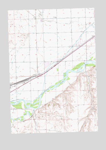
Mossmain, MT USGS Topographic Map
Click on map above to begin viewing in our Map Viewer.

This topographic map contains these locations and features:
Feature Name Type Latitude Longitude GNIS ID View Map
01S24E23DDDD01 WellWellN45.7272°W108.7213°811467View Map
01S24E24DDDD01 WellWellN45.7266°W108.6996°811448View Map
01S24E25DDDC01 WellWellN45.7127°W108.7007°811346View Map
01S24E26DDAA01 WellWellN45.7144°W108.7207°811354View Map
01S24E35BCCC01 WellWellN45.7047°W108.7401°811282View Map
01S24E36CCBC01 WellWellN45.6997°W108.7188°811243View Map
01S25E15CCCC01 WellWellN45.7408°W108.6376°811573View Map
01S25E16CBCC01 WellWellN45.7444°W108.6576°811602View Map
01S25E17CCDD01 WellWellN45.7408°W108.6749°811574View Map
01S25E18CCCC01 WellWellN45.7411°W108.6982°811575View Map
01S25E21CBBB01 WellWellN45.7330°W108.6571°811506View Map
01S25E21DDDD01 WellWellN45.7261°W108.6382°811444View Map
01S25E27CBBC01 WellWellN45.7175°W108.6365°811375View Map
01S25E27CCCC01 WellWellN45.7119°W108.6374°811339View Map
01S25E29AAAA01 WellWellN45.7258°W108.6599°811441View Map
01S25E29BBCB01 WellWellN45.7238°W108.6785°811430View Map
01S25E29DDDD01 WellWellN45.7125°W108.6593°811342View Map
01S25E31ADAD01 WellWellN45.7069°W108.6801°811306View Map
01S25E32DAAA01 WellWellN45.7033°W108.6585°811277View Map
02S24E01AAAB01 WellWellN45.6966°W108.7018°811212View Map
02S24E02DADD01 WellWellN45.6872°W108.7201°811125View Map
02S24E03DADA01 WellWellN45.6877°W108.7410°811138View Map
02S24E12A___01 WellWellN45.6797°W108.7038°811062View Map
02S24E12AABB01 WellWellN45.6825°W108.7035°811095View Map
02S24E12BBBD01 WellWellN45.6811°W108.7176°811089View Map
02S24E12CCAD01 WellWellN45.6705°W108.7160°810999View Map
02S24E13DDAA01 WellWellN45.6566°W108.6996°810868View Map
02S24E14ABBB01 WellWellN45.6677°W108.7299°810971View Map
02S24E15DADA01 WellWellN45.6583°W108.7410°810876View Map
02S24E22A___01 WellWellN45.6505°W108.7449°810804View Map
02S24E23ACAA01 WellWellN45.6497°W108.7260°810800View Map
02S25E04AACB01 WellWellN45.6950°W108.6426°811201View Map
02S25E04BCBD01 WellWellN45.6919°W108.6565°811184View Map
02S25E04CCCB01 WellWellN45.6833°W108.6518°811096View Map
02S25E06ACDC01 WellWellN45.6900°W108.6854°811159View Map
02S25E07BCBC01 WellWellN45.6772°W108.6985°811052View Map
02S25E07DDBB01 WellWellN45.6705°W108.6829°810998View Map
02S25E15C___01 WellWellN45.6563°W108.6276°810864View Map
02S25E18BBBC01 WellWellN45.6652°W108.6988°810947View Map
Canyon Creek DitchCanalN45.6719°W108.7296°769576View Map
Clarks Fork Yellowstone RiverStreamN45.6499°W108.7151°798974View Map
Davis CreekStreamN45.6372°W108.7465°770472View Map
Davis DitchCanalN45.6497°W108.7385°770475View Map
Dry CreekStreamN45.6505°W108.7099°770782View Map
Duck CreekStreamN45.6869°W108.6440°770862View Map
East Fork Duck CreekStreamN45.6494°W108.6321°771036View Map
Elder Grove SchoolSchoolN45.7413°W108.6799°771164View Map
HesperPopulated PlaceN45.7419°W108.7096°772359View Map
High DitchCanalN45.7055°W108.7396°772386View Map
Laurel DivisionCivilN45.7060°W108.7189°1940656View Map
Laurel StockyardsLocaleN45.6766°W108.7290°773256View Map
Line CreekStreamN45.6650°W108.6743°773375View Map
MossmainPopulated PlaceN45.6847°W108.7110°774416View Map
Riverside Park Boat RampLocaleN45.6536°W108.7488°1744261View Map
Spring CreekStreamN45.6486°W108.7163°777016View Map

Note: Coordinates in the location and feature list above are referenced to NAD83 datum.


Copyright (C) 2008-2024 Ryan Niemi / Sunset Dynamics ... All Rights Reserved