TopoQuest Logo
Do you find TopoQuest useful?
Help keep TopoQuest running and adding new maps/features by donating!
Bitcoin:  19c7KJd3qBynnjoSw5npx9KScwjBe4ifkT
Litecoin:  LXs6TkuXGGXo1vDsWCkWVdjQX94eUKd6ui
Home View Maps Find Maps Find Places Resources & Links


Mount Airy North, North Carolina Topographic Map

USGS Map Title: Mount Airy North, NC
USGS Map MRC: 36080E5
DRG (GeoTIFF) Download: o36080e5.tif


Neighboring USGS Topographic Map Quads:


  Fancy Gap, VA  
36080F6
 

  Laurel Fork, VA  
36080F5
 

  Meadows of Dan, VA  
36080F4
 

  Cana, VA  
36080E6
 

  Mount Airy North, NC  
36080E5
 

  Claudville, VA  
36080E4
 

  Dobson, NC  
36080D6
 

  Mount Airy South, NC  
36080D5
 

  Pilot Mountain, NC  
36080D4


Map MRC Location:

N37°
W81°
N37°
W80°
H8 H7 H6 H5 H4 H3 H2 H1
G8 G7 G6 G5 G4 G3 G2 G1
F8 F7 F6 F5 F4 F3 F2 F1
E8 E7 E6 E5 E4 E3 E2 E1
D8 D7 D6 D5 D4 D3 D2 D1
C8 C7 C6 C5 C4 C3 C2 C1
B8 B7 B6 B5 B4 B3 B2 B1
A8 A7 A6 A5 A4 A3 A2 A1
N36°
W81°
N36°
W80°

Mount Airy North, NC USGS 1:24K Topographic Map Preview:
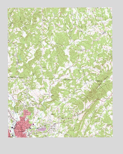
Mount Airy North, NC USGS Topographic Map
Click on map above to begin viewing in our Map Viewer.

This topographic map contains these locations and features:
Feature Name Type Latitude Longitude GNIS ID View Map
AraratPopulated PlaceN36.5990°W80.5106°1462535View Map
Ararat CemeteryCemeteryN36.6201°W80.5848°1497924View Map
Ararat CemeteryCemeteryN36.5310°W80.5920°980268View Map
Ararat ChurchChurchN36.6201°W80.5840°1462536View Map
Ararat Post OfficePost OfficeN36.5992°W80.5101°2766150View Map
Ararat Rescue SquadBuildingN36.5951°W80.5153°2086078View Map
Ararat Volunteer Fire Department Station A HeadquartersBuildingN36.5991°W80.5111°2086070View Map
Ararat Volunteer Fire Department Station BBuildingN36.5941°W80.5817°2721181View Map
Birds BranchStreamN36.6007°W80.5306°1463453View Map
Blue Ridge Elementary SchoolSchoolN36.6001°W80.5102°1463585View Map
Blue Ridge TabernacleChurchN36.6024°W80.5351°1463588View Map
Blue Ridge Volunteer Rescue SquadBuildingN36.5808°W80.5839°2086079View Map
Bright Leaf Drive-In (historical)LocaleN36.5019°W80.6214°2723205View Map
Center ChurchChurchN36.5632°W80.5151°1464670View Map
Champ CreekStreamN36.5193°W80.5851°982996View Map
Chestnut RidgeRidgeN36.5240°W80.5117°983128View Map
Chestnut Ridge ChurchChurchN36.5110°W80.5059°983131View Map
City of Mount AiryCivilN36.5084°W80.6156°2404317View Map
Clarks CreekStreamN36.5682°W80.5503°1464946View Map
CombstownPopulated PlaceN36.5007°W80.5790°1731549View Map
Doe Run CemeteryCemeteryN36.6185°W80.5462°1497954View Map
Doe Run ChurchChurchN36.6185°W80.5462°1465859View Map
Doe Run CreekStreamN36.5904°W80.5490°1465860View Map
Double Spring BranchStreamN36.5668°W80.5356°984293View Map
Dry RunStreamN36.6051°W80.5362°1466009View Map
East Fork Johnson CreekStreamN36.6082°W80.6059°1466102View Map
Flat RockPopulated PlaceN36.5124°W80.5698°1020274View Map
Flat Rock Baptist ChurchChurchN36.5087°W80.5748°1731567View Map
Flat Rock Census Designated PlaceCensusN36.5076°W80.5797°2402487View Map
Flat Rock ElementarySchoolN36.5126°W80.5684°1001980View Map
Flat Rock QuarryMineN36.5076°W80.5842°1731568View Map
Flippin ChurchChurchN36.5385°W80.5531°985227View Map
Four Way Volunteer Fire Department HeadquartersBuildingN36.5129°W80.5700°2639001View Map
Fourway Volunteer Fire Department Wards Gap StationBuildingN36.5494°W80.6030°2638253View Map
Friendly TabernacleChurchN36.5218°W80.5734°985422View Map
God's Acre CemeteryCemeteryN36.5179°W80.6045°985758View Map
Gospel MissionChurchN36.5124°W80.5801°985862View Map
Grogen BranchStreamN36.6049°W80.5290°1467564View Map
Hunter ChapelChurchN36.5837°W80.5356°1468386View Map
Hunters Chapel CemeteryCemeteryN36.5835°W80.5364°1497971View Map
Johnson CreekStreamN36.5362°W80.5809°987673View Map
Jones ChurchChurchN36.5515°W80.5331°987742View Map
Jones Elementary SchoolSchoolN36.5310°W80.6031°1024834View Map
King Noahs BranchStreamN36.5854°W80.5103°1469009View Map
Kings RunStreamN36.5907°W80.5484°1469022View Map
Koners Grove ChurchChurchN36.5362°W80.5581°988061View Map
Long BranchStreamN36.5668°W80.5306°1469797View Map
Long Branch MountainSummitN36.5532°W80.5120°1495867View Map
Midkiff CemeteryCemeteryN36.5040°W80.5640°989815View Map
Mire BranchStreamN36.6040°W80.5506°1470625View Map
Mount Airy Annex Post OfficePost OfficeN36.5042°W80.6057°2780609View Map
Mount Airy Fire Department Station 2BuildingN36.5149°W80.6053°2638959View Map
Mount Airy High SchoolSchoolN36.5115°W80.6153°1001988View Map
Mount Airy Junior High SchoolSchoolN36.5137°W80.6156°1001989View Map
Mount Airy QuarryMineN36.5081°W80.5847°2649230View Map
Mount Airy Rescue SquadBuildingN36.5039°W80.6216°2720506View Map
Mount Ararat ChurchChurchN36.6140°W80.5117°1497991View Map
Mount Bethel SchoolSchoolN36.5935°W80.6245°1470815View Map
Mount Calvary ChurchChurchN36.5007°W80.5795°990340View Map
Mountain View CemeteryCemeteryN36.6129°W80.5828°1497992View Map
Mountain View ChurchChurchN36.6129°W80.5817°1471191View Map
Oakdale CemeteryCemeteryN36.5187°W80.6021°991457View Map
Owens BranchStreamN36.5835°W80.5570°1471989View Map
Payne's Chapel Baptist ChurchChurchN36.5182°W80.5606°991957View Map
Paynetown Community CemeteryCemeteryN36.5182°W80.5606°2037707View Map
Pedigo CemeteryCemeteryN36.5660°W80.5503°1472168View Map
Pleasant View ChurchChurchN36.5212°W80.5456°992583View Map
Pleasant View ChurchChurchN36.5315°W80.5937°992584View Map
Raven Rock ChurchChurchN36.6215°W80.5006°1473022View Map
Reeves Community CenterBuildingN36.5043°W80.5965°1001999View Map
Riverside ParkParkN36.5054°W80.6017°1002001View Map
Rocky CreekStreamN36.5107°W80.6215°1731648View Map
Rye Stack BranchStreamN36.5662°W80.5406°1473672View Map
SalemPopulated PlaceN36.5382°W80.6012°994154View Map
Salem Baptist ChurchChurchN36.5424°W80.6026°994180View Map
Salem CemeteryCemeteryN36.5432°W80.6026°1731655View Map
Samuels Grove ChurchChurchN36.5671°W80.5840°1473989View Map
School House CreekStreamN36.5387°W80.6215°1731656View Map
Slate MountainSummitN36.5401°W80.5223°1474671View Map
Slate MountainPopulated PlaceN36.5371°W80.5059°1731667View Map
Slate MountainSummitN36.5429°W80.5151°1022655View Map
Slate Mountain Baptist ChurchChurchN36.5368°W80.5059°994904View Map
State Line CemeteryCemeteryN36.5582°W80.6117°1738425View Map
Stateline ChurchChurchN36.5576°W80.6112°995437View Map
Sulphur SpringsPopulated PlaceN36.5399°W80.5745°1022834View Map
Sun RunStreamN36.6140°W80.5037°1475325View Map
The HollowLocaleN36.5840°W80.5353°1475582View Map
Township of Mount AiryCivilN36.5004°W80.6023°1027217View Map
Veterans Memorial ParkParkN36.5151°W80.6184°1002007View Map
Wards Gap ChurchChurchN36.5787°W80.6145°1476318View Map
Willis Gap CemeteryCemeteryN36.5923°W80.5851°1498015View Map
Willis Gap ChurchChurchN36.5918°W80.5840°1476781View Map

Note: Coordinates in the location and feature list above are referenced to NAD83 datum.


Copyright (C) 2008-2024 Ryan Niemi / Sunset Dynamics ... All Rights Reserved