TopoQuest Logo
Do you find TopoQuest useful?
Help keep TopoQuest running and adding new maps/features by donating!
Bitcoin:  19c7KJd3qBynnjoSw5npx9KScwjBe4ifkT
Litecoin:  LXs6TkuXGGXo1vDsWCkWVdjQX94eUKd6ui
Home View Maps Find Maps Find Places Resources & Links


Mount Kineo, Maine Topographic Map

USGS Map Title: Mount Kineo, ME
USGS Map MRC: 45069F6
DRG (GeoTIFF) Download: o45069f6.tif


Neighboring USGS Topographic Map Quads:


  Socatean Bay, ME  
45069G7
 

  North East Carry, ME  
45069G6
 

  Lobster Mountain, ME  
45069G5
 

  Brassua Lake East, ME  
45069F7
 

  Mount Kineo, ME  
45069F6
 

  Spencer Bay, ME  
45069F5
 

  Indian Pond North, ME  
45069E7
 

  Moosehead, ME  
45069E6
 

  Lily Bay, ME  
45069E5


Map MRC Location:

N46°
W70°
N46°
W69°
H8 H7 H6 H5 H4 H3 H2 H1
G8 G7 G6 G5 G4 G3 G2 G1
F8 F7 F6 F5 F4 F3 F2 F1
E8 E7 E6 E5 E4 E3 E2 E1
D8 D7 D6 D5 D4 D3 D2 D1
C8 C7 C6 C5 C4 C3 C2 C1
B8 B7 B6 B5 B4 B3 B2 B1
A8 A7 A6 A5 A4 A3 A2 A1
N45°
W70°
N45°
W69°

Mount Kineo, ME USGS 1:24K Topographic Map Preview:
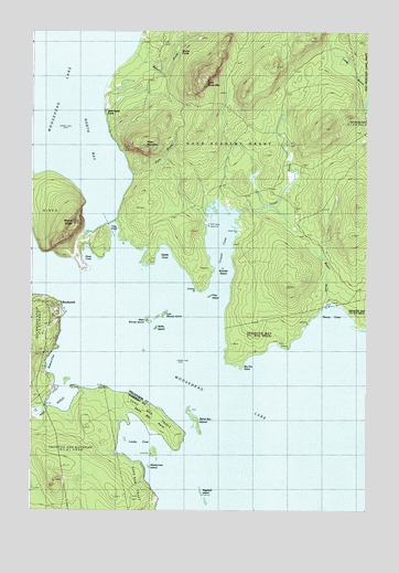
Mount Kineo, ME USGS Topographic Map
Click on map above to begin viewing in our Map Viewer.

This topographic map contains these locations and features:
Feature Name Type Latitude Longitude GNIS ID View Map
Barrows CoveBayN45.6614°W69.7426°561648View Map
Beaver BrookStreamN45.7428°W69.7134°561905View Map
Beaver PondsLakeN45.7459°W69.6906°561966View Map
Big Dry PointCapeN45.6625°W69.6709°562158View Map
Boulder IslandIslandN45.6881°W69.6778°562776View Map
Cowan BrookStreamN45.7025°W69.6720°564424View Map
Cowan CoveBayN45.6945°W69.6798°564426View Map
Cowan PointCapeN45.6825°W69.6867°564427View Map
Days Academy Grant TownshipCivilN45.7308°W69.6746°1987333View Map
Deer Head FarmLocaleN45.7331°W69.7209°564976View Map
East Moody IslandIslandN45.6756°W69.7006°565641View Map
Farm BrookStreamN45.7112°W69.7114°566035View Map
Frog PondLakeN45.6973°W69.7187°566606View Map
Harris CoveBayN45.6920°W69.7001°567688View Map
Hogback IslandIslandN45.6303°W69.6859°568173View Map
Kineo CoveBayN45.6917°W69.7298°569189View Map
Kineo TownshipCivilN45.7014°W69.7407°1987340View Map
Lambs CoveBayN45.6409°W69.7084°569345View Map
Little Kineo MountainSummitN45.7370°W69.6853°569863View Map
Masterman IslandIslandN45.6362°W69.7053°570886View Map
Mount KineoSummitN45.6998°W69.7339°569191View Map
Pine IslandIslandN45.6809°W69.6828°573389View Map
RockwoodPopulated PlaceN45.6778°W69.7409°574365View Map
Rockwood Fire and Rescue DepartmentBuildingN45.6712°W69.7445°2553050View Map
Ronco BrookStreamN45.6795°W69.6378°574445View Map
Ronco CoveBayN45.6773°W69.6370°574446View Map
Sand Bar IslandIslandN45.6492°W69.6887°574820View Map
Sand Bar PointCapeN45.6450°W69.6970°574821View Map
Sandbar Tract TownshipCivilN45.6501°W69.7050°2748750View Map
Shaw MountainSummitN45.7198°W69.7088°575329View Map
West Moody IslandIslandN45.6745°W69.7064°578174View Map
West Outlet DamDamN45.6523°W69.7443°1773673View Map
Willis IslandIslandN45.6723°W69.7028°578528View Map

Note: Coordinates in the location and feature list above are referenced to NAD83 datum.


Copyright (C) 2008-2024 Ryan Niemi / Sunset Dynamics ... All Rights Reserved