TopoQuest Logo
Do you find TopoQuest useful?
Help keep TopoQuest running and adding new maps/features by donating!
Bitcoin:  19c7KJd3qBynnjoSw5npx9KScwjBe4ifkT
Litecoin:  LXs6TkuXGGXo1vDsWCkWVdjQX94eUKd6ui
Home View Maps Find Maps Find Places Resources & Links


Muncy, Pennsylvania Topographic Map

USGS Map Title: Muncy, PA
USGS Map MRC: 41076B7
DRG (GeoTIFF) Download: o41076b7.tif


Neighboring USGS Topographic Map Quads:


  Montoursville North, PA  
41076C8
 

  Huntersville, PA  
41076C7
 

  Picture Rocks, PA  
41076C6
 

  Montoursville South, PA  
41076B8
 

  Muncy, PA  
41076B7
 

  Hughesville, PA  
41076B6
 

  Allenwood, PA  
41076A8
 

  Milton, PA  
41076A7
 

  Washingtonville, PA  
41076A6


Map MRC Location:

N42°
W77°
N42°
W76°
H8 H7 H6 H5 H4 H3 H2 H1
G8 G7 G6 G5 G4 G3 G2 G1
F8 F7 F6 F5 F4 F3 F2 F1
E8 E7 E6 E5 E4 E3 E2 E1
D8 D7 D6 D5 D4 D3 D2 D1
C8 C7 C6 C5 C4 C3 C2 C1
B8 B7 B6 B5 B4 B3 B2 B1
A8 A7 A6 A5 A4 A3 A2 A1
N41°
W77°
N41°
W76°

Muncy, PA USGS 1:24K Topographic Map Preview:
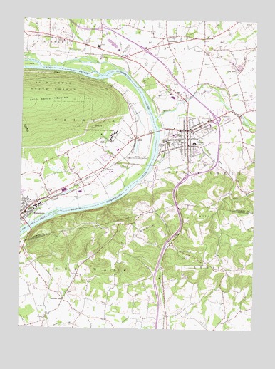
Muncy, PA USGS Topographic Map
Click on map above to begin viewing in our Map Viewer.

This topographic map contains these locations and features:
Feature Name Type Latitude Longitude GNIS ID View Map
Borough of MontgomeryCivilN41.1710°W76.8739°1215422View Map
Borough of MuncyCivilN41.2022°W76.7855°1215424View Map
Carpenters RunStreamN41.2276°W76.8163°1171251View Map
ChippewaPopulated PlaceN41.2379°W76.7769°1203271View Map
Clinton CemeteryCemeteryN41.1770°W76.8578°1172016View Map
Davis SchoolSchoolN41.2231°W76.8269°1197435View Map
Delaware RunPopulated PlaceN41.1367°W76.8511°1173126View Map
Dividing Ridge SchoolSchoolN41.1523°W76.7763°1197438View Map
Dry RunStreamN41.2429°W76.8133°1173552View Map
Fairview SchoolSchoolN41.2131°W76.7550°1197436View Map
Glade RunStreamN41.2073°W76.8008°1175663View Map
Glade Run SchoolSchoolN41.1862°W76.7597°1197437View Map
HallsLocaleN41.2356°W76.8172°1176402View Map
Halls StationLocaleN41.2345°W76.8211°1212577View Map
Hey Field (historical)AirportN41.2417°W76.7636°1194202View Map
Immanuel ChurchChurchN41.2184°W76.7552°1177712View Map
King IslandIslandN41.2320°W76.8722°1190980View Map
Lime BluffPopulated PlaceN41.2295°W76.7605°1204025View Map
Lime Bluff QuarryMineN41.2339°W76.7625°2706950View Map
Margaret RunStreamN41.2356°W76.8211°1180400View Map
Mountain School (historical)SchoolN41.1979°W76.8475°1197434View Map
MuncyPopulated PlaceN41.2056°W76.7855°1213993View Map
Muncy Area Volunteer Fire CompanyBuildingN41.2045°W76.7859°2652972View Map
Muncy Borough Police DepartmentBuildingN41.2064°W76.7850°2780526View Map
Muncy CemeteryCemeteryN41.2040°W76.7800°1182082View Map
Muncy Industrial Home for WomenBuildingN41.2026°W76.8255°1212578View Map
Muncy Post OfficePost OfficeN41.2038°W76.7858°2772855View Map
Muncy ReservoirReservoirN41.1918°W76.7761°1182083View Map
Muncy StationLocaleN41.2020°W76.8127°1182084View Map
Muncy Township Volunteer Fire CompanyBuildingN41.2421°W76.8011°2652999View Map
Muncy Valley HospitalHospitalN41.2098°W76.7753°1182086View Map
Oak RunStreamN41.2409°W76.7730°1182798View Map
PennsdalePopulated PlaceN41.2431°W76.7966°1183523View Map
Pilgrim ChurchChurchN41.1398°W76.8497°1183742View Map
Pleasant View ChurchChurchN41.2126°W76.7652°1184092View Map
Road SchoolSchoolN41.2442°W76.8750°1197420View Map
SaegersPopulated PlaceN41.1892°W76.8291°1204572View Map
Saint Johns ChurchChurchN41.1290°W76.8616°1186168View Map
State Correctional Institution MuncyBuildingN41.2026°W76.8237°2757220View Map
Stony Batter SchoolSchoolN41.1423°W76.8697°1197433View Map
Township of Muncy CreekCivilN41.1933°W76.7622°1216764View Map
Trinity ChurchChurchN41.2434°W76.7925°1189810View Map
Tules RunStreamN41.2312°W76.8566°1189909View Map
Turkey RunStreamN41.1826°W76.8180°1189947View Map
Turkey RunStreamN41.2401°W76.8400°1189950View Map
Twin Hills Memorial ParkCemeteryN41.2454°W76.8588°1213385View Map
Twin RunStreamN41.2331°W76.8308°1190015View Map
Warrior SchoolSchoolN41.1304°W76.7947°1197440View Map
West Point SchoolSchoolN41.1670°W76.8197°1197439View Map
Wolf RunStreamN41.2115°W76.8013°1190963View Map

Note: Coordinates in the location and feature list above are referenced to NAD83 datum.


Copyright (C) 2008-2025 Ryan Niemi / Sunset Dynamics ... All Rights Reserved