TopoQuest Logo
Do you find TopoQuest useful?
Help keep TopoQuest running and adding new maps/features by donating!
Bitcoin:  19c7KJd3qBynnjoSw5npx9KScwjBe4ifkT
Litecoin:  LXs6TkuXGGXo1vDsWCkWVdjQX94eUKd6ui
Home View Maps Find Maps Find Places Resources & Links


Ozark, Missouri Topographic Map

USGS Map Title: Ozark, MO
USGS Map MRC: 37093A2
DRG (GeoTIFF) Download: o37093a2.tif


Neighboring USGS Topographic Map Quads:


  Springfield, MO  
37093B3
 

  Galloway, MO  
37093B2
 

  Oak Grove Heights, MO  
37093B1
 

  Nixa, MO  
37093A3
 

  Ozark, MO  
37093A2
 

  Rogersville, MO  
37093A1
 

  Highlandville, MO  
36093H3
 

  Selmore, MO  
36093H2
 

  Chadwick, MO  
36093H1


Map MRC Location:

N38°
W94°
N38°
W93°
H8 H7 H6 H5 H4 H3 H2 H1
G8 G7 G6 G5 G4 G3 G2 G1
F8 F7 F6 F5 F4 F3 F2 F1
E8 E7 E6 E5 E4 E3 E2 E1
D8 D7 D6 D5 D4 D3 D2 D1
C8 C7 C6 C5 C4 C3 C2 C1
B8 B7 B6 B5 B4 B3 B2 B1
A8 A7 A6 A5 A4 A3 A2 A1
N37°
W94°
N37°
W93°

Ozark, MO USGS 1:24K Topographic Map Preview:
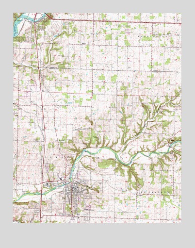
Ozark, MO USGS Topographic Map
Click on map above to begin viewing in our Map Viewer.

This topographic map contains these locations and features:
Feature Name Type Latitude Longitude GNIS ID View Map
Air Park South (historical)AirportN37.0598°W93.2357°758846View Map
Carter HollowValleyN37.0437°W93.1313°715446View Map
CassidyPopulated PlaceN37.0676°W93.2463°740728View Map
Center Point ChurchChurchN37.1053°W93.1474°715647View Map
Chapman CemeteryCemeteryN37.0237°W93.2202°715733View Map
Christian County Sheriff's OfficeBuildingN37.0198°W93.2055°2752157View Map
City of OzarkCivilN37.0361°W93.2154°2396121View Map
CowanPopulated PlaceN37.0781°W93.1730°740517View Map
Cowan School (historical)SchoolN37.0756°W93.1621°733154View Map
Fremont HillsPopulated PlaceN37.0651°W93.2488°1669600View Map
Fulton CemeteryCemeteryN37.0920°W93.1646°718292View Map
Gardner AirportAirportN37.1138°W93.2045°2679391View Map
Garrison BranchStreamN37.0246°W93.2075°718357View Map
Garrison CemeteryCemeteryN37.0237°W93.1857°718359View Map
Gibson-Porter CemeteryCemeteryN37.0989°W93.2116°718431View Map
Hedges SpurLocaleN37.0192°W93.1757°740516View Map
Hopedale ChurchChurchN37.0692°W93.2182°719791View Map
Hopedale School (historical)SchoolN37.0695°W93.2102°733155View Map
Hopewell CemeteryCemeteryN37.1123°W93.1360°719793View Map
Hunt BranchStreamN37.0926°W93.2255°720001View Map
Kelly CemeteryCemeteryN37.1128°W93.1893°720513View Map
KSWM-AM (Republic)TowerN37.0620°W93.1277°754263View Map
LindenPopulated PlaceN37.0464°W93.1341°735693View Map
Linden AirAirportN37.0581°W93.1483°2679375View Map
Linden ChapelChurchN37.0417°W93.1316°721099View Map
Lindenlure LakeReservoirN37.0464°W93.1327°721104View Map
McCauley CemeteryCemeteryN37.0234°W93.2477°722039View Map
McCrackenPopulated PlaceN37.0176°W93.1580°722064View Map
Melton SpringSpringN37.0148°W93.2107°722211View Map
MentorPopulated PlaceN37.1062°W93.1991°722234View Map
Missouri State Veterans Cemetery - SpringfieldCemeteryN37.1181°W93.2385°2776796View Map
Mooney HollowValleyN37.0717°W93.1343°722559View Map
Mount Pleasant School (historical)SchoolN37.0970°W93.2416°732722View Map
Mount Zion ChurchChurchN37.0139°W93.1593°722947View Map
OzarkPopulated PlaceN37.0209°W93.2060°723933View Map
Ozark Fire Protection District Station 1BuildingN37.0247°W93.2061°2620953View Map
Ozark Fire Protection District Station 2BuildingN37.0699°W93.2330°2620616View Map
Ozark Fire Protection District Station 4BuildingN37.0165°W93.1308°2621616View Map
Ozark Police DepartmentBuildingN37.0214°W93.2053°2752583View Map
Ozark Post OfficePost OfficeN37.0243°W93.2207°2782760View Map
Palace (historical)Populated PlaceN37.1209°W93.1646°740514View Map
Parched Corn CreekStreamN37.0414°W93.1743°733158View Map
Parched Corn HollowValleyN37.0420°W93.1732°724006View Map
PembinaPopulated PlaceN37.1078°W93.1496°755648View Map
Pembina CemeteryCemeteryN37.0823°W93.1293°724189View Map
Porter CemeteryCemeteryN37.0045°W93.2135°724761View Map
Richwood BranchStreamN37.0151°W93.2449°725282View Map
Richwood CemeteryCemeteryN37.0387°W93.2488°725283View Map
Riverside LandingsAirportN37.0313°W93.1661°758847View Map
Saint Joseph ChurchChurchN37.0342°W93.2093°725800View Map
Smith CemeteryCemeteryN37.1034°W93.1291°726584View Map
Smyrna ChurchChurchN37.0537°W93.1543°726647View Map
Thompson CreekStreamN37.1234°W93.2488°736189View Map
Tilman School (historical)SchoolN37.0137°W93.1580°733156View Map
Township of CassidyCivilN37.0574°W93.2403°2397781View Map
Township of Clay BCivilN37.1243°W93.1932°1990068View Map
Township of Finley (historical)CivilN37.0195°W93.2077°766475View Map
Township of RiversideCivilN37.0628°W93.1977°2397863View Map
Vaughn CemeteryCemeteryN37.0045°W93.1938°728153View Map
Weaver CemeteryCemeteryN37.0495°W93.2163°728445View Map
Whites Spur (historical)LocaleN37.0092°W93.1268°740515View Map
Wolf School (historical)SchoolN37.1053°W93.1443°732723View Map

Note: Coordinates in the location and feature list above are referenced to NAD83 datum.


Copyright (C) 2008-2024 Ryan Niemi / Sunset Dynamics ... All Rights Reserved