TopoQuest Logo
Do you find TopoQuest useful?
Help keep TopoQuest running and adding new maps/features by donating!
Bitcoin:  19c7KJd3qBynnjoSw5npx9KScwjBe4ifkT
Litecoin:  LXs6TkuXGGXo1vDsWCkWVdjQX94eUKd6ui
Home View Maps Find Maps Find Places Resources & Links


Highlandville, Missouri Topographic Map

USGS Map Title: Highlandville, MO
USGS Map MRC: 36093H3
DRG (GeoTIFF) Download: o36093h3.tif


Neighboring USGS Topographic Map Quads:


  Republic, MO  
37093A4
 

  Nixa, MO  
37093A3
 

  Ozark, MO  
37093A2
 

  Hurley, MO  
36093H4
 

  Highlandville, MO  
36093H3
 

  Selmore, MO  
36093H2
 

  Galena, MO  
36093G4
 

  Spokane, MO  
36093G3
 

  Day, MO  
36093G2


Map MRC Location:

N37°
W94°
N37°
W93°
H8 H7 H6 H5 H4 H3 H2 H1
G8 G7 G6 G5 G4 G3 G2 G1
F8 F7 F6 F5 F4 F3 F2 F1
E8 E7 E6 E5 E4 E3 E2 E1
D8 D7 D6 D5 D4 D3 D2 D1
C8 C7 C6 C5 C4 C3 C2 C1
B8 B7 B6 B5 B4 B3 B2 B1
A8 A7 A6 A5 A4 A3 A2 A1
N36°
W94°
N36°
W93°

Highlandville, MO USGS 1:24K Topographic Map Preview:
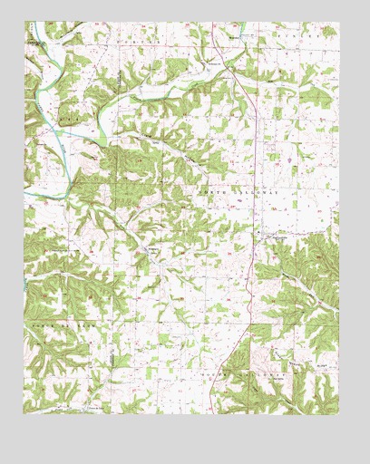
Highlandville, MO USGS Topographic Map
Click on map above to begin viewing in our Map Viewer.

This topographic map contains these locations and features:
Feature Name Type Latitude Longitude GNIS ID View Map
BengalPopulated PlaceN36.9006°W93.3099°755598View Map
Bud SpringSpringN36.8867°W93.2766°714994View Map
City of HighlandvilleCivilN36.9409°W93.2830°2394378View Map
Collins CemeteryCemeteryN36.9820°W93.2546°716126View Map
Craig HollowValleyN36.9631°W93.3410°716456View Map
Eastern Star School (historical)SchoolN36.9981°W93.2674°733166View Map
Finley CreekStreamN36.9651°W93.3627°717922View Map
Flood CemeteryCemeteryN36.9270°W93.3566°718033View Map
Flood School (historical)SchoolN36.9248°W93.3582°732905View Map
Glenn CemeteryCemeteryN36.9837°W93.3021°718514View Map
Green Mound RidgePopulated PlaceN36.8923°W93.2507°733169View Map
Hidden Valley Golf LinksLocaleN36.9821°W93.3657°2678230View Map
HighlandvillePopulated PlaceN36.9328°W93.2805°735649View Map
Highlandville Fire Protection District Station 1BuildingN36.9126°W93.2847°2620382View Map
Highlandville Fire Protection District Station 3BuildingN36.9708°W93.2840°2621265View Map
Highlandville Independent Order of Odd Fellows CemeteryCemeteryN36.9322°W93.2659°2681449View Map
Highlandville Post OfficePost OfficeN36.9333°W93.2810°2782648View Map
Highlandville SchoolSchoolN36.9334°W93.2821°733168View Map
Hog CreekStreamN36.9870°W93.2938°750357View Map
JamesvillePopulated PlaceN36.9601°W93.3710°740962View Map
Jamesville School (historical)SchoolN36.9656°W93.3657°732906View Map
Jones Chastain CemeteryCemeteryN36.9823°W93.2930°720407View Map
Lebow CemeteryCemeteryN36.8998°W93.3132°720876View Map
Line School (historical)SchoolN36.9934°W93.3421°733165View Map
Martin CemeteryCemeteryN36.8895°W93.2971°721921View Map
Mayberry CemeteryCemeteryN36.9156°W93.3213°722003View Map
McCafferty HollowValleyN36.9934°W93.3610°722030View Map
MontaguePopulated PlaceN36.9281°W93.3280°722534View Map
Nixa Fire Protection District Station 4BuildingN36.9943°W93.3428°2621119View Map
Pleasant View ChurchChurchN36.9270°W93.3574°724642View Map
Ponce de LeonPopulated PlaceN36.8759°W93.3516°724727View Map
RiverdalePopulated PlaceN36.9953°W93.2899°725341View Map
Riverdale ChurchChurchN36.9870°W93.3024°725342View Map
Tory CemeteryCemeteryN36.9359°W93.3352°727718View Map
Tory CreekStreamN36.9442°W93.3585°727719View Map
Tory Creek School (historical)SchoolN36.9264°W93.3255°733167View Map
Township of North GallowayCivilN36.9398°W93.2747°766481View Map
Township of Ponce de LeonCivilN36.8928°W93.3725°767434View Map
White CemeteryCemeteryN36.9573°W93.2655°728713View Map
Wolfden BranchStreamN36.9778°W93.3702°729074View Map

Note: Coordinates in the location and feature list above are referenced to NAD83 datum.


Copyright (C) 2008-2024 Ryan Niemi / Sunset Dynamics ... All Rights Reserved