TopoQuest Logo
Do you find TopoQuest useful?
Help keep TopoQuest running and adding new maps/features by donating!
Bitcoin:  19c7KJd3qBynnjoSw5npx9KScwjBe4ifkT
Litecoin:  LXs6TkuXGGXo1vDsWCkWVdjQX94eUKd6ui
Home View Maps Find Maps Find Places Resources & Links


Parsons East, Kansas Topographic Map

USGS Map Title: Parsons East, KS
USGS Map MRC: 37095C2
DRG (GeoTIFF) Download: o37095c2.tif


Neighboring USGS Topographic Map Quads:


  Galesburg, KS  
37095D3
 

  South Mound, KS  
37095D2
 

  McCune NE, KS  
37095D1
 

  Parsons West, KS  
37095C3
 

  Parsons East, KS  
37095C2
 

  McCune, KS  
37095C1
 

  Altamont, KS  
37095B3
 

  Labette, KS  
37095B2
 

  Oswego, KS  
37095B1


Map MRC Location:

N38°
W96°
N38°
W95°
H8 H7 H6 H5 H4 H3 H2 H1
G8 G7 G6 G5 G4 G3 G2 G1
F8 F7 F6 F5 F4 F3 F2 F1
E8 E7 E6 E5 E4 E3 E2 E1
D8 D7 D6 D5 D4 D3 D2 D1
C8 C7 C6 C5 C4 C3 C2 C1
B8 B7 B6 B5 B4 B3 B2 B1
A8 A7 A6 A5 A4 A3 A2 A1
N37°
W96°
N37°
W95°

Parsons East, KS USGS 1:24K Topographic Map Preview:
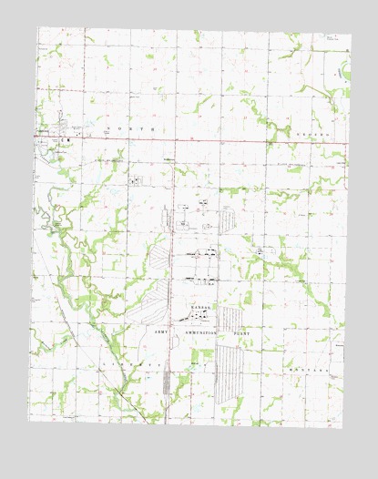
Parsons East, KS USGS Topographic Map
Click on map above to begin viewing in our Map Viewer.

This topographic map contains these locations and features:
Feature Name Type Latitude Longitude GNIS ID View Map
Bachelor CreekStreamN37.2803°W95.2250°469793View Map
BrownstonePopulated PlaceN37.3328°W95.1941°484483View Map
Center Bethel ChurchChurchN37.2518°W95.2315°469762View Map
Center Bethel School (historical)SchoolN37.2595°W95.2408°483699View Map
Center ChapelChurchN37.3401°W95.1577°469766View Map
Concord School (historical)SchoolN37.3662°W95.1583°483701View Map
Fairview CemeteryCemeteryN37.2963°W95.1409°469767View Map
Fairview School (historical)SchoolN37.3106°W95.1316°483713View Map
Franklin CemeteryCemeteryN37.3185°W95.1750°469765View Map
Franklin School (historical)SchoolN37.3356°W95.1761°483715View Map
Kansas Army Ammunition PlantMilitaryN37.2852°W95.1788°2512250View Map
KLKC - FM (Parsons)BuildingN37.3431°W95.2320°2625292View Map
KLKC-AM (Parsons)TowerN37.3431°W95.2322°481549View Map
KSKC-FM (Parsons)TowerN37.3431°W95.2322°481483View Map
LanevillePopulated PlaceN37.3328°W95.1266°484484View Map
Liberty School (historical)SchoolN37.2745°W95.1950°483728View Map
Little Bachelor CreekStreamN37.2734°W95.2455°469444View Map
Little Labette CreekStreamN37.3106°W95.2389°469794View Map
Marvel ParkParkN37.3373°W95.2461°469763View Map
Masonic CemeteryCemeteryN37.2659°W95.1308°469769View Map
Neosho Township Volunteer Fire DepartmentBuildingN37.3409°W95.1261°2111665View Map
Neosho Valley School (historical)SchoolN37.3406°W95.1308°483738View Map
Oakwood CemeteryCemeteryN37.3358°W95.2385°469764View Map
Olive (historical)LocaleN37.2962°W95.2427°483745View Map
Parsons Foursquare ChurchChurchN37.3394°W95.2290°2689989View Map
Parsons Wastewater Treatment FacilityLocaleN37.3125°W95.2428°2692074View Map
Pleasant Valley School (historical)SchoolN37.2817°W95.1583°483748View Map
Prairie Valley School (historical)SchoolN37.3628°W95.2314°483752View Map
Spring Hill School (historical)SchoolN37.2962°W95.2491°483765View Map
Stone Palace School (historical)SchoolN37.3639°W95.1947°483768View Map
Township of LibertyCivilN37.2520°W95.2127°469454View Map
Township of NorthCivilN37.3391°W95.2062°469792View Map
Wesley United Methodist ChurchChurchN37.3460°W95.2417°2689251View Map
Woods School (historical)SchoolN37.3178°W95.2119°483784View Map

Note: Coordinates in the location and feature list above are referenced to NAD83 datum.


Copyright (C) 2008-2025 Ryan Niemi / Sunset Dynamics ... All Rights Reserved