TopoQuest Logo
Do you find TopoQuest useful?
Help keep TopoQuest running and adding new maps/features by donating!
Bitcoin:  19c7KJd3qBynnjoSw5npx9KScwjBe4ifkT
Litecoin:  LXs6TkuXGGXo1vDsWCkWVdjQX94eUKd6ui
Home View Maps Find Maps Find Places Resources & Links


Oswego, Kansas Topographic Map

USGS Map Title: Oswego, KS
USGS Map MRC: 37095B1
DRG (GeoTIFF) Download: o37095b1.tif


Neighboring USGS Topographic Map Quads:


  Parsons East, KS  
37095C2
 

  McCune, KS  
37095C1
 

  West Mineral, KS  
37094C8
 

  Labette, KS  
37095B2
 

  Oswego, KS  
37095B1
 

  Hallowell, KS  
37094B8
 

  Bartlett, KS  
37095A2
 

  Chetopa, KS  
37095A1
 

  Melrose, KS  
37094A8


Map MRC Location:

N38°
W96°
N38°
W95°
H8 H7 H6 H5 H4 H3 H2 H1
G8 G7 G6 G5 G4 G3 G2 G1
F8 F7 F6 F5 F4 F3 F2 F1
E8 E7 E6 E5 E4 E3 E2 E1
D8 D7 D6 D5 D4 D3 D2 D1
C8 C7 C6 C5 C4 C3 C2 C1
B8 B7 B6 B5 B4 B3 B2 B1
A8 A7 A6 A5 A4 A3 A2 A1
N37°
W96°
N37°
W95°

Oswego, KS USGS 1:24K Topographic Map Preview:
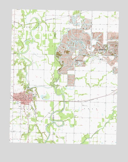
Oswego, KS USGS Topographic Map
Click on map above to begin viewing in our Map Viewer.

This topographic map contains these locations and features:
Feature Name Type Latitude Longitude GNIS ID View Map
Assembly of God ChurchChurchN37.1675°W95.1160°2688808View Map
Cherokee CemeteryCemeteryN37.1513°W95.0505°469455View Map
City of OswegoCivilN37.1674°W95.1119°485637View Map
County Farm CemeteryCemeteryN37.1284°W95.1212°469462View Map
Crain CemeteryCemeteryN37.2084°W95.1219°469467View Map
Deer CreekStreamN37.2015°W95.0389°469471View Map
Diamond School (historical)SchoolN37.1353°W95.0536°483324View Map
Dickson (historical)LocaleN37.2403°W95.0858°483705View Map
Eastside Elementary School (historical)SchoolN37.1687°W95.1055°481136View Map
First Baptist ChurchChurchN37.1680°W95.1071°2688966View Map
First Southern Baptist ChurchChurchN37.1712°W95.1149°2689031View Map
First United Presbyterian ChurchChurchN37.1663°W95.1118°2690590View Map
Friends ChurchChurchN37.2230°W95.0265°469459View Map
Friendship Friends Church CemeteryCemeteryN37.2231°W95.0258°2056971View Map
Friendship School (historical)SchoolN37.2223°W95.0314°483329View Map
Garrison CemeteryCemeteryN37.2009°W95.0514°469457View Map
Hillside Mobile Home ParkPopulated PlaceN37.1585°W95.1070°2694098View Map
HoagPopulated PlaceN37.1648°W95.0447°484446View Map
Horseshoe LakeLakeN37.1681°W95.0883°469461View Map
Labette County Ambulance ServiceBuildingN37.1658°W95.1186°2696491View Map
Labette County CourthouseBuildingN37.1655°W95.1078°2625087View Map
Labette County FairgroundsLocaleN37.1722°W95.1027°481135View Map
Labette County JailBuildingN37.1657°W95.1083°2754344View Map
Labette County Sheriff's OfficeBuildingN37.1657°W95.1079°2503942View Map
Lightning CreekStreamN37.1767°W95.0689°469472View Map
Mathews ParkParkN37.1670°W95.1002°469465View Map
McKee CemeteryCemeteryN37.2154°W95.0144°469458View Map
Mother of God Catholic ChurchChurchN37.1674°W95.1129°2689673View Map
OswegoPopulated PlaceN37.1676°W95.1100°469468View Map
Oswego Christian ChurchChurchN37.1557°W95.1096°2689134View Map
Oswego City HallBuildingN37.1663°W95.1077°2693372View Map
Oswego Community CenterBuildingN37.1717°W95.1010°2692592View Map
Oswego Community HospitalHospitalN37.1592°W95.1110°2499073View Map
Oswego Fire DepartmentBuildingN37.1662°W95.1079°2111703View Map
Oswego First United Methodist ChurchChurchN37.1691°W95.1098°2689511View Map
Oswego Golf CourseLocaleN37.1771°W95.1246°2694590View Map
Oswego High SchoolSchoolN37.1743°W95.1172°481137View Map
Oswego Historical Museum - The Log CabinBuildingN37.1684°W95.1077°2694910View Map
Oswego Middle SchoolSchoolN37.1666°W95.1027°2437484View Map
Oswego Municipal AirportAirportN37.1625°W95.0415°469456View Map
Oswego Neosho Heights Elementary SchoolSchoolN37.1704°W95.0986°469466View Map
Oswego Police DepartmentBuildingN37.1663°W95.1078°2503901View Map
Oswego Post OfficePost OfficeN37.1674°W95.1097°2693900View Map
Oswego Public LibraryBuildingN37.1668°W95.1077°2694666View Map
Oswego Public Works DepartmentBuildingN37.1682°W95.1244°2693308View Map
Pioneer School (historical)SchoolN37.1934°W95.0508°483355View Map
Redbud School (historical)SchoolN37.2381°W95.0861°483755View Map
Riverside ParkParkN37.1759°W95.1002°469460View Map
Saint Paul Lutheran ChurchChurchN37.1663°W95.1056°2689194View Map
School Number 90 (historical)SchoolN37.1642°W95.0455°483284View Map
Sherman City (historical)LocaleN37.2445°W95.0586°483365View Map
Stice School (historical)SchoolN37.1348°W95.1039°483767View Map
Sunnyview SchoolSchoolN37.1351°W95.1202°469463View Map
Tibbets CemeteryCemeteryN37.1506°W95.1041°469464View Map
Timber HillSummitN37.2298°W95.1002°469384View Map
Township of LolaCivilN37.1643°W95.0073°469277View Map
Township of OswegoCivilN37.1390°W95.1161°469303View Map
Wolf CreekStreamN37.1717°W95.0652°469470View Map

Note: Coordinates in the location and feature list above are referenced to NAD83 datum.


Copyright (C) 2008-2024 Ryan Niemi / Sunset Dynamics ... All Rights Reserved