TopoQuest Logo
Do you find TopoQuest useful?
Help keep TopoQuest running and adding new maps/features by donating!
Bitcoin:  19c7KJd3qBynnjoSw5npx9KScwjBe4ifkT
Litecoin:  LXs6TkuXGGXo1vDsWCkWVdjQX94eUKd6ui
Home View Maps Find Maps Find Places Resources & Links


Potts Creek, Virginia Topographic Map

USGS Map Title: Potts Creek, VA
USGS Map MRC: 37080E2
DRG (GeoTIFF) Download: o37080e2.tif


Neighboring USGS Topographic Map Quads:


  Glace, WV  
37080F3
 

  Alleghany, VA  
37080F2
 

  Jordan Mines, VA  
37080F1
 

  Paint Bank, VA  
37080E3
 

  Potts Creek, VA  
37080E2
 

  New Castle, VA  
37080E1
 

  Craig Springs, VA  
37080D3
 

  Looney, VA  
37080D2
 

  Catawba, VA  
37080D1


Map MRC Location:

N38°
W81°
N38°
W80°
H8 H7 H6 H5 H4 H3 H2 H1
G8 G7 G6 G5 G4 G3 G2 G1
F8 F7 F6 F5 F4 F3 F2 F1
E8 E7 E6 E5 E4 E3 E2 E1
D8 D7 D6 D5 D4 D3 D2 D1
C8 C7 C6 C5 C4 C3 C2 C1
B8 B7 B6 B5 B4 B3 B2 B1
A8 A7 A6 A5 A4 A3 A2 A1
N37°
W81°
N37°
W80°

Potts Creek, VA USGS 1:24K Topographic Map Preview:
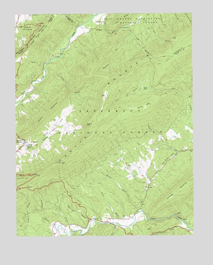
Potts Creek, VA USGS Topographic Map
Click on map above to begin viewing in our Map Viewer.

This topographic map contains these locations and features:
Feature Name Type Latitude Longitude GNIS ID View Map
Big BranchStreamN37.5143°W80.1606°1481708View Map
Cove TrailTrailN37.5796°W80.1681°1482748View Map
Hanging RockSummitN37.5626°W80.1995°1499522View Map
Hanging Rock ValleyValleyN37.5515°W80.2441°1483927View Map
Jones BranchStreamN37.5032°W80.2109°1484493View Map
Lovers LeapCliffN37.5118°W80.1367°1485101View Map
Maple Grove ChurchChurchN37.5515°W80.2420°1485171View Map
Meadow BranchStreamN37.5132°W80.1631°1485330View Map
Middle MountainSummitN37.5754°W80.2198°1485375View Map
Mount Olivet ChurchChurchN37.6218°W80.1853°1485622View Map
Mud Lick BranchStreamN37.5087°W80.1956°1485721View Map
Nutter CemeteryCemeteryN37.5112°W80.1728°1485928View Map
Nutters MountainSummitN37.5310°W80.1262°1485929View Map
Oak Grove Church (historical)ChurchN37.5048°W80.2031°1673672View Map
Paint Bank National Fish HatcheryLocaleN37.5535°W80.2448°1491212View Map
Paxton CemeteryCemeteryN37.5437°W80.1787°1673673View Map
Paxton ChapelChurchN37.5385°W80.1709°1486095View Map
Penny HollowValleyN37.5052°W80.1328°1486138View Map
Peters HillSummitN37.5032°W80.1559°1486164View Map
Potts ArmSummitN37.5737°W80.1553°1486386View Map
Potts Arm TrailTrailN37.5726°W80.1737°1486387View Map
Potts CoveFlatN37.5835°W80.1578°1486389View Map
Potts CreekPopulated PlaceN37.6204°W80.1876°1499904View Map
Potts Mountain DistrictCivilN37.5222°W80.2295°1927450View Map
Red Brush ValleyValleyN37.5470°W80.1354°1486534View Map
Rowan Memorial Home CemeteryCemeteryN37.6246°W80.2403°1552748View Map
Ruble CemeteryCemeteryN37.5651°W80.2237°1486804View Map
Ruble School (historical)SchoolN37.5054°W80.2006°1673674View Map
Shawvers Run WildernessReserveN37.5868°W80.2003°2035298View Map
Simpson BranchStreamN37.5060°W80.2201°1487253View Map
Steel Bridge CampgroundLocaleN37.6010°W80.2184°1488798View Map
Taylor BranchStreamN37.5093°W80.1659°1487784View Map
Toms KnobSummitN37.6110°W80.1387°1487952View Map
Tub RunStreamN37.5060°W80.1773°1488000View Map
Valley BranchStreamN37.5946°W80.2295°1488082View Map
Wright BranchStreamN37.5479°W80.1370°1488491View Map

Note: Coordinates in the location and feature list above are referenced to NAD83 datum.


Copyright (C) 2008-2025 Ryan Niemi / Sunset Dynamics ... All Rights Reserved