TopoQuest Logo
Do you find TopoQuest useful?
Help keep TopoQuest running and adding new maps/features by donating!
Bitcoin:  19c7KJd3qBynnjoSw5npx9KScwjBe4ifkT
Litecoin:  LXs6TkuXGGXo1vDsWCkWVdjQX94eUKd6ui
Home View Maps Find Maps Find Places Resources & Links


Paint Bank, Virginia Topographic Map

USGS Map Title: Paint Bank, VA
USGS Map MRC: 37080E3
DRG (GeoTIFF) Download: o37080e3.tif


Neighboring USGS Topographic Map Quads:


  Ronceverte, WV  
37080F4
 

  Glace, WV  
37080F3
 

  Alleghany, VA  
37080F2
 

  Gap Mills, WV  
37080E4
 

  Paint Bank, VA  
37080E3
 

  Potts Creek, VA  
37080E2
 

  Waiteville, WV  
37080D4
 

  Craig Springs, VA  
37080D3
 

  Looney, VA  
37080D2


Map MRC Location:

N38°
W81°
N38°
W80°
H8 H7 H6 H5 H4 H3 H2 H1
G8 G7 G6 G5 G4 G3 G2 G1
F8 F7 F6 F5 F4 F3 F2 F1
E8 E7 E6 E5 E4 E3 E2 E1
D8 D7 D6 D5 D4 D3 D2 D1
C8 C7 C6 C5 C4 C3 C2 C1
B8 B7 B6 B5 B4 B3 B2 B1
A8 A7 A6 A5 A4 A3 A2 A1
N37°
W81°
N37°
W80°

Paint Bank, VA USGS 1:24K Topographic Map Preview:
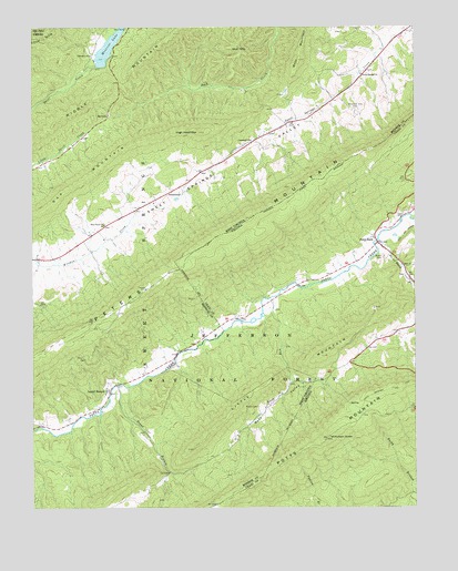
Paint Bank, VA USGS Topographic Map
Click on map above to begin viewing in our Map Viewer.

This topographic map contains these locations and features:
Feature Name Type Latitude Longitude GNIS ID View Map
Allegheny School (historical)SchoolN37.5898°W80.3137°1556629View Map
Allison Farm SpringSpringN37.5973°W80.2942°1557652View Map
Back ValleyValleyN37.5332°W80.2906°1550143View Map
Baker SpringSpringN37.5946°W80.3026°1557654View Map
Bethel Church (historical)ChurchN37.5465°W80.2937°1673663View Map
Bostic CemeteryCemeteryN37.5262°W80.3012°1550424View Map
Bryan CemeteryCemeteryN37.5651°W80.2601°1482195View Map
CentennialPopulated PlaceN37.5826°W80.3292°1554095View Map
Centennial School (historical)SchoolN37.5732°W80.3517°1556639View Map
Charles Patton SpringSpringN37.5585°W80.3692°1557659View Map
Cokesbury ChurchChurchN37.5957°W80.3031°1550754View Map
Ewin RunStreamN37.5546°W80.2970°1551074View Map
Ewin RunStreamN37.5140°W80.3142°1483321View Map
Ewin Run SpringSpringN37.5307°W80.2914°1557674View Map
Gap Mills Post OfficePost OfficeN37.5659°W80.3655°1559404View Map
High Head MountainSummitN37.5979°W80.3201°1551427View Map
High Mountain Church (historical)ChurchN37.5904°W80.2587°1673668View Map
Kitchen Creek SpringSpringN37.5571°W80.3692°1557693View Map
Laurel BranchPopulated PlaceN37.5307°W80.3498°1551697View Map
Left Fork Trout Branch SpringsSpringN37.5085°W80.3317°1557694View Map
Little MountainRidgeN37.5329°W80.2973°1551877View Map
Little MountainRidgeN37.5373°W80.2870°1484935View Map
Middle MountainRidgeN37.6087°W80.3517°1552074View Map
Moncove LakeReservoirN37.6151°W80.3381°1559162View Map
Moncove LakeReservoirN37.6199°W80.3496°1552171View Map
Moncove Lake DamDamN37.6151°W80.3534°1559161View Map
Moncove Lake Wildlife Management AreaParkN37.6221°W80.3512°1556682View Map
Mountain View CemeteryCemeteryN37.6040°W80.2701°1552237View Map
Nicholson KnobLocaleN37.5182°W80.2787°1485872View Map
Paint BankPopulated PlaceN37.5690°W80.2620°1486039View Map
Paint Bank BranchStreamN37.5698°W80.2614°1486040View Map
Paint Bank Post OfficePost OfficeN37.5685°W80.2607°2766265View Map
Paint Bank Volunteer Fire Department and Rescue SquadBuildingN37.5684°W80.2599°2086303View Map
Peters MountainRangeN37.5665°W80.3231°1486166View Map
Pine Grove ChurchChurchN37.5737°W80.3514°1552480View Map
Potts Mountain TrailTrailN37.5307°W80.2584°1486392View Map
Right Fork Trout Branch SpringSpringN37.5085°W80.3303°1557715View Map
RoxaliaPopulated PlaceN37.6023°W80.3498°1555535View Map
Roxalia School (historical)SchoolN37.5910°W80.3670°1556703View Map
Sugar Grove School (historical)SchoolN37.5315°W80.2906°1556713View Map
Sweet Springs ChurchChurchN37.6129°W80.2670°1553163View Map
Trout BranchStreamN37.5321°W80.3467°1553263View Map
Viola School (historical)SchoolN37.6212°W80.2564°1556720View Map
Wolf HillsSummitN37.6198°W80.3076°1556015View Map

Note: Coordinates in the location and feature list above are referenced to NAD83 datum.


Copyright (C) 2008-2024 Ryan Niemi / Sunset Dynamics ... All Rights Reserved