TopoQuest Logo
Do you find TopoQuest useful?
Help keep TopoQuest running and adding new maps/features by donating!
Bitcoin:  19c7KJd3qBynnjoSw5npx9KScwjBe4ifkT
Litecoin:  LXs6TkuXGGXo1vDsWCkWVdjQX94eUKd6ui
Home View Maps Find Maps Find Places Resources & Links


Sheepshead, California Topographic Map

USGS Map Title: Sheepshead, CA
USGS Map MRC: 40120G7
DRG (GeoTIFF) Download: o40120g7.tif


Neighboring USGS Topographic Map Quads:


  Silva Flat Reservoir, CA  
40120H8
 

  Said Valley, CA  
40120H7
 

  Whitinger Mountain, CA  
40120H6
 

  Bullard Lake, CA  
40120G8
 

  Sheepshead, CA  
40120G7
 

  Grasshopper Valley, CA  
40120G6
 

  Champs Flat, CA  
40120F8
 

  Spalding Tract, CA  
40120F7
 

  Troxel Point, CA  
40120F6


Map MRC Location:

N41°
W121°
N41°
W120°
H8 H7 H6 H5 H4 H3 H2 H1
G8 G7 G6 G5 G4 G3 G2 G1
F8 F7 F6 F5 F4 F3 F2 F1
E8 E7 E6 E5 E4 E3 E2 E1
D8 D7 D6 D5 D4 D3 D2 D1
C8 C7 C6 C5 C4 C3 C2 C1
B8 B7 B6 B5 B4 B3 B2 B1
A8 A7 A6 A5 A4 A3 A2 A1
N40°
W121°
N40°
W120°

Sheepshead, CA USGS 1:24K Topographic Map Preview:
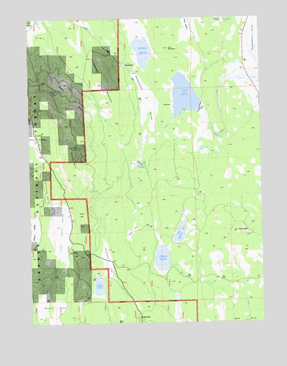
Sheepshead, CA USGS Topographic Map
Click on map above to begin viewing in our Map Viewer.

This topographic map contains these locations and features:
Feature Name Type Latitude Longitude GNIS ID View Map
Board BurnAreaN40.8435°W120.8461°219551View Map
Board Cabin SpringSpringN40.8743°W120.8715°219552View Map
Cleghorn ReservoirReservoirN40.7761°W120.8052°221205View Map
Cottonwood SpringSpringN40.8269°W120.7763°221663View Map
Coulthurst FlatFlatN40.7763°W120.8394°221670View Map
Cow Tail SpringSpringN40.8453°W120.8631°1665853View Map
Coyote HoleLakeN40.7880°W120.8204°221753View Map
Fort MountainSummitN40.8624°W120.8008°1665861View Map
Gooch CampLocaleN40.7799°W120.8558°224306View Map
Gooch MountainSummitN40.7935°W120.8463°1658634View Map
Heath Dam ReservoirReservoirN40.8432°W120.7907°1665866View Map
Heath Reservoir 250-004 DamDamN40.8385°W120.7836°1663806View Map
Heavey MountainSummitN40.7877°W120.7636°225108View Map
Horse Camp SpringSpringN40.8208°W120.7842°225592View Map
Horse Meadow ReservoirReservoirN40.8740°W120.7707°1665869View Map
Indian WellLocaleN40.7527°W120.8177°225918View Map
Little Cleghorn ReservoirReservoirN40.7865°W120.7955°227226View Map
Loveland GulchValleyN40.7979°W120.8652°227732View Map
Lower Gooch ValleyValleyN40.7757°W120.8569°227772View Map
Mule Tail SpringSpringN40.8227°W120.8510°229316View Map
Sheephead MountainSummitN40.8485°W120.8358°232915View Map
SheepsheadPopulated PlaceN40.8554°W120.8244°1659638View Map
Sheepshead ValleyValleyN40.8268°W120.8127°232917View Map
Slate Creek SpringsSpringN40.8135°W120.8132°233240View Map
Slate MountainSummitN40.8210°W120.8547°233245View Map
Summit LakeLakeN40.7632°W120.8397°235752View Map
Swanberger ReservoirReservoirN40.8591°W120.8121°235874View Map
Upper Gooch ValleyValleyN40.8188°W120.8705°236889View Map

Note: Coordinates in the location and feature list above are referenced to NAD83 datum.


Copyright (C) 2008-2025 Ryan Niemi / Sunset Dynamics ... All Rights Reserved