TopoQuest Logo
Do you find TopoQuest useful?
Help keep TopoQuest running and adding new maps/features by donating!
Bitcoin:  19c7KJd3qBynnjoSw5npx9KScwjBe4ifkT
Litecoin:  LXs6TkuXGGXo1vDsWCkWVdjQX94eUKd6ui
Home View Maps Find Maps Find Places Resources & Links


Standish, Michigan Topographic Map

USGS Map Title: Standish, MI
USGS Map MRC: 43083H8
DRG (GeoTIFF) Download: o43083h8.tif


Neighboring USGS Topographic Map Quads:


  Sterling, MI  
44084A1
 

  Omer SW, MI  
44083A8
 

  Omer, MI  
44083A7
 

  Mount Forest, MI  
43084H1
 

  Standish, MI  
43083H8
 

  Standish NE, MI  
43083H7
 

  Crump, MI  
43084G1
 

  Pinconning, MI  
43083G8


Map MRC Location:

N44°
W84°
N44°
W83°
H8 H7 H6 H5 H4 H3 H2 H1
G8 G7 G6 G5 G4 G3 G2 G1
F8 F7 F6 F5 F4 F3 F2 F1
E8 E7 E6 E5 E4 E3 E2 E1
D8 D7 D6 D5 D4 D3 D2 D1
C8 C7 C6 C5 C4 C3 C2 C1
B8 B7 B6 B5 B4 B3 B2 B1
A8 A7 A6 A5 A4 A3 A2 A1
N43°
W84°
N43°
W83°

Standish, MI USGS 1:24K Topographic Map Preview:
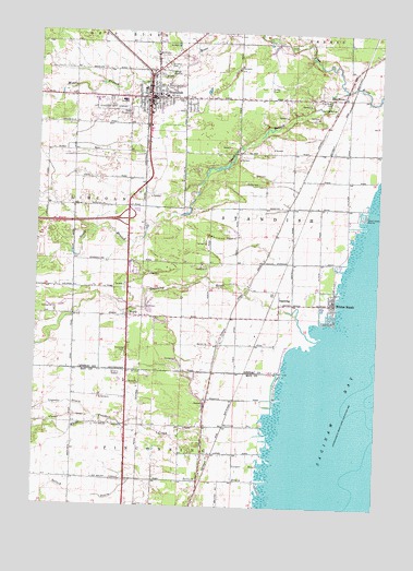
Standish, MI USGS Topographic Map
Click on map above to begin viewing in our Map Viewer.

This topographic map contains these locations and features:
Feature Name Type Latitude Longitude GNIS ID View Map
Arenac County CourthouseBuildingN43.9836°W83.9564°2515021View Map
Arenac County Emergency Medical Services StandishBuildingN43.9833°W83.9556°2662139View Map
Arenac County FairgroundsLocaleN43.9781°W83.9653°1618155View Map
Arenac County Sheriff's OfficeBuildingN43.9836°W83.9567°2737388View Map
Au Gres Sims High SchoolSchoolN43.9814°W83.9639°2515029View Map
City of StandishCivilN43.9792°W83.9631°1627118View Map
Community United Methodist ChurchChurchN43.9811°W83.9581°2515038View Map
Cooper DrainCanalN43.8856°W83.9214°623786View Map
Dudley Airport (historical)AirportN43.9867°W83.9164°1624169View Map
Faith Baptist ChurchChurchN43.9836°W83.9872°2515039View Map
Grace Episcopal ChurchChurchN43.9833°W83.9572°2515023View Map
Great Lakes MarinaHarborN43.9525°W83.8794°627276View Map
Hartzog DrainCanalN43.8964°W83.9244°627897View Map
Holy Cross Lutheran ChurchChurchN43.9822°W83.9472°2515037View Map
Indian CemeteryCemeteryN43.9278°W83.9167°2515133View Map
Legness DrainStreamN43.8978°W83.9767°630283View Map
Light of Christ Lutheran ChurchChurchN43.9667°W83.9606°2515027View Map
Living Waters Christian ChurchChurchN43.8953°W83.9667°2547384View Map
Michigan Department of Natural Resources Standish Field OfficeBuildingN43.9896°W83.9600°2626989View Map
Middle Branch Pine RiverStreamN43.9997°W83.9317°632238View Map
Pine RiverPopulated PlaceN43.9834°W83.8886°634982View Map
Pine River CemeteryCemeteryN43.9811°W83.8928°634989View Map
Pine River Golf ClubLocaleN43.9831°W83.8964°2515041View Map
Pine River Post Office (historical)Post OfficeN43.9833°W83.8886°2515121View Map
Pine River StationLocaleN43.9833°W83.8869°2515116View Map
Resurrection of the Lord Catholic ChurchChurchN43.9825°W83.9661°2515032View Map
Resurrection of the Lord CemeteryCemeteryN43.9819°W83.9472°2515132View Map
River of Life FellowshipChurchN43.9175°W83.9661°2547383View Map
SaganingPopulated PlaceN43.9289°W83.9103°636487View Map
Saganing Indian Methodist Mission CemeteryCemeteryN43.9255°W83.9114°2515134View Map
Saganing Post Office (historical)Post OfficeN43.9289°W83.9103°2515120View Map
Saganing RiverStreamN43.9195°W83.8958°636490View Map
Saganing StationLocaleN43.9306°W83.9117°2515114View Map
Saint Johns CemeteryCemeteryN43.9911°W83.9525°636726View Map
Saint Mary's of Michigan Standish Community HospitalHospitalN43.9819°W83.9691°2515034View Map
Selleck DrainStreamN43.8820°W83.9130°637568View Map
South Branch Pine RiverStreamN43.9856°W83.8880°638304View Map
StandishPopulated PlaceN43.9831°W83.9589°638715View Map
Standish Baptist ChurchChurchN43.9828°W83.9629°2371849View Map
Standish Baptist ChurchChurchN43.9825°W83.9650°2515033View Map
Standish City HallBuildingN43.9844°W83.9558°2515028View Map
Standish County Sheriff's OfficeBuildingN43.9839°W83.9564°2515022View Map
Standish Elementary SchoolSchoolN43.9831°W83.9536°2515042View Map
Standish Fire AuthorityBuildingN43.9822°W83.9712°2626806View Map
Standish Free Methodist ChurchChurchN43.9883°W83.9586°2515035View Map
Standish Industrial Airport (historical)AirportN43.9797°W83.9742°1624170View Map
Standish LibraryBuildingN43.9833°W83.9633°2515030View Map
Standish Nature PreserveParkN43.9375°W83.8925°2515079View Map
Standish Police DepartmentBuildingN43.9841°W83.9562°2737589View Map
Standish Post OfficePost OfficeN43.9817°W83.9572°2515024View Map
Standish Sold Rock Assembly ChurchChurchN43.9828°W83.9425°2515036View Map
Standish StationLocaleN43.9819°W83.9603°2515031View Map
Township of StandishCivilN43.9538°W83.9156°1627119View Map
White Feather CreekStreamN43.8945°W83.9136°1616312View Map
White Feather Post Office (historical)Post OfficeN43.8964°W83.9644°2547908View Map
White Feather Station (historical)LocaleN43.8964°W83.9633°2547444View Map
Whites BeachPopulated PlaceN43.9295°W83.8911°1616368View Map
Woodmere CemeteryCemeteryN43.9928°W83.9530°1616777View Map
WorthPopulated PlaceN43.9253°W83.9655°1616826View Map
Worth Post Office (historical)Post OfficeN43.9253°W83.9656°2515118View Map
Worth StationLocaleN43.9253°W83.9617°2515115View Map

Note: Coordinates in the location and feature list above are referenced to NAD83 datum.


Copyright (C) 2008-2025 Ryan Niemi / Sunset Dynamics ... All Rights Reserved