TopoQuest Logo
Do you find TopoQuest useful?
Help keep TopoQuest running and adding new maps/features by donating!
Bitcoin:  19c7KJd3qBynnjoSw5npx9KScwjBe4ifkT
Litecoin:  LXs6TkuXGGXo1vDsWCkWVdjQX94eUKd6ui
Home View Maps Find Maps Find Places Resources & Links


Strawberry Point, Iowa Topographic Map

USGS Map Title: Strawberry Point, IA
USGS Map MRC: 42091F5
DRG (GeoTIFF) Download: o42091f5.tif


Neighboring USGS Topographic Map Quads:


  Wadena, IA  
42091G6
 

  Volga, IA  
42091G5
 

  Elkader, IA  
42091G4
 

  Arlington, IA  
42091F6
 

  Strawberry Point, IA  
42091F5
 

  Edgewood, IA  
42091F4
 

  Lamont, IA  
42091E6
 

  Dundee, IA  
42091E5
 

  Thorpe, IA  
42091E4


Map MRC Location:

N43°
W92°
N43°
W91°
H8 H7 H6 H5 H4 H3 H2 H1
G8 G7 G6 G5 G4 G3 G2 G1
F8 F7 F6 F5 F4 F3 F2 F1
E8 E7 E6 E5 E4 E3 E2 E1
D8 D7 D6 D5 D4 D3 D2 D1
C8 C7 C6 C5 C4 C3 C2 C1
B8 B7 B6 B5 B4 B3 B2 B1
A8 A7 A6 A5 A4 A3 A2 A1
N42°
W92°
N42°
W91°

Strawberry Point, IA USGS 1:24K Topographic Map Preview:
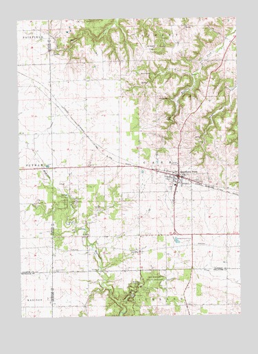
Strawberry Point, IA USGS Topographic Map
Click on map above to begin viewing in our Map Viewer.

This topographic map contains these locations and features:
Feature Name Type Latitude Longitude GNIS ID View Map
Backbone Golf and Country ClubLocaleN42.6458°W91.5585°1949067View Map
Backbone State ForestForestN42.6405°W91.5499°454299View Map
Baron SpringSpringN42.7269°W91.5485°454367View Map
Believers in Grace FellowshipChurchN42.6828°W91.5321°1949080View Map
Big SpringSpringN42.7161°W91.5399°454629View Map
Bruce CreekStreamN42.6730°W91.5965°454873View Map
Camp EwaluLocaleN42.6742°W91.5935°455118View Map
Cass Post Office (historical)Post OfficeN42.6583°W91.5974°1949049View Map
City of Strawberry PointCivilN42.6803°W91.5350°2395986View Map
Community Bible ChurchChurchN42.6778°W91.5418°1949079View Map
County Corners CemeteryCemeteryN42.6442°W91.6057°455674View Map
County Courners CemeteryCemeteryN42.6444°W91.6057°1949265View Map
Emmanuel Lutheran ChurchChurchN42.6878°W91.5349°1949078View Map
Fenchel CreekStreamN42.6297°W91.5690°456570View Map
Independent District Pleasant Prairie School (historical)SchoolN42.7203°W91.6115°464026View Map
Joy Springs County ParkParkN42.6733°W91.5988°458007View Map
Maquoketa River Wildlife AreaParkN42.6750°W91.6029°1948991View Map
Old Mission Road Historical MarkerParkN42.6842°W91.5357°1949068View Map
Reeds CemeteryCemeteryN42.7353°W91.6052°460573View Map
Richmond SpringSpringN42.6383°W91.5576°460624View Map
Saint Mary CemeteryCemeteryN42.6816°W91.5223°1949263View Map
Saint Marys Catholic ChurchChurchN42.6844°W91.5410°1949082View Map
Saint SebaldPopulated PlaceN42.7383°W91.5460°464732View Map
Saint Sebald Lutheran CemeteryCemeteryN42.7388°W91.5458°1949266View Map
Saint Sebald Post Office (historical)Post OfficeN42.7383°W91.5460°1949018View Map
Saint Sebalds Lutheran ChurchChurchN42.7386°W91.5468°1949083View Map
South SpringSpringN42.7080°W91.5376°461811View Map
Strawberry PointPopulated PlaceN42.6836°W91.5340°462032View Map
Strawberry Point (historical)LocaleN42.6844°W91.5349°1949071View Map
Strawberry Point Ambulance ServiceBuildingN42.6834°W91.5332°2599781View Map
Strawberry Point Chiropractic ClinicHospitalN42.6853°W91.5335°1949076View Map
Strawberry Point City HallBuildingN42.6836°W91.5340°1949072View Map
Strawberry Point City Police DepartmentBuildingN42.6828°W91.5347°1949074View Map
Strawberry Point Fire and RescueBuildingN42.6828°W91.5349°2577255View Map
Strawberry Point LibraryBuildingN42.6836°W91.5340°1949073View Map
Strawberry Point Lutheran HomeHospitalN42.6889°W91.5346°1949077View Map
Strawberry Point Medical CenterHospitalN42.6839°W91.5329°1949075View Map
Strawberry Point Medical Center HeliportAirportN42.6919°W91.5332°466954View Map
Strawberry Point Methodist CemeteryCemeteryN42.6816°W91.5238°1949264View Map
Strawberry Point Post OfficePost OfficeN42.6825°W91.5321°1949070View Map
Sugar Camp HollowValleyN42.7214°W91.5000°462049View Map
Township of CassCivilN42.6880°W91.5470°467540View Map
United Methodist ChurchChurchN42.6836°W91.5371°1949081View Map
Wilder Memorial MuseumBuildingN42.6842°W91.5357°1949069View Map

Note: Coordinates in the location and feature list above are referenced to NAD83 datum.


Copyright (C) 2008-2025 Ryan Niemi / Sunset Dynamics ... All Rights Reserved