TopoQuest Logo
Do you find TopoQuest useful?
Help keep TopoQuest running and adding new maps/features by donating!
Bitcoin:  19c7KJd3qBynnjoSw5npx9KScwjBe4ifkT
Litecoin:  LXs6TkuXGGXo1vDsWCkWVdjQX94eUKd6ui
Home View Maps Find Maps Find Places Resources & Links


Strykersville, New York Topographic Map

USGS Map Title: Strykersville, NY
USGS Map MRC: 42078F4
DRG (GeoTIFF) Download: o42078f4.tif


Neighboring USGS Topographic Map Quads:


  East Aurora, NY  
42078G5
 

  Cowlesville, NY  
42078G4
 

  Attica, NY  
42078G3
 

  Holland, NY  
42078F5
 

  Strykersville, NY  
42078F4
 

  Johnsonburg, NY  
42078F3
 

  Sardinia, NY  
42078E5
 

  Arcade, NY  
42078E4
 

  Bliss, NY  
42078E3


Map MRC Location:

N43°
W79°
N43°
W78°
H8 H7 H6 H5 H4 H3 H2 H1
G8 G7 G6 G5 G4 G3 G2 G1
F8 F7 F6 F5 F4 F3 F2 F1
E8 E7 E6 E5 E4 E3 E2 E1
D8 D7 D6 D5 D4 D3 D2 D1
C8 C7 C6 C5 C4 C3 C2 C1
B8 B7 B6 B5 B4 B3 B2 B1
A8 A7 A6 A5 A4 A3 A2 A1
N42°
W79°
N42°
W78°

Strykersville, NY USGS 1:24K Topographic Map Preview:
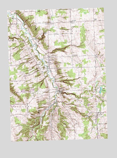
Strykersville, NY USGS Topographic Map
Click on map above to begin viewing in our Map Viewer.

This topographic map contains these locations and features:
Feature Name Type Latitude Longitude GNIS ID View Map
Angel FallsFallsN42.6712°W78.4347°942475View Map
Beaver MeadowSwampN42.6717°W78.3781°943400View Map
Beaver Meadow CreekStreamN42.6720°W78.4386°969863View Map
Beaver Meadow Family CampgroundLocaleN42.6648°W78.3858°2615183View Map
Bloecher Farm AirportAirportN42.7489°W78.4627°978327View Map
Brown BrookStreamN42.6615°W78.4406°944904View Map
Crow HillSummitN42.6681°W78.4825°947842View Map
Dutch HollowPopulated PlaceN42.7373°W78.4447°948858View Map
Erie County Reforestation AreaForestN42.6401°W78.4650°949686View Map
Fontaine FarmLocaleN42.7233°W78.4164°2707189View Map
Frink's Corners CemeteryCemeteryN42.7055°W78.3871°2515230View Map
Frinks CornerPopulated PlaceN42.7048°W78.3881°972518View Map
Glade CreekStreamN42.7028°W78.4567°951151View Map
Java CenterPopulated PlaceN42.6501°W78.3859°953943View Map
Java Center Post OfficePost OfficeN42.6505°W78.3877°2617977View Map
Java VillagePopulated PlaceN42.6726°W78.4361°953945View Map
Java Village CemeteryCemeteryN42.6700°W78.4363°953942View Map
Java Village Post OfficePost OfficeN42.6709°W78.4357°2617978View Map
Johnson FallsFallsN42.7273°W78.4542°954119View Map
North Java Volunteer Fire Department Station 2BuildingN42.6499°W78.3820°2735496View Map
Pingrey Dairy FarmLocaleN42.7056°W78.4319°2707179View Map
Plants CornerPopulated PlaceN42.7045°W78.4181°972953View Map
Plato Brook FarmsLocaleN42.6322°W78.4147°2707192View Map
Plato CreekStreamN42.6598°W78.4392°960678View Map
Saint Caecilias SchoolSchoolN42.7376°W78.4172°963402View Map
Saint Cecilia's CemeteryCemeteryN42.7383°W78.4169°2515231View Map
Saint Cecilia's Roman Catholic ChurchChurchN42.7372°W78.4175°2515232View Map
Saint Cecilias South CemeteryCemeteryN42.7323°W78.4169°963401View Map
Saint John's CemeteryCemeteryN42.7374°W78.4476°2515233View Map
Saint John's United Church of ChristChurchN42.7367°W78.4442°963654View Map
Saint Marys CemeteryCemeteryN42.6937°W78.4539°963895View Map
Saint Marys SchoolSchoolN42.6992°W78.4489°963986View Map
Saint Patrick's CemeteryCemeteryN42.6511°W78.3833°2515228View Map
Saint Patrick's ChurchChurchN42.6497°W78.3844°2515229View Map
Saint Patricks SchoolSchoolN42.6503°W78.3839°964090View Map
School Number 1 (historical)SchoolN42.6742°W78.4364°974895View Map
School Number 10 (historical)SchoolN42.6992°W78.4478°974945View Map
School Number 11 (historical)SchoolN42.6973°W78.4634°974981View Map
SheldonPopulated PlaceN42.7373°W78.4186°965009View Map
Sheldon CenterPopulated PlaceN42.7378°W78.3884°965013View Map
Sheldon CreekStreamN42.7217°W78.4728°965015View Map
Sheldon Volunteer Fire CompanyBuildingN42.7370°W78.4171°2735497View Map
StrykersvillePopulated PlaceN42.7051°W78.4484°966650View Map
Strykersville CemeteryCemeteryN42.6943°W78.4536°966651View Map
Strykersville Census Designated PlaceCensusN42.7080°W78.4484°2628188View Map
Strykersville Pioneer CemeteryCemeteryN42.7043°W78.4468°2515234View Map
Strykersville Post OfficePost OfficeN42.7031°W78.4485°2618147View Map
Strykersville Volunteer Fire CompanyBuildingN42.6936°W78.4452°2700909View Map
Town of JavaCivilN42.6507°W78.3859°979104View Map
Town of SheldonCivilN42.7376°W78.3859°979488View Map
Vista View FarmsLocaleN42.6847°W78.4806°2703288View Map
Wales HollowPopulated PlaceN42.7426°W78.4884°968672View Map
Wales Hollow Lutheran ChurchChurchN42.7431°W78.4881°2714321View Map

Note: Coordinates in the location and feature list above are referenced to NAD83 datum.


Copyright (C) 2008-2025 Ryan Niemi / Sunset Dynamics ... All Rights Reserved