TopoQuest Logo
Do you find TopoQuest useful?
Help keep TopoQuest running and adding new maps/features by donating!
Bitcoin:  19c7KJd3qBynnjoSw5npx9KScwjBe4ifkT
Litecoin:  LXs6TkuXGGXo1vDsWCkWVdjQX94eUKd6ui
Home View Maps Find Maps Find Places Resources & Links


Thompson, Ohio Topographic Map

USGS Map Title: Thompson, OH
USGS Map MRC: 41081F1
DRG (GeoTIFF) Download: o41081f1.tif


Neighboring USGS Topographic Map Quads:


  Perry, OH  
41081G2
 

  Madison, OH  
41081G1
 

  Geneva, OH  
41080G8
 

  Painesville, OH  
41081F2
 

  Thompson, OH  
41081F1
 

  East Trumbull, OH  
41080F8
 

  Chardon, OH  
41081E2
 

  East Claridon, OH  
41081E1
 

  Windsor, OH  
41080E8


Map MRC Location:

N42°
W82°
N42°
W81°
H8 H7 H6 H5 H4 H3 H2 H1
G8 G7 G6 G5 G4 G3 G2 G1
F8 F7 F6 F5 F4 F3 F2 F1
E8 E7 E6 E5 E4 E3 E2 E1
D8 D7 D6 D5 D4 D3 D2 D1
C8 C7 C6 C5 C4 C3 C2 C1
B8 B7 B6 B5 B4 B3 B2 B1
A8 A7 A6 A5 A4 A3 A2 A1
N41°
W82°
N41°
W81°

Thompson, OH USGS 1:24K Topographic Map Preview:
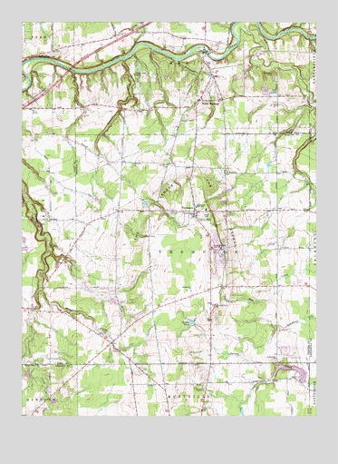
Thompson, OH USGS Topographic Map
Click on map above to begin viewing in our Map Viewer.

This topographic map contains these locations and features:
Feature Name Type Latitude Longitude GNIS ID View Map
Bates CreekStreamN41.6648°W81.1176°1066559View Map
Birdland AirportAirportN41.6571°W81.1063°1083044View Map
Bold "N" Ranch And FarmLocaleN41.7253°W81.0214°2516128View Map
BostwickPopulated PlaceN41.6509°W81.0832°1062403View Map
Bostwick Post Office (historical)Post OfficeN41.6514°W81.0832°1988328View Map
Bostwicks Corners Cemetery (historical)CemeteryN41.6509°W81.0832°1963328View Map
BreakmanPopulated PlaceN41.6584°W81.1129°1062406View Map
Breakman Post Office (historical)Post OfficeN41.6584°W81.1123°2025604View Map
Bush FieldAirportN41.6801°W81.0371°1083043View Map
Calm (historical)Populated PlaceN41.6903°W81.0026°1067574View Map
Calm Post Office (historical)Post OfficeN41.6903°W81.0026°1988332View Map
Camp StigwandishLocaleN41.7334°W81.0195°1052827View Map
Clague Farm CemeteryCemeteryN41.7224°W81.1203°1963310View Map
Curtis AirportAirportN41.6384°W81.1008°1082560View Map
Debevc FarmLocaleN41.7386°W81.0008°2516129View Map
Evergreen CemeteryCemeteryN41.7048°W81.0648°1963335View Map
Gore ChurchChurchN41.7262°W81.0487°1963312View Map
Gore Church CemeteryCemeteryN41.7264°W81.0493°1963313View Map
Grace Lutheran ChurchChurchN41.6506°W81.0904°1041003View Map
Griswold CreekStreamN41.7376°W81.0601°1041189View Map
Hell HollowBasinN41.6870°W81.1195°1067077View Map
Hell Hollow Metropolitan ParkParkN41.6870°W81.1193°1052833View Map
Hidden Valley Metropolitan ParkParkN41.7417°W81.0548°1052831View Map
Hogback Ridge Metropolitan ParkParkN41.7467°W81.0262°1052828View Map
Kittredge PondReservoirN41.6297°W81.1113°1078264View Map
Kittredge Pond DamDamN41.6301°W81.1132°1078263View Map
Lake Erie Girl Scout LakeReservoirN41.6779°W81.1243°1078230View Map
Lake Erie Girl Scout Lake DamDamN41.6784°W81.1232°1078229View Map
Lausin FarmsLocaleN41.6744°W81.0353°2516130View Map
Ledgemont Elementary SchoolSchoolN41.6912°W81.0509°1057790View Map
Ledgemont High SchoolSchoolN41.6906°W81.0468°1057739View Map
Little Thunder Golf CourseLocaleN41.7367°W81.0439°2123238View Map
Madison Fire District Station 3BuildingN41.7249°W81.0492°2549087View Map
Madison PalisadesCliffN41.7431°W81.0498°1083199View Map
Maple Grove CemeteryCemeteryN41.6895°W81.0604°1042952View Map
Mill CreekStreamN41.7451°W81.0337°1043319View Map
Montmere LakeReservoirN41.6403°W81.0110°1078262View Map
Montmere Lake DamDamN41.6367°W81.0048°1078261View Map
Pheasant Run AirportAirportN41.7116°W81.1201°1082787View Map
Phelps CreekStreamN41.6651°W81.1179°1044413View Map
River Road ParkParkN41.7403°W81.0887°1052832View Map
Riverview Metropolitan ParkParkN41.7403°W81.0415°1052830View Map
Rustic Pine Mobile Home ParkPopulated PlaceN41.6683°W81.0094°2508941View Map
Saint Patrick CemeteryCemeteryN41.6426°W81.0171°1963354View Map
Saint Patricks ChurchChurchN41.6434°W81.0170°1045735View Map
Saint Patricks ChurchChurchN41.6648°W81.0529°1066295View Map
Sky Haven AirportAirportN41.7211°W81.1063°2442529View Map
South MadisonPopulated PlaceN41.7253°W81.0501°1049192View Map
South ThompsonPopulated PlaceN41.6478°W81.0448°1057740View Map
South Thompson Post Office (historical)Post OfficeN41.6473°W81.0443°1988361View Map
Spring PondLakeN41.6547°W81.0529°1046570View Map
Stony Glen CampLocaleN41.7331°W81.0776°1046728View Map
Talcott CreekStreamN41.7381°W81.0815°1046937View Map
The LedgesBenchN41.6912°W81.0682°1067006View Map
The Reserve At Thunder Ridge Golf CourseLocaleN41.7306°W81.0397°2123245View Map
ThompsonPopulated PlaceN41.6901°W81.0515°1047029View Map
Thompson Drag Raceway AirportAirportN41.6470°W81.0069°1083042View Map
Thompson Fire and RescueBuildingN41.6884°W81.0516°2550263View Map
Thompson Ledge Township ParkParkN41.6870°W81.0443°1047038View Map
Thompson Methodist ChurchChurchN41.6892°W81.0519°2088030View Map
Thompson Police DepartmentBuildingN41.6884°W81.0513°2733013View Map
Thompson Post OfficePost OfficeN41.6903°W81.0512°1988366View Map
Thunder Hill Country ClubLocaleN41.7345°W81.0409°1052829View Map
Township of ThompsonCivilN41.6782°W81.0525°1086161View Map
Wheeler (historical)Populated PlaceN41.7334°W81.0443°1067437View Map
Wheeler Post Office (historical)Post OfficeN41.7334°W81.0443°2025628View Map
Whispering Pines Airport (historical)AirportN41.6653°W81.0373°1083041View Map

Note: Coordinates in the location and feature list above are referenced to NAD83 datum.


Copyright (C) 2008-2024 Ryan Niemi / Sunset Dynamics ... All Rights Reserved